Download
1 / 43
430 likes | 566 Views
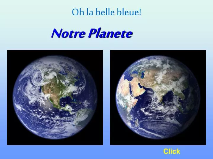
Oh la belle bleue!. Notre Planete. Click. QUEL SPECTACLE d’un satellite en orbite!. Photos prises lors de journées sans nuages. LA NUIT TOMBE SUR LA TERRE. Regarde à Paris et à Barcelone, les lumières sont déjà allumées, tandis qu’à Londres, Lisbonne et Madrid le soleil est encore là.

E N D
Oh la belle bleue! Notre Planete Click
QUEL SPECTACLEd’un satellite en orbite! Photos prises lors de journées sans nuages.
LA NUIT TOMBE SUR LA TERRE. Regarde à Paris et à Barcelone, les lumières sont déjà allumées, tandis qu’à Londres, Lisbonne et Madrid le soleil est encore là. Au Sud on voit les îles dans le milieu de l’océan. La vue des îles Britanniques, de l’Islande et du Canada est parfaite.
Islande Angleterre Océan Atlantique France Espagne Italie AFRIQUE
La photo suivante, prise telle quelle d’un satellite, est la nuit qui tombe au Brésil. La deuxième est la même avec une modification des nuances pour mieux voir les lumières. Les deux photos suivantes, sont sur l’Amérique du Nord.
Océan Atlantique Belo Horizonte Salvador Rio de Janeiro Grand São Paulo
Fortaleza Brasília Recife Goiânia Salvador Uberlândia Belo Horizonte Rio de Janeiro Grande São Paulo Florianópolis
Saguenay Sept-Iles Thunder Bay Toronto St.John Ottawa Il fait encore jour en Californie Québec Montréal Ces lumières sont Boston, New York, Philadelphie et Washington. Detroit Dallas Puerto Rico Houston Miami Mexico City Havana
Sud de la Peninsule Ibérique. Une tempête de sable quitte le Nord de l’Afrique. Iles Canaries
Iles Canaries Maroc
Mer Méditerranée Malaga Espagne Gibraltar Maroc Tanger
Les Alpes suisses et le lac Léman
Lac de Neuchâtel Lac Léman
Russie Mer d’Azov Roumanie Mer Noire Bulgarie Istanbul Turquie
Le Nil Arabie Saoudite Egypte Mer Rouge
Même plongée dans le noir elle est magnifique…
Magnifique, pas vrai?? Alors, pour que tes enfants et petits-enfants puissent bénéficier de ce spectacle longtemps… S’il te plaît, transmets ce message pour que tout un chacun puisse prendre conscience de ce qu’il a sous les pieds. Fin
Great Satellite images .... with excellent descriptions.
Fantastic geography to view from hundreds of miles in space.
Palm Island, Dubai, United Arab Emirates This IKONOS satellite image was collected on July 16, 2004. The Image shows this man-made island that lies off the coast of Dubai in the Persian Gulf. The island is being built from 80 million cubic meters of land dredged from the approach channel to the Emirate's Jebel Ali Port. When complete, this resort will have 1,200 single-family and 600 multi-family residences, an aquatic Theme park, shopping centers, cinemas and more.
The Great Pyramid, Giza, Egypt This is a 61-centimeter pan-sharpened image of the Great Pyramid in Giza, Egypt, collected by QuickBird on February 2, 2002. The Great Pyramid is estimated to have been built circa 2650 B.C., and was erected as a tomb for the Egyptian pharaoh Khufu of The Fourth Dynasty. Upon the completion of its construction, the Great Pyramid stood 145.75 meters (481 feet) high, and over the Millennia has lost approximately 10 meters (30 feet) off the top. It stood as the tallest structure on Earth for more than 43 centuries
Niagara Falls This shows the Niagara River that connects Lake Erie to Lake Ontario, snaking around Goat Island, in the lower left of the full Image. Most of the river's water plummets over the Canadian/Horseshoe Falls, but some diverted water spills over American Falls and Bridal Veil Falls downstream. Every second, more Than two million liters of water plunges over the Horsehoe Falls Segment of Niagara Falls creating one of the world's largest Waterfalls as wellas eating away as much as two meters of rock per Year. The image was acquired August 2, 2004
Tsunami strikes the coast of Sri Lanka This is a natural color, 60-centimeter (2-foot) high-resolution QuickBird satellite image featuring the southwestern coast of Sri Lanka. Imagery was collected on December 26, 2004 at 10:20 a.m. Local time, slightly less than four hours after the 6:28 a.m. (local Sri Lanka time) earthquake and shortly after the moment of tsunami impact.
Ground Zero, New York City This one-meter resolution satellite image of Manhattan, New York was collected at 11:43 a.m. EDT on Sept. 12, 2001 by Space Imaging's IKONOS satellite. The image shows an area of white and gray-colored Dust and smoke at the location where the 1,350-foot towers of the World Trade Center once stood. Since all airplanes were grounded Over the U.S. after the attack, IKONOS was the only commercial High-resolution camera that could take an overhead image at the time.
Grand Canyon Northern Arizona and the Grand Canyon are captured in this pair of Multi-angle Imaging Spectroradiometer (MISR) images from December 31, 2000. The above image is a true color view from the nadir Vertical camera. In addition to the Grand Canyon itself, which is visible in the western (lower) half of the images, other landmarks include Lake Powell, on the left, and Humphreys Peak and Sunset Crater National Monument on the right. Meteor Crater appears as a small dark depression with a brighter rim, and is just visible along the upper right-hand edge.
Malosmadulu Atolls, Maldives North and South Malosmadulu Atolls are in the Maldives, an island Republic in the northern Indian Ocean, southwest of India. The Maldives are made up of a chain of 1,192 small coral islands, which are grouped into clusters of atolls. It has a total area of 298 Square kilometers and a population of about 330,000. The capital and largest city is Male, with a population of about 80,000. Arguably the lowest-lying country in the world, the average elevation is just 1 meter above sea level. The natural-color ASTER image of the Malosmadulu Atolls was acquired on December 22, 2002, and is centered near 5.3 degrees North latitude, 73.9 degrees West longitude.
Ayers Rock (Uluru), Australia This IKON OS satellite image of Ayers Rock was collected Jan. 17, 2004. Ayers Rock is located in Kata Tjuta National Park, 280 miles 450km) southwest of Alice Springs, Australia. It is the world's largest monolith, an Aboriginal sacred site and Australia's most famous natural landmark.
Noah's Ark Site? Is it or isn't it? Satellite images of Mt. Ararat, Turkey have pointed to a possible sighting of Noah's Ark. Decide for yourself! Compare this image taken by Digital Globe on September 10, 2003 with Shamrock -- The Trinity Corporation's image (enlarge). Also, note their image is flipped.
The Nile River This image of the Nile River was captured by the MISR's nadir camera on January 30, 2001. Against the barren desert of northeastern Africa, the fertile valley of the Nile River runs northward through Egypt. The city of Cairo can be seen as a gray smudge right where the river widens into its broad fan-shaped delta. Where the Nile empties into the Mediterranean Sea (top) the waters are swirling with color, likely a mixture of sediment, organic matter, and possibly marine plant life. Farther west, the bright blue color of the water is likely less-organically rich sediment, perhaps sand.
Earth's City Lights This image of Earth's city lights, captured on October 19, 2000, was created with data from the Defense Meteorological Satellite Program (DMSP) Operational Linescan System (OLS). The brightest areas of the Earth are the most urbanized, but not necessarily the most populated. Cities tend to grow along coastlines and transportation networks. The United States interstate highway system appears as a lattice connecting the brighter dots of city centers. In Russia, the Trans-Siberian railroad is a thin line stretching from Moscow through the center of Asia to Vladivostok. The Nile River, from the Aswan Dam to the Mediterranean Sea, is another bright thread through an otherwise dark region.
Mount St. Helens, Washington On a Space Station expedition, astronauts observed and captured this detailed image of the volcano's summit caldera. In the center of the crater sits a lava dome that is 876 feet above the crater floor and is about 3,500 feet in diameter. The dome began to form after the May 18, 1980 eruption of Mount Saint Helens. After the eruption, there was not any dome building eruptions for more than a decade. Afternoon lighting accents the flow features in the volcanic and debris flows and the steep valleys eroded into the loosely consolidated material near the summit. This picture was taken on October 25, 2002.
The End Thank You Hy-Văn Click to End