Download
1 / 14
140 likes | 145 Views
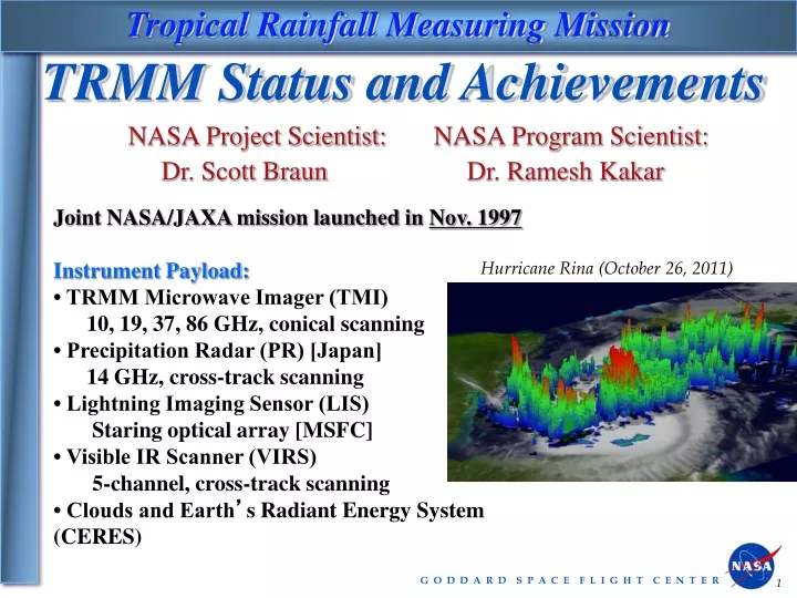
Tropical Rainfall Measuring Mission. TRMM Status and Achievements. NASA Project Scientist: Dr. Scott Braun. NASA Program Scientist: Dr. Ramesh Kakar. Joint NASA/JAXA mission launched in Nov. 1997 Instrument Payload: • TRMM Microwave Imager (TMI)

E N D
Tropical Rainfall Measuring Mission TRMM Status and Achievements NASA Project Scientist: Dr. Scott Braun NASA Program Scientist: Dr. Ramesh Kakar Joint NASA/JAXA mission launched in Nov. 1997 Instrument Payload: • TRMM Microwave Imager (TMI) 10, 19, 37, 86 GHz, conical scanning • Precipitation Radar (PR) [Japan] 14 GHz, cross-track scanning • Lightning Imaging Sensor (LIS) Staring optical array [MSFC] • Visible IR Scanner (VIRS) 5-channel, cross-track scanning • Clouds and Earth’s Radiant Energy System (CERES) Hurricane Rina (October 26, 2011)
Focus Areas TRMM Science Accomplishments Key focus areas: • Science Accomplishments • Applications • Status
TRMM Rainfall: Climatology From Adler et al. (2009) • Benchmark ~16 year climatology • Unique monitoring of interannual rainfall variations related to ENSO • TRMM estimates have become the standard for improving long-term climatologies and for comparison to global climate models From Dai (2006)
TRMM Rainfall: Diurnal Cycle • Low inclination (35°), precessing orbit allows sampling of all local hours over several weeks • Quantification of diurnal cycle of precipitation tropics wide • Has also allowed focus on regional and local scales • Comparison with global climate models From Nesbitt and Zipser (2003)
Convective Extremes—Overshooting Storms Deep overshooting convective towers impact the water vapor mass exchange between the troposphere and stratosphere • University of Utah TRMM Precipitation Feature database used to identify tropical deep convection with overshooting tops • Only 1.3% of convective systems reach 14 km height • These overshooting storms are most prevalent over land, especially over central Africa, Indonesia, and South America. Number density (%) of PR tops exceeding 14 km Liu and Zipser (2005)
Impact of humans on Rainfall Impact of Cities on Rainfall Effects of Pollution on Rainfall Over Ocean 1 3 2 Houston downwind rainfall maximum (Shepherd) Lack of PR-detected rain in polluted clouds (Rosenfeld) Pollution Impact on Rainfall Over Land Increase in Summer Rain over SE U.S. during week (red curve)--Increase offshore on weekend (blue curve)--(Bell)
TRMM Advances For Hurricane Science • Rainfall climatology for hurricanes • Detailed rainfall structure and lightning in eye wall and rainbands • The role of “hot towers” in storm intensification • Rainfall accumulations and monitoring of flood/landslide potential • Improved simulations of hurricanes
Tropical Cyclones: Applications TRMM data used by NOAA, DoD, and int’l agencies for tropical cyclone detection, location and intensity estimation ~500 TRMM tropical cyclone “fixes” per year TRMM orbit always in tropics, sampling best in 10-35º latitude storm band High horizontal resolution Precessing orbit provides off-time observations relative to sun-synchronous satellites Hurricane Katrina TRMM image from NRL Tropical Cyclone web site Hurricane Katrina-2005 TRMM radar (PR) cross-sections of hurricanes available in real-time for operational analysis from TRMM web site from TRMM web site
TRMM Multi-Satellite Precipitation Analysis 3-hr window with passive microwave (gaps filled with Geo-IR) calibrated by TRMM (0.25° grid) Research product uses TRMM radar information and monthly gauges--real-time product avail. ~6 hrs. after obs. time 9 years+ (‘98-’07)of 3-hr analysis available--produced at TRMM data system. Available from Goddard DISC (most downloaded TRMM product)
Applications • Monitoring of Disasters • Tropical cyclones • Floods/Landslides • Disease • Drought • Fires/fire risk • Hydrological applications • Water resources • Streamflow/floods • Soil moisture • Agriculture
TRMM Estimates of Storm-Total Rainfall TRMM Detects Heavy Rainfall in Dominican Republic from Tropical Storm Noel • TRMM Multi-satellite precipitation analysis measures >400 mm of rain over D. R. and Haiti from Noel • 81 deaths, several hundred thousand displaced “Your images have bee incredible--they are stunning and extremely useful. It was even presented to the minister of environment an head of disasters in the DR. Deeply appreciated. Please know we are crediting you everywhere.” – Daniel Irwin, MSFC, SERVIR Project Manager Images by Hal Pierce, NASA/GSFC
Global Flood Monitoring System (GFMS) Global Real-time Flood Calculations Using Satellite Rainfall and Hydrological Model http://flood.umd.edu/ TRMM/GPM rainfall into land surface and routing models for water depth and stream flow calculations compared to flood thresholds TRMM calibrating rainfall from other satellites as forerunner to GPM Indus River basin Aug. 20 2013 Global Flood Detection Experimental Inundation Mapping at 1 km Resolution Time Histories at a Point Adler/Wu University of Maryland
TRMM Remaining Fuel Mass flow Method PVT Method
TRMM Notional Timeline April 2013 Predictions - Revised Predicted (high solar case) Predicted (nominal case) Predicted (low solar case) aCTUAL Passivation End of Fuel = 02/2014 402.5km 350km 335km End of Fuel = 03/2014 End of Ops End of Ops End of Ops Prime Mission (350km) Extended Mission (402.5 km) End of Fuel = 08/2014 Note: Not drawn to scale Launch 0 km 02/14 01/18 04/19 04/2013 11/1997 01/1998 08/2001 03/14 02/18 05/19 08/14 07/18 10/19