Download
1 / 49
490 likes | 662 Views
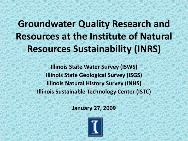
Groundwater Quality Research and Resources at the Institute of Natural Resources Sustainability (INRS). Illinois State Water Survey (ISWS) Illinois State Geological Survey (ISGS) Illinois Natural History Survey (INHS) Illinois Sustainable Technology Center (ISTC) January 27, 2009.

E N D
Groundwater Quality Research and Resources at the Institute of Natural Resources Sustainability (INRS) Illinois State Water Survey (ISWS) Illinois State Geological Survey (ISGS) Illinois Natural History Survey (INHS) Illinois Sustainable Technology Center (ISTC) January 27, 2009
Groundwater Quality Research: INRS Equipment Resources • Drilling rigs and trained personnel (ISGS) • Field equipment • Pumps • Multi-sondes (T, pH, ORP, SpC, DO, etc.) • Miscellaneous sampling equipment • Water level measurement devices
Groundwater Quality Research: INRS Analytical Laboratories • ISWS Public Service Laboratory (PSL) • Anions (ion chromatography); Metals (ICP-AES and AA); Alkalinity (titration); TKN, NH4-N, NO2-N, P (colorimetry); Organic Carbon (combustion); TDS • Free analysis for domestic well owners • ISGS Isotopic Geochemistry lab • Stable isotopes (δD, δ18O, δ13C; sample prep for δ34S) • Radioisotopes (3H-water, 14C-DIC, CH4) • Gases: N2, O2+Ar, CO2, CH4, alkanes (C2 to C6)
Groundwater Quality Research: INRS Analytical Laboratories (cont.) • ISTC analytical laboratories • Metals, including speciation and Hg (ICP-MS, AA) • Organic compounds, such as PAHs, VOCs, pesticides, etc. (HPLC and GCMS systems) • other
Groundwater Quality Research: INRS Data Resources • Databases (ISWS and ISGS) • Groundwater quality (domestic and public supply) • Well locations and logs • Water levels, aquifer properties, etc.
Groundwater Quality Researchersat INRS ISWS ISGS Sam Panno Keith Hackley Ivan Krapac William Roy Randy Locke Jim Miner Bill Dey Ed Mehnert • Walt Kelly • Tom Holm • George Roadcap • Steve Wilson • Al Wehrmann
Research Collaborators with INRS:Groundwater Quality UI Others ISU NIU SIU-Carbondale SIU-Edwardsville UI-Chicago USGS IEPA IDOA IDPH County Health Depts. Municipalities • Dept. Geology • Dept. Civil & Environmental Engineering • Dept. Materials Science • Vet/Med • ACES • NRES
INRS Groundwater Quality Research: Overview • Geochemical characterization of aquifers • Contamination • Nutrients (N) and other agricultural issues • Urbanization/land use changes • Natural drinking water contaminants • Arsenic • Radium and barium • Vulnerable Environments • Karst systems • Nature Preserves
Kane County Shallow Aquifers: Chloride Gray areas: aquifer material within 50 ft of land surface
Chicago Region: annual average snowfall: 38 inches >55,000 lane miles annual average road salt application: > 270,000 tons
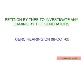
Aerial view of Lake Calumet Lake Michigan N Loop 12 miles Calumet River IL/IN Lake Calumet Wolf Lake Grand Calumet R 94 Cal Sag Channel
Lake Calumet Shallow Monitoring Wells: Cl- [1991] Wells < 20 ft 94
Public Supply Wells: Chicago Region 55% have positive trends; >60% in DuPage, Will, Kane 37% > 1 mg/L/yr; 12% > 4 mg/L/yr
Pharmaceutical and Personal Care Products (PPCPs) in the Environment Tetracycline in Soil Amendments and Soils: ISU Farm *ng/mL ^ng/g
Program Objectives: Monitoring Confined Animal Feeding Operations (CAFOS) • Monitor Long-Term Groundwater Quality Near Swine Confinement Facilities • Determine the Occurrence and Concentration of: • Nutrients • Viruses • Antibiotics • Antibiotic Resistance Genes • Evaluate the fate and transport of antibiotics and antibiotic resistance genes in soil and groundwater
Chloride Concentrations and tet Gene Frequency Chloride (mg/L) Gene Frequency (%) (2000-2003 N = 95)
Determining Soil Cleanup Objectives (SCOs) for IDOA • Derive SCOs for fertilizer NH4-N spills • Protect groundwater quality in Illinois • SCO ≈ amount sorbed plus extent of dilution times a groundwater quality objective • Movement of NH4+ as well as nitrification • 10 mg/L as N yields a default SCO of 38 mg/kg for NH4+ • Experiments showed SCOs correlated with cation exchange capacity (CEC)
Proposed Default Soil Cleanup Objectives for Ammonium: Since Promulgated by IDOA
Arsenic Solubility Affected by OM Availability Symbol size: Relative As conc.
Arsenic Removal Pilot Plant at Danvers, IL Water Treatment Plant
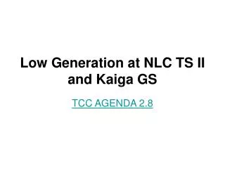
Radium (Ra) in Water from the Deep Bedrock Aquifer System Area Where 226Ra + 228Ra > 5 pCi/L has been Detected in Deep Bedrock System The USEPA drinking water standard for combined Ra is 5 pCi/L Map Modified from Kay (1999)
Nature Preserves Program • Cooperative effort of the Surveys with IDNR since 1998 • PIs: Randy Locke and Jim Miner
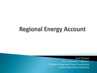
= water quality sampling location (77) = chloride conc. (mg/L), Nov 2007 Bluff Spring Fen, Chloride (Nov. 2007) 6(150) Gifford Lake P82-S(160) Clean pond(70) South Outfall(220)higher chloride Portal = generalized surface water movement = infiltration trench