Download
1 / 1
10 likes | 128 Views
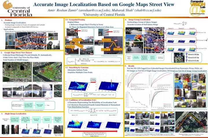
Accurate Image Localization Based on Google Maps Street View Amir Roshan Zamir † (aroshan@cs.ucf.edu), Mubarak Shah † (shah@cs.ucf.edu) † University of Central Florida. 4. Image Group Localization Geolocating a Group of Query Images Accurate Location of Each Query Image.

E N D
Accurate Image Localization Based on Google Maps Street ViewAmir RoshanZamir† (aroshan@cs.ucf.edu), Mubarak Shah† (shah@cs.ucf.edu)†University of Central Florida • 4. Image Group Localization • Geolocating a Group of Query Images • Accurate Location of Each Query Image • 3.1. Geospatial Pruning • Helpful When: • I: Reference Images Have Overlap in Scene • II: There Are Repeated Structures Such as in Urban Area • 1. Problem • Accurate Image Localization: • Finding Image Location in Terms of Longitude and Latitude • Accuracy Comparable to Hand-Held GPS Devices • Applications: • Vision-Based Navigation, Photo Organization, Crime-Scene Localization, etc. Sample Query Interest Point Sample Query Interest Point CoLgroup=0.14k 2nd NN 1st NN Descriptor Ratio: 0.95 GPS Distance: 9m Descriptor Ratio: 0.44 GPS Distance: 919m CoLgroup=2.1k 1st NN 4th NN Descriptor Ratio: 0.87 GPS Distance: 13m Descriptor Ratio: 0.56 GPS Distance: 414m 2nd NN 3rd NN CoLgroup=0.23k Descriptor Ratio: 0.94 GPS Distance: ~0m Descriptor Ratio: 0.91 GPS Distance: ~0m • 2. Google Maps Street View Dataset • Collected From Pittsburgh, PA and Orlando, FL Automatically. • 4 Side Views And 1 Top View Per Place Mark. • Total Number of 100,000 Images. 3rd NN 4th NN Error1=10.2m Error2=15.7m Error3=11.4m • I: Reference Images Have Overlap in Scene • II: Repeated Structure in Urban Area • 5. Results • Test Set: 521 GPS-Tagged User-Uploaded Images Downloaded From Panoramio, Picasa, Flickr, etc. • 311 Images as Test Set of Single Image Localization, 210 Images as Test Set of Image Group Localization. • 3.2 Smoothing by Gaussian • Attenuates Solitary Peaks • Amplifies Multiple Close Peaks =40.438880 =-80.001690 Gaussian Smoothing =40.441809 =-79.998938 =40.441191 =-80.006622 =40.440116 =-80.004033 =40.442565 =-80.000493 Dataset (Green) and Test Set (Red), Orlando, FL Dataset (Green) and Test Set (Red), Pittsburgh, PA =40.442799 =-79.998840 =40.440645 =-80.002112 =40.441421 =-80.002497 Single Image Localization Results Image Group Localization Results =40.441559 =-79.996395 =40.441745 =-79.998760 =40.443652 =-80.002507 =40.439211 =-80.004400 Top View • 3.3. Confidence of Localization (CoL) • A Parameter Representing The Reliability of Localization Task • CoL=Kurtosis (Normalized Fourth Central Moment) of Normalized Vote Distribution Function Side Views =40.441978 =-79.999055 =40.443281 =-80.000584 =40.441127 =-80.002821 =40.440715 =-80.002836 Illustration of CoLValue vs. Accuracy Breakdown of Group Image Localization Results Sample User-Uploaded Images in Test Set Along With Their Longitude () And Latitude () Block Diagram of Processing The Dataset Vote Distribution Vote Distribution Map Retrieved Image Retrieved Image Map Query Query 3. Single Image Localization Kurt=1.18 Kurt=233.42 Kurt=29865.7 Error=10.87m Error=44.77m Error=12.95m Error=29.82m Error=15.98m Error=39.61m More-Peaked VoteDistribution Results in Higher Reliability in Localization & Higher Kurtosis 6 Sample Localization Results. From Left to Right, First Column: Query, Second Column: Vote Distribution, Third Column: Retrieved Image, Forth Column: Ground Truth in Green and Found Location in Blue on The Map Along With Error. Extension To Videos: Using Temporal Continuity of Videos Red: Found Trajectory, Green: Ground Truth Retrieved Image Error =17.8m Query Image Block Diagram of Localizing a Single Query