Download
1 / 15
150 likes | 284 Views
The Open Location Services (OLS) Tracking Service Standard. Dr. Johnny Tolliver Oak Ridge National Laboratory Goeff Hendrey Telcontar Carl Stephen Smyth Mobile GIS. Open Location Services. AKA OpenLS (or just OLS) A component of the Open Geospatial Consortium (OGC)

E N D
The Open Location Services (OLS) Tracking Service Standard Dr. Johnny Tolliver Oak Ridge National Laboratory Goeff Hendrey Telcontar Carl Stephen Smyth Mobile GIS
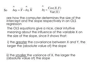
Open Location Services • AKA OpenLS (or just OLS) • A component of the Open Geospatial Consortium (OGC) • Interested in creation, promotion, and use of international standards for location services of all kinds • The location service topic of this talk is the OLS Tracking Service
What is “Tracking”? • Tracking can mean different things to different people • For the purposes here, tracking means all the components necessary to produce near-real-time “moving dots on a map” corresponding to tracked vehicles, people, assets, etc. • The tracking service is the middle-tier service component that facilitates tracking
Tracking Components Tracking Service Request/response for location data Location data Mobile Tracking Client Tracking Display Client
Short History and Motivation • ORNL has a program called SensorNet • SensorNet has a major testbed deployment at Ft. Bragg, NC • Ft. Bragg needed to track emergency response vehicles and personnel • ORNL offered to do a pilot tracking test using Nextel cell phones with GPS
Cell Phone Tracking • Most cell phones “know where you are” • Only Nextel provides an accessible API that permits user plane retrieval of location information • We used the Nextel/Motorola Location API to obtain GPS coordinates of the phone and uploaded to a server • No rocket science here, many other have done the same thing • Then displayed moving dots on a Keyhole (now Google Earth) map
Did Not Want a Proprietary System • ORNL tracking server and display client were completely proprietary • We desired a standard way of uploading and downloading location information • Standards reduce costs • Promote competitive commercial implementations • No long-term software maintenance issues for the National Lab
Needed a Standard • No such existing standard for tracking was identified • NMEA exists for GPS location information • Most (all?) GPS receivers can output NMEA-formatted data • Several software solutions can use NMEA data for mapping applications • But NMEA doesn’t really address the same issues • Thus was born the OLS Tracking Service • Created and implemented during the OGC OWS-3 testbed during Summer of 2005
What is the OLS Tracking Service? • An XML web service interface specification for tracking data • Any standard-compliant mobile tracking client can upload tracking data to the server • Any standard-compliant tracking display client can retrieve location data from the server for display • Different and competing commercial service implementations and client implementations will interoperate • Includes location privacy, historical queries, geographically bounded queries, etc. • And, of course, “current position” queries • Also supports service chaining for location push rather than pull
Example Interactions • Update the current location of a mobile phone – i.e., upload location • Retrieve the current location of a mobile phone • Retrieve the last 10 locations within 500m of (X,Y) for mobile phone 555-555-1234 • Retrieve a list of all tracked mobile phones within 500m of (X,Y) at present time • Forward position updates for phone 555-555-1234 to a specified URL
ORNL Draft Implementation • Created as part of OWS-3 • Implemented much, but not all, of the proposed standard • Used during the OWS-3 Demo in October • Display clients appear in OWS-3 demo movie
Google Earth Demo • Live demo, if network available and phones are online • Static photo if not
Status • Initial OLS Tracking Service is released as an OGC Discussion Paper for public comments • Working its way toward OGC adoption as a standard • Will be enhanced/matured in OWS-4 • Improvements to draft ORNL implementation • Fine tuned, hardened, more testing • Perhaps open-sourced • Service interface to be evolved if needed