Download
1 / 18
180 likes | 362 Views
Geography Hydrosphere. Rivers on Ordnance Survey Maps [Date] Today I will: - Be able to describe the physical features of a river and its valley on an OS map. Geography Hydrosphere.

E N D
Geography Hydrosphere Rivers on Ordnance Survey Maps [Date]Today I will:- Be able to describe the physical features of a river and its valley on an OS map
Geography Hydrosphere The typical style of question is: Describe the physical characteristics of the river X and its valley from A to B on an OS Map.
Geography Hydrosphere The typical style of question is: Describe the physical characteristics of the river X and its valley from A to B on an OS Map. Physical characteristics are natural. They do not include human features such as bridges and canals.
Geography Hydrosphere The typical style of question is: Describe the physical characteristics of the river X and its valley from A to B on an OS Map. You must write about the river AND its valley to gain full marks
Geography Hydrosphere The typical style of question is: Describe the physical characteristics of the river X and its valley from A to B on an OS Map. A and B are grid references. You must quote features from within this area. Anything outwith will gain you no marks.
Geography Hydrosphere What kind of things could you include in your answer? What physical features will you be able to see on a map? You have 60 seconds in pairs… 1 2 3 4 5 6 7 8 9 10 11 12 59 13 15 16 17 18 19 20 21 22 23 24 25 26 27 End 28 29 30 32 33 34 35 36 37 38 39 40 41 42 43 44 14 45 47 48 49 50 51 52 53 54 55 56 57 58 31 46 60
Geography Hydrosphere • How to answer this question.Use the rhyme: Does Cotton Wool Scare Poor Sheep? • Direction • Course • Width • Straight • Physical Features • Steepness of Valley
Geography Hydrosphere Direction Your first sentence should state which direction the river flowing i.e. South, North East etc. Hints: Water always flows downhill so look at the contours. Tributaries also point in the direction of downhill.
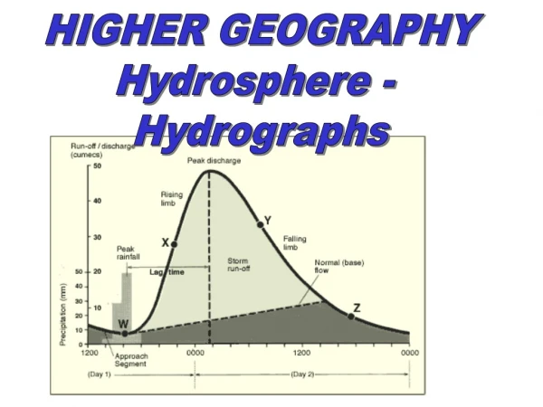
Geography Hydrosphere • Course • State whether the river is in the upper, middle or lower course? • Hints: • Upper course: contours close together, presence of waterfalls, thin river. • Middle course: Meandering river, quite wide channel. • Lower course: Sometimes the mouth of the river is present, wide channel, flat valley floor. • If you aren’t sure…guess!!
Geography Hydrosphere • Width • How wide is the river – wide, quite wide or narrow? • Hints: A thin blue line indicates a narrow channel. • Straightness • Is the river straight, meandering slightly or are there big meanders?
Geography Hydrosphere • Physical features • Write out the physical features you can see on the map such as tributaries, a confluence point, waterfalls, meanders or ox-bow lakes. • Hints: This is where you get big marks. Make sure you take each feature in turn and give a grid reference.
Geography Hydrosphere • Steepness of valley • Is the land surrounding the river steep, gently sloping or flat? • Hints: Look at the contours surrounding the river. You must mention this or you will not get full marks.
15 14 13 12 11 10 42 43 48 44 45 46 47
Bridge River Geography Settlement Forestry 10
Hydrosphere OS Mapping Examples of style of answer Weak Answer: The river starts of straight, flowing N and then swings to the W, before going NE and then NW, NE again and then NW, N, NW and back NE and N. The river has a lot of meanders. It flows under a bridge at 587028 and goes through woodland at 580050. What do you think of this answer? 1. First sentence = 1 mark. General comment on direction is enough 2. Gets two marks but could have got two for simply saying: ‘The river meanders to the NW’ 3. Woodland and bridge references are irrelevant 4. No grid reference given for meanders 5. No mention of valley 6. No mention of any other features
Geography Hydrosphere Strong answer: The river meanders to the NW. An example of a meander is found at 587028. The river is roughly the same width throughout the section and could be in its middle course. There are 2 tributaries with confluence points at 588036 and 584040. There is an ox-bow lake at 585044. There is an embankment at 587038 suggesting that the river is prone to flooding here. The valley has a flood plain which widens from 500m wide in the South to 2km wide in the North. The East side of the valley is gently sloping to over 30m whereas the West side is steep, rising to over 70m.