Download
1 / 23
230 likes | 367 Views
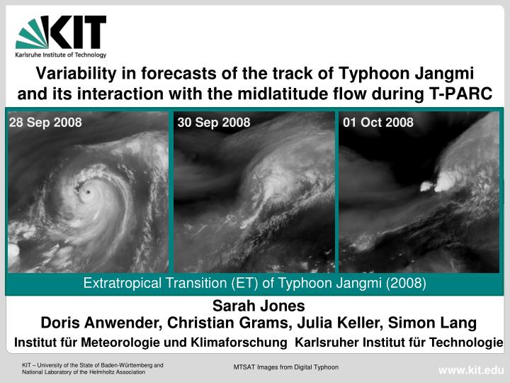
Variability in forecasts of the track of Typhoon Jangmi and its interaction with the midlatitude flow during T-PARC. 28 Sep 2008. 30 Sep 2008. 01 Oct 2008. Extratropical Transition (ET) of Typhoon Jangmi (2008). Sarah Jones Doris Anwender, Christian Grams, Julia Keller, Simon Lang

E N D
Variability in forecasts of the track of Typhoon Jangmi and its interaction with the midlatitude flow during T-PARC 28 Sep 2008 30 Sep 2008 01 Oct 2008 Extratropical Transition (ET) of Typhoon Jangmi (2008) Sarah Jones Doris Anwender, Christian Grams, Julia Keller, Simon Lang Institut für Meteorologie und Klimaforschung Karlsruher Institut für Technologie MTSAT Images from Digital Typhoon
ECMWF EPS Strike Probability Initialised 26 Sept 2008 00 UTC Initialised 26 Sept 2008 12 UTC
ECMWF Deterministic Forecast Verification for 30 Sept 00 UTC D-1 D-2 Analysis D-3 D-4
Jangmi flights during T-PARC Jangmi best track 20080923-20081001
THORPEX Interactive Grand Global Ensemble (TIGGE) Ensemble prediction system (EPS) containing 10 different ensemble forecasts from weather services world wide TIGGE: Ensemble forecast with up to 248 members Possibility to: Compare predictability for case in different EPS Get new scenarios as by using single EPS
TIGGE Tracks for Jangmi +12 +24 +36 +48 +56 +72 +84 +96 +108 +132 +120 +132 +144 +156 Track-Forecastfor TY Jangmi (TIGGE TC Track Data) IT: 2008-09-24, 12 UTC
TIGGE Tracks for Jangmi +12 +24 +36 +48 +56 +72 +84 +96 +108 +132 +120 +132 +144 +156 Track-Forecastfor TY Jangmi (TIGGE TC Track Data) IT: 2008-09-25, 12 UTC
TIGGE Tracks for Jangmi +12 +24 +36 +48 +56 +72 +84 +96 +108 +132 +120 +132 +144 +156 Track-Forecastfor TY Jangmi (TIGGE TC Track Data) IT: 2008-09-26, 12 UTC
+12 +24 +36 +48 +56 +72 +84 +96 +108 +132 +120 +132 +144 +156 Track-Forecast for TY Jangmi (TIGGE TC Track Data) IT: 2008-09-28, 12 UTC
Downstream variability in TIGGE Position of TY Jangmi in each ensemble member tracked using mslp 200 hPa ensemble std.dev. (40°-60°N) Forecasts from 2008-09-26, 12 UTC
4 from 10 TIGGE Clusters Initialization Time: 2008-09-26, 12 UTC Cluster Time: 2008-10-01, 12 UTC Clustertime Remnants of Jangmi
4 from 10 TIGGE Clusters 48 hrs later (2008-10-03, 12 UTC) Initialization Time: 2008-09-26, 12 UTC Cluster Time: 2008-10-01, 12 UTC merged Remnants of Jangmi
Operational COSMO forecasts during T-PARC at KIT Up to 16 forecasts per day on HP XC4000 at SCC Karlsruhe 2 domains 2 driving global models: GME (DWD) and IFS (ECMWF) 2 horizontal resolutions: 0.0625° and 0.025° 2 initial times: 00Z and 12Z 2.8km 2.8km 7.0km 7.0km COSMO forecasts duringT-PARC
3rd PANDOWAE Workshop, Bensheim-Auerbach - Christian Grams Outflow – Jet interaction 200 hPa wind COSMO-GME forecast 0.25°, BT 20080929 00UTC
Symposium „Klimasystem Nordatlantik“, Hamburg - Christian Grams 20080930 12UTC – 20080929 00UTC backward trajectories Criterion: ascent > 5000 m 2 PVU contour (blue-green shaded) 60 m/s contour Trajectories indicate advection of tropical air into the jet core Downstream development similar to ET of TS Lili (Agusti-Panareda, 2004) Interaction with low-level baroclinic zone and jet • geopotential and temperature at 1000 hPa VT 20080930 12UTC COSMO-GME forecast 0.25°, BT 20080929 00UTC COSMO-GME forecast 0.25°, BT 20080929 00UTC Thanks to PANDOWAE partners Heini Wernli for providing LAGRANTO and Maxi Boettcher for helping with the implementation Ph.D. Christian Grams
Singular Vectors targeted on Jangmi / Jet from 28.09.2008 00 UTC Moist Singular Vectors (Dry Norm) with TL159 Resolution (~ 1.2°) Position of Jangmi and Jet over Japan on 30.09.2008 00 UTC sensitive to both midlatitude flow and track and structure of Jangmi similar upstream structures Jangmi Shaded: vertically integrated total energy of leading five singular vectors Black: 500 hPa streamlines
28.09.2009 00 UTC + 24h 1 SV Total Energy and PV ~ 200 hPa 28.09.2009 00 UTC + 24h Wind ~ 200 hPa - Perturbation growth between TC outflow and midlatitude flow - Perturbations travel along PV Gradient
COSMO-GME vs. COSMO-IFS COSMO-GME COSMO-IFS +30h 6Z 30 Sep Jangmi moves faster towards Japan in COSMO-GME than in COSMO-IFS. T T +72h 0Z 2 Oct COSMO-GME: Jangmi reintensifies as extratropical system COSMO-IFS: Jangmi decays, new development downstream T T T
In both model runs new PV tower evolves in extratropical low. COSMO-GME vs. COSMO-IFS New PV tower 00 UTC 30 Sep 2008 COSMO-GME COSMO-IFS Both forecasts 0.25°, BT 20080929 00UTC new PV replaces old TC core. Early low-level new PV after 21 hrs, PV tower evolves after 30 hrs. new PV separated from old TC core. New PV tower evolves after 18 hrs
Falcon #22 20080930 00Z Source: http://cimss.ssec.wisc.edu Lidar and dropsondes COSMO wind speed along flight track T-PARC observations JMA upper air and radar network AMSU-a
Radar overlap in regions affected by ET rainfall → Calculation of horizontal wind field from radial Doppler winds JMA-Radar data during T-PARC TY Sinlaku 16Z 17 Sep 2008 TY Jangmi 14Z 30 Sep 2008
Summary • Large variability in track forecast – will ET occur? • Convection and new PV tower develops as Jangmi interacts with low-level baroclinic zone • Outflow from convection into midlatitude jet - jet accelerates • Uncertainty downstream: does downstream low develop from Jangmi or is it a new development? • Contrast to Sinlaku: baroclinic development vs. TC reintensification 28 Sep 2008 30 Sep 2008 01 Oct 2008