Download
1 / 51
510 likes | 659 Views
Environmental Planning and Historic Preservation (EHP) Compliance Workshop. EHP Compliance. Why is EHP Review Required?. The National Environmental Policy Act of 1969 (NEPA) requires that the Federal Government examine the proposed impacts of its actions before project implementation

E N D
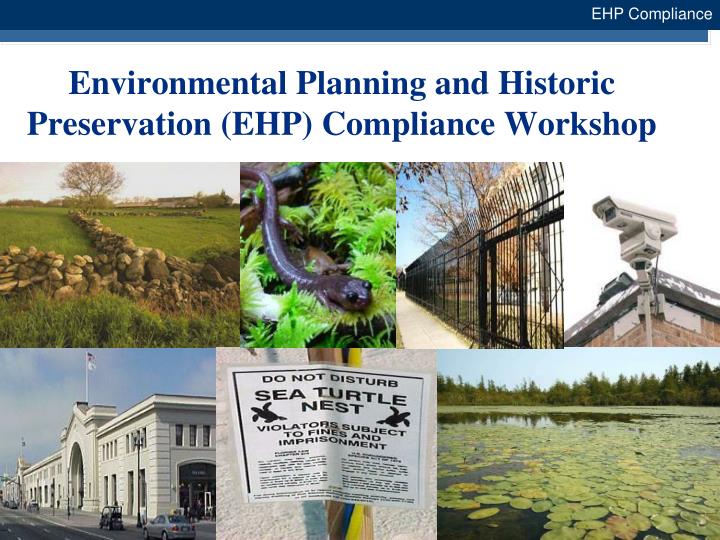
Environmental Planning and Historic Preservation (EHP) Compliance Workshop EHP Compliance
Why is EHP Review Required? • The National Environmental Policy Act of 1969 (NEPA) requires that the Federal Government examine the proposed impacts of its actions before project implementation • This applies to grant-funded actions • NEPA does not mandate preservation, only informed decision-making • NEPA serves as an “umbrella regulation” and provides a process which other EHP laws and regulations can be considered for the Grant Programs Directorate (GPD) • State processes cannot replace NEPA compliance. However, materials prepared for state compliance can be submitted with the EHP Review Packet • NEPA compliance have always been included in the special conditions of the grant award and the grant guidance
EHP Compliance What is an EHP Review? Analysis of pertinent project information to determine EHP compliance All projects funded with Federal grant dollars must comply with EHP laws, regulations, and Executive Orders and be certified by GPD Projects must receive EHP approval before initiation by GPD Grantees will provide all relevant EHP materials to GPD via the Centralized Scheduling and Information Desk - askcsid@dhs.gov Grant funds may be used for preparation of EHP documentation
EHP Compliance What are EHP Considerations? • Endangered Species • Cultural Resources • Historic properties • Archaeological sites • Air and Water Quality • Noise • Fish and Wildlife (including habitat) • Floodplains • Wetlands • Coastal Zones • Agricultural Lands • Environmental Justice • Socioeconomic Resources • Land Use • Hazardous Materials • Traffic • Geology (Topography, Soils)
EHP Compliance Completing the GPD EHP Screening Form: Use and Instructions Who needs to complete the form? What information is needed in order to complete the form? How much information is provided? Where is the information included on the form? When is the form submitted?
Case Study – Proposed Tower SiteHughes County, SD EHP Compliance 6 6
EHP Compliance EHP Review Packet Detailed project description Physical address of structure/facility or lat/long Clear color photographs (ground-level and aerial) Dimensions/acreage/square footage of structure and/or land affected
EHP Compliance EHP Review Packet (continued) • Extent and depth of ground disturbance for: • New construction and structure modification • Utility line placement • Fencing, light posts, installations, etc. • Height of communication towers • Explain the change in the overall height of the tower (if installation of antennas or communication equipment results in an increase in tower height) • Special equipment being used, staging areas, etc. • Year building or structure was built (to include buildings or structures that are in the vicinity)
A. PROJECT INFORMATION Grant Program Name: _______________________________ DHS Grant Award Number: __________________________ Project Name: ___________________________ Grant Fiscal Year: ___________ (Provide if no award number is available) EHP Compliance GPD EHP Screening Form: What Information is Needed? 9
GPD EHP Screening Form: What Information is Needed? A. PROJECT INFORMATION Grant Program Name: Homeland Security Grant Program (HSGP) DHS Grant Award Number: 2008-AB-C7-8910 Project Name: Hughes Tower Grant Fiscal Year: _____ (Provide if no award number is available) EHP Compliance 10 10
A. PROJECT INFORMATION (Continued)Project Type (Check all that apply): Physical security enhancements (i.e., installation of fencing, cameras, TWIC readers, bollards, motion detection systems, x-ray machines, lighting, etc.) New installation/construction/renovation (i.e., emergency operations centers, docks, piers, security guard buildings, etc.) Renovations/upgrades/modifications to structures 50 years old or older X Communication towers, related equipment, and equipment shelters Other ground disturbing activities (i.e., trenching, excavation, etc.) Training and exercises (specify whether classroom-based or field-based; field-based only require further information below) _____ Purchase of equipment (specify type, and whether mobile/ portable, or installation will be required) _______ Other (specify) ______________________________________________ EHP Compliance 11 11
Grantee Name: __________ Sub grantee Name: _________ State: ____ County: ___________ City: ________________ Agency: ______________________ Dollar value of grant (optional): _______ EHP Compliance A. PROJECT INFORMATION (Continued) 12
A. PROJECT INFORMATION (Continued) Grantee Name: Hughes County Emergency Management Agency Sub grantee Name: Hughes, LLC State: SD County: HughesCity: _______ Agency: _____________ Dollar value of grant (optional): EHP Compliance 13 13
B: PROJECT DESCRIPTION/LOCATION Enter Project Description: __________________________________________________________________________________________________________________________________________________________________________________________________________________________________________________________________________________________________ The project description should contain a brief summary of what specific action is proposed, where it is proposed, and how it will be implemented. EHP Compliance 14 14
B: PROJECT DESCRIPTION/LOCATION Enter Project Description: The Hughes County Emergency Management Agency, located in Hughes County, SD, proposes to construct a 480’ guyed communications tower on land owned by Hughes County. The proposed tower complex would include a 480’ guyed tower for which four micro-pile foundation holes must be dug at a depth of 30’ with a diameter of 1’, an emergency generator on a 4’ x 8’ concrete pad, and a 12’ x 9’ equipment shelter on a concrete pad. The entire compound would be enclosed with a chain link fence. (NOTE: If one project qualifies as multiple project types, then note and refer back to original entry.) EHP Compliance 15 15
Communication towers, related equipment and equipment shelters Project Location (physical project address or latitude/longitude of project location): _______________________________________________ Year existing building(s) or structure(s) involved in the proposed project was built (Required): __________ Color site photos attached (Required) Ground-level site photos (showing where installations are proposed): ___ Yes ___ No Aerial photograph with project limits outlined and with the location of any proposed installations identified (refer to Appendix A for guidance): ___Yes ___ No EHP Compliance B: PROJECT DESCRIPTION/LOCATION (Cont’d) 16
B: PROJECT DESCRIPTION/LOCATION (Cont’d) X Communication towers, related equipment and equipment shelters Project Location (physical project address or latitude/longitude of project location): 44° 24' 59"N, 99° 59' 1"W Year existing building(s) or structure(s) involved in the proposed project was built (Required): ____ Color site photos attached (Required) Ground-level site photos (showing where installations are proposed): X Yes ___ No Aerial photograph with project limits outlined and with the location of any proposed installations identified (refer to Appendix A for guidance): X Yes ___ No EHP Compliance 17 17
B: PROJECT DESCRIPTION/LOCATION (Cont’d) Communication towers, related equipment and equipment shelters (continued) Project Location (physical project address or latitude/longitude of project location): _______________________________________________ For projects involving antenna (e) installations on existing towers, provide the height of the existing tower and the height of the tower following the installation of the new antenna (e). For new projects, state the total height (in feet) of the communication tower or structure, including any antennae to be mounted: ______ If the proposed tower height is greater than 199 feet above ground level, state why this is needed to meet the requirements of the project: _____ EHP Compliance 18 18
B: PROJECT DESCRIPTION/LOCATION (Cont’d) X Communication towers, related equipment and equipment shelters (continued) Project Location (physical project address or latitude/longitude of project location): _______________________________________________ For projects involving antenna (e) installations on existing towers, provide the height of the existing tower and the height of the tower following the installation of the new antenna (e). For new projects, state the total height (in feet) of the communication tower or structure, including any antennae to be mounted: 480 feet If the proposed tower height is greater than 199 feet above ground level, state why this is needed to meet the requirements of the project: The tower height is required in order to provide adequate signal coverage throughout Hughes County. EHP Compliance 19 19
B: PROJECT DESCRIPTION/LOCATION (Cont’d) Communication towers, related equipment and equipment shelters (continued) Will the tower be free-standing or require guy wires? ____ Free standing ____ Guy wires If guy wires are required, state how many: _________ State why a guyed tower is needed to meet the requirements of this project: _____________________________ EHP Compliance 20 20
B: PROJECT DESCRIPTION/LOCATION (Cont’d) X Communication towers, related equipment and equipment shelters (continued) Will the tower be free-standing or require guy wires? ____ Free standing _X_ Guy wires If guy wires are required, state how many: 8 guy wires State why a guyed tower is needed to meet the requirements of this project: The tower is located in an area that is subject to severe weather, the guyed structure is more likely to remain standing and functioning in a storm event. EHP Compliance 21 21
B: PROJECT DESCRIPTION/LOCATION (Cont’d) Communication towers, related equipment and equipment shelters (continued) Has an FCC registration been obtained for this tower? ____Yes ____No Registration #: ___________ Has the FCC E106 process been completed? ____Yes ____ No Has the FCC TCNS process been completed? ____ Yes ____ No If yes, attach all relevant environmental documentation submitted as part of the registration process, including use of the Tower Construction Notification System (TCNS), if applicable. FRN#(Required) EHP Compliance 22 22
B: PROJECT DESCRIPTION/LOCATION (Cont’d) X Communication towers, related equipment and equipment shelters (continued) Has an FCC registration been obtained for this tower? _X_ Yes ____No Registration #: 1234567 Has the FCC E106 process been completed? _X_ Yes ____ No Has the FCC TCNS process been completed? _X_ Yes ____ No If yes, attach all relevant environmental documentation submitted as part of the registration process, including use of the Tower Construction Notification System (TCNS), if applicable. FRN#09876(Required) EHP Compliance 23 23
B: PROJECT DESCRIPTION/LOCATION (Cont’d) Communication towers, related equipment and equipment shelters (continued) Will ground disturbance be required? __ Yes (provide total extent (depth, length, and width) ___ No Has the ground been previously disturbed? (continued) ___Yes ___ No If yes, please describe the current disturbed condition of the area (i.e., parking lot, commercial development, etc.): _____ If no, include other visual documentation (see Appendix B for a list of online mapping resources): (See next slide) EHP Compliance 24
B: PROJECT DESCRIPTION/LOCATION (Cont’d) X Communication towers, related equipment and equipment shelters (continued) Will ground disturbance be required? X Yes (provide total extent (depth, length, and width) The fenced compound will measure 120’ x 80’, with two concrete pads measuring 4’x 8’ x 1’, and 12’ x 9’ x 1’. The micro-pile foundation holes will be 1’ in diameter at a depth of 30’, and the holes required to anchor the guy wires will be approximately 2’ x 2’ x 4’. Has the ground been previously disturbed? (continued) ___Yes X No If yes, please describe the current disturbed condition of the area (i.e., parking lot, commercial development, etc.): ________________ EHP Compliance 25 25
B: PROJECT DESCRIPTION/LOCATION (Cont’d) Communication towers, related equipment and equipment shelters (continued) If no, include other visual documentation (see Appendix B for a list of online mapping resources): Technical drawings/site plans (if available) ___ Yes ___ No FEMA Flood Insurance Rate Map (FIRM), with project limits outlined ___ Yes ___ No U.S. Fish and Wildlife Service, National Wetlands Inventory (NWI) Map, with project limits outlined ___ Yes ___ No U.S. Department of Agriculture (USDA) Soil Survey Map, with project limits outlined ___Yes ___ No EHP Compliance 26
B: PROJECT DESCRIPTION/LOCATION (Cont’d) X Communication towers, related equipment and equipment shelters (continued) If no, include other visual documentation (see Appendix B for a list of online mapping resources): Technical drawings/site plans (if available) X Yes ___ No FEMA Flood Insurance Rate Map (FIRM), with project limits outlined X Yes ___ No U.S. Fish and Wildlife Service, National Wetlands Inventory (NWI) Map, with project limits outlined ___ Yes X No U.S. Department of Agriculture (USDA) Soil Survey Map, with project limits outlined ___Yes X No EHP Compliance 27 27
B: PROJECT DESCRIPTION/LOCATION (Cont’d) Communication towers, related equipment and equipment shelters (continued) Will any equipment or structures need to be installed? ___ Yes ___ No If yes, please explain how and where this installation is proposed to be done (include site-specific photographs, and attach additional pages, if needed): ___________________________________ Will the equipment use the existing infrastructure for electrical distribution systems? ___ Yes ___ No EHP Compliance 28
B: PROJECT DESCRIPTION/LOCATION (Cont’d) X Communication towers, related equipment and equipment shelters (continued) Will any equipment or structures need to be installed? X Yes ___ No If yes, please explain how and where this installation is proposed to be done (include site-specific photographs, and attach additional pages, if needed): The compound will require the installation of fencing, the 480’ communication tower, an emergency generator and concrete pad, and an equipment shed and concrete pad. Will the equipment use the existing infrastructure for electrical distribution systems? X Yes ___ No EHP Compliance 29 29
B: PROJECT DESCRIPTION/LOCATION (Cont’d) Communication towers, related equipment and equipment shelters (continued) Are there any known structures or buildings that are 50 years old or older in the project area or immediate vicinity? (If yes, please provide the location of the structure(s), ground-level color photos of these structures, and identify their location(s) on the aerial map; see Appendix B for the web address of the National Register of Historic Places) ___ Yes ___ No Is there any previously completed environmental documentation for this project (i.e., environmental assessment, wetland delineation, archaeological study)? ___ Yes (please attach documentation) ___ No Is there any previously completed agency coordination for this project (i.e., correspondence with the U.S. Fish and Wildlife Service, State Historic Preservation Office, Tribal Historic Preservation Office)? ___ Yes (please attach documentation) ___ No EHP Compliance 30
B: PROJECT DESCRIPTION/LOCATION (Cont’d) X Communication towers, related equipment and equipment shelters (continued) Are there any known structures or buildings that are 50 years old or older in the project area or immediate vicinity? (If yes, please provide the location of the structure(s), ground-level color photos of these structures, and identify their location(s) on the aerial map; see Appendix B for the web address of the National Register of Historic Places) ___ Yes X No Is there any previously completed environmental documentation for this project (i.e., environmental assessment, wetland delineation, archaeological study)? ___ Yes (please attach documentation) X No Is there any previously completed agency coordination for this project (i.e., correspondence with the U.S. Fish and Wildlife Service, State Historic Preservation Office, Tribal Historic Preservation Office)? ___ Yes (please attach documentation) X No EHP Compliance 31 31
C: CONSIDERATION OF RESOURCE IMPACTS • Section C is not required for the following: • Purchase of mobile and portable equipment • Classroom-based training, or field exercises to be conducted at an existing facility having established procedures for that particular proposed exercise • Table Overview • Complete each of the rows and columns of the table as they pertain to the proposed project • Provide responses based on the latest planning and background information 32
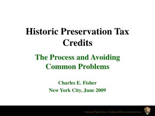
Ground-Level Photographs Ground-level photographs should show the installation location and context Copy the image, and paste it into Microsoft Paint, Microsoft Power Point, or graphics software Using the tools such as line drawing and fill colors, label exactly where project features will take place Cut and paste completed drawing into Word document and include explanatory text
Scenario: Hughes CountyGround Level Photograph #1 – Tower Site (facing west)
Scenario: Hughes CountyGround Level Photograph #1 – Tower Site (facing west) – Proposed Tower Footprint
Aerial Photographs • Obtain an aerial photo • There are multiple online sources for aerial photos • Some are free sources, others request a nominal fee • Copy the image, and paste it into Microsoft Paint, Microsoft Power Point, or graphics software • Using the tools such as line drawing and fill colors, label exactly where project features will take place • Cut and paste completed drawing into Word document and include explanatory text
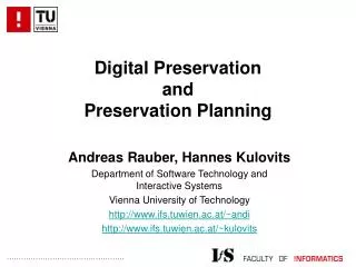
Topographic Maps • Topographic maps (“topo maps”) are created by the United States Geological Survey (USGS) and provide in-depth detail of surface features of the United States • Obtain a topo map • There are multiple online sources for topo map • Some are free sources, others request a nominal fee • Copy the image, and paste it into Microsoft Paint, Microsoft Power Point, or graphics software • Using tools such as line drawing and fill colors, label exactly where project features are proposed • Cut and paste completed drawing into the Word document and include explanatory text
Scenario: Hughes County Topographic Map – Identified and Labeled Proposed Project Area
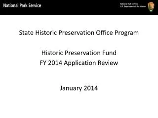
Floodplain Maps • FEMA maintains an online database of floodplain maps, referred to as FIRMs (Flood Insurance Rate Maps) • FEMA has smaller maps, FIRMettes, available to download for free • Go to www.msc.fema.gov, and enter your project location into “Product Search”, on the top left portion of the screen • Select the “View” icon for the resulting map • Select “Make a FIRMette”, and follow instructions to generate the FIRMette for your project area
Floodplain Maps (continued) Copy the image, and paste it into Microsoft Paint, Microsoft Power Point, or graphics software Using tools such as line drawing and fill colors, label exactly where project features are proposed Cut and paste completed drawing into the Word document and include explanatory text 41
Scenario: Hughes County Floodplain Map – Identified and Labeled P Proposed Project Area
Wetlands Maps • The US Fish and Wildlife Service created the National Wetlands Inventory (NWI) to assist with management, research, and planning • NWI maps are available online for free download at www.fws.gov/wetlands/Data/Mapper.html • NWI wetlands data is not comprehensive, but is a good starting point • Select the region you wish to view on the reference map, then select the “Locate” tab on the resulting map to zoom in to your project area • Select “Print PDF” to create your map
Wetlands Maps (continued) Copy the image, and paste it into Microsoft Paint, Microsoft Power Point, or graphics software Using tools such as line drawing and fill colors, label exactly where project features are proposed Cut and paste completed drawing into Word document and include explanatory text 44
Scenario: Hughes County Tower Wetlands Map – Identified and Labeled Proposed Project Area
EHP Compliance Projects Affecting Historic Properties Buildings and structures 50 years old or older may be listed on, or eligible for listing on, the National Register of Historic Places The State Historic Preservation Office (SHPO) should be consulted on projects that may impact listed or eligible properties, including archaeological resources (FEDERAL agency responsibility) An individual who meets the Secretary of the Interior’s Professional Qualification Standards must be used when determining the effects of a project on a historic property
EHP Compliance Programmatic Environmental Assessment 47 • GPD has developed a Programmatic Environmental Assessment (PEA) to examine the impacts of all its grant-funded projects • The PEA determined that certain types of projects would not have any impact on the environment • This includes, but is not limited to, PPE, medical supplies and limited pharmaceuticals, mobile and portable decontamination equipment, mobile and portable detection equipment, mobile and portable power equipment, and mobile and portable interoperable communications equipment • The PEA also defined those projects that would require further, case-by-case study
EHP Compliance Tips for a Timely EHP Review 48 Include clear color photos of where the actual equipment will be located Include any previous environmental documentation completed for the site with the EHP review packet Be sure to answer the questions what work is being proposed, where will it take place, and how will it be carried out? Look at AEL and PEA to assist in identifying projects that need EHP review
Frequently Asked Questions What do you mean by “date of construction”? Why do you need to know what is in the vicinity of my project? Where can I find my grant number? What do you mean by “total extent of ground disturbance”? What do you mean by “label photographs”?
EHP Compliance EHP Points of Contact