Download
1 / 1
10 likes | 88 Views
Youth and Geography: Utilizing Spatial Technologies to Aid in Post-Fire Vegetation Recovery and Research. Caitlin Chason, Project Coordinator; Steven Dasher, 4H Youth Development Advisor UC Cooperative Extension, 5555 Overland Ave, Suite 4101, San Diego, CA 92123.

E N D
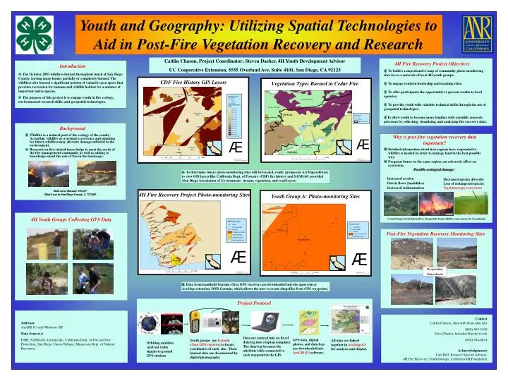
Youth and Geography: Utilizing Spatial Technologies to Aid in Post-Fire Vegetation Recovery and Research Caitlin Chason, Project Coordinator; Steven Dasher, 4H Youth Development Advisor UC Cooperative Extension, 5555 Overland Ave, Suite 4101, San Diego, CA 92123 4H Fire Recovery Project Objectives Introduction • To build a comprehensive map of community photo-monitoring sites fro m a network of local 4H youth groups. • To engage youth in leadership and teaching roles. • To offer participants the opportunity to present results to local agencies. • To provide youth with valuable technical skills through the use of geospatial technologies. • To allow youth to become more familiar with scientific research processes by collecting, visualizing, and analyzing fire recovery data. • The October 2003 wildfires burned throughout much of San Diego County, leaving many homes partially or completely burned. The wildfires also burned a significant portion of valuable open space that provides recreation for humans and wildlife habitat for a number of important native species. • The purpose of this project is to engage youth in fire ecology, environmental research skills, and geospatial technologies. Background • Wildfire is a natural part of the ecology of the county. Accepting wildfire as a normal occurrence and planning for future wildfires may alleviate damage inflicted to the environment. • Research on fire-related issues helps to meet the needs of the fire management community as well as adding to knowledge about the role of fire in the landscape. Why is post-fire vegetation recovery data important? • Detailed information about how regions have responded to wildfire is needed in order to manage land in the best possible way. • Frequent burns on the same region can adversely affect an ecosystem. Possible ecological damage: • To determine where photo-monitoring sites will be located,youth groups use ArcMap software to view GIS layers like California Dept. of Forestry (CDF) fire history and SANDAG provided (San Diego Association of Government) stream, vegetation, and road layers. Increased erosion Debris flows (landslides) Increased sedimentation Decreased species diversity Loss of endangered species Vegetation type conversion Total Acres Burned: 376,237 Total Acres in San Diego County: 2, 727,040 4H Youth Groups Collecting GPS Data Coastal Sage Scrub burned too frequently from wildfire can convert to Grasslands Post-Fire Vegetation Recovery Monitoring Sites Re-sprouting Native shrubs • Data from handheld Garmin eTrex GPS receivers are downloaded into the open source ArcMap extension, DNR Garmin, which allows the user to create shapefiles from GPS waypoints. Project Protocol ContactCaitlin Chason, chason@rohan.sdsu.edu (858) 495-5190 Steve Dasher, hsdasher@ucdavis.edu (858) 694-8874 Acknowledgements Carl Bell, Invasive Species Advisor; 4H Fire Recovery Youth Groups; California 4H Foundation SoftwareArcGIS 8.3 and Windows XP Data Source(s) ESRI, SANDAG, Garmin Int., California Dept. of Fire and Fire Protection, San Diego Union-Tribune, Minnesota Dept. of Natural Resources Data are entered into an Excel data log into a laptop computer. The data log becomes the attribute table connected to each waypoint in the GIS. GPS data, digital photos, and data logs are downloaded into ArcGIS 8.3 software. Youth groups use Garmin eTrex GPS receivers to locate coordinates of each site. These burned sites are documented by digital photography. All data are linked together in ArcMap 8.3 for analysis and display. Orbiting satellites send out radio signals to ground GPS stations