Download

1 / 37
370 likes | 518 Views
Long Term Biological Monitoring on the Upper Mississippi River: A Springboard For Broad-Scale, Multidisciplinary Investigations. David M. Soballe U.S. Geological Survey Upper Midwest Environmental Sciences Center. UMR PARTNERS. INHS. MPCA. USFWS. NPS. USEPA. Met.Council. IDNR. WDNR.

E N D
Long Term Biological Monitoring on the Upper Mississippi River: A Springboard For Broad-Scale, Multidisciplinary Investigations • David M. Soballe • U.S. Geological Survey • Upper Midwest Environmental Sciences Center
UMR PARTNERS INHS MPCA USFWS NPS USEPA Met.Council IDNR WDNR NAWQA LTRMP UMESC IEPA NASQAN USACOE NRP MoDC Districts USDA MDNR
UMR PARTNERS UMESC LTRMP Provides Foundation and Connecting Web for Big River Ecological Studies
LTRMP Part of the Environmental Management Program (EMP) • Established by Act of Congress in 1986 to counter effects of navigation • 2/3 EMP budget = Habitat Rehabilitation and Enhancement Program (HREP -USACOE) • 1/3 EMP budget = Long Term Resource Monitoring Program (LTRMP-USDOI) • USACOE given oversight responsibility
LTRMP Study Area: The Upper Mississippi River System (UMRS). Mississippi River mainstem between Ohio River and St. Paul, Minnesota, plus the Illinois River
The LTRMP is Multi-Disciplinary: Research, Monitoring, and Data Access • Fisheries • Water Quality • Aquatic and Floodplain Vegetation • Aquatic Invertebrates • Sedimentation and Bathymetry • Land Cover and Land Use • Data Delivery
LTRMP WQ Activity Driven by Resource Management • Detect changes in habitat availability and suitability • Assess normal variations and natural interactions among river biota and the physiochemical environment • Evaluate effects of human activities • Evaluate effects of watershed inputs • Link river biology to transport and transformation of nutrients and sediment
Upper Mississippi Resource Issues Cover a Broad Spectrum • nutrients • aquatic habitat • sedimentation • navigation • water supply • waste disposal • flood control • hydropower • recreation • water quality • toxic spills • migratory animals • hypoxia • sustainable agriculture • buffer zones • contaminants • biotic diversity • endangered species • native cultures • history & archaeology
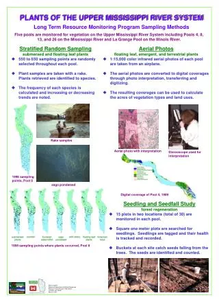
Two-Phase Approach to Limnological (WQ) Monitoring in LTRMP • Fixed site sampling (FSS) at permanent locations and fixed intervals (2- 4 weeks) • Stratified random sampling (SRS) conducted quarterly
Fixed Locations - Fixed Intervals • Permanent sampling locations (8-20) in each of 6 study reaches • Focus on short-term variations, watershed influences, downstream transformation and transport • 2 - 4 week sampling intervals • About 3,800 site visits per year
Stratified Random Sampling • Gives unbiased estimates of seasonal conditions in broad aquatic areas within the study reaches • Quarterly sampling in specific date windows • 2-5 sampling strata (probability sample) in each of 6 study reaches • 150 sites per episode, per study reach (3,600 site visits per year)
Water Quality Measurements • Total nitrogen • Ammonium • Nitrate + nitrite • Total phosphorus • Soluble reactive phos. • Dissolved Silica • Total suspended solids • Volatile suspended solids • Chlorophyll/phytoplankton • Ions : Ca,K,Mg,Na: Cl,SO4 • Sediment • Water depth • Secchi transparency • Ice and snow • Temperature • Dissolved oxygen • pH • Conductivity • Turbidity • Velocity
LTRMP WQ Provides Fundamental Limnological Information • Emphasis on biological aspects of water quality: nutrients, sediment, and physical limnology • 1993 to present: 7 study reaches (9 navigational pools, 40 tributaries) • Only source of current limnological data for much of Upper Mississippi River System
Program Resources Are Stretched • Over 1,000 river miles within the study area • Six field stations with staff • About $150 per site visit • 85,000 chemical measurements in 1999 • Lab & Field QA/QC = about 40% of total • about $2.50 per measurement (12% of WQ budget in LTRMP) • 30% reduction in effort in FY2000 • additional reductions likely.
LTRMP Supports Multiple Scales of Investigation and Collaboration • Whole Basin - Decades • River reaches (multiple years) • Individual locations (hours-years)
Total Nitrogen Flux in Pool 13 Input Output
unsuitable OK
UMR Collaborations Within USGS Are Well Established • LTRMP-UMESC-NRP • UMESC-LTRMP • LTRMP – NASQAN • LTRMP-Districts-NASQAN
LTRMP And NASQAN? • Differing objectives, differing design, but overlap in study areas and parameters • Collaborations in selected areas seem very promising • A more complete picture can be obtained in combination than in isolation
NASQAN: • Rating Curve approach • Long-term flux of many parameters • Broad spatial scale LTRMP: • Habitat and long-term biotic response in UMR • Short-term, spatially-varying events Differing Focus = Differing Design
Design Differences • NASQAN • Infrequent (monthly, quarterly) • Integrated, isokinetic channel cross-sections • Many parameters • Few locations (3-4 in UMR) • LTRMP • Frequent (biweekly, monthly, quarterly) • Discrete horizontal & vertical samples • Few transects, few vertical profiles • Fewer parameters • Many locations (about 1000)
Common Locations • Clinton • Grafton • Thebes
Comparability of Flux at Thebes Total Phosphorus Suspended Solids
Additional NASQAN-LTRMP Comparison and Collaboration Underway • Splitting samples between labs • Simultaneous sampling • Comparisons of existing data at Thebes, Grafton, and Clinton are progressing • Modelling to better cross-calibrate
EXAMPLE II: The Flood of 2001 • Combined BRD/WRD investigation • In-place capabilities allow this event to be monitored. • Combining expertise and sampling networks across divisions gives a more complete view. • See Poster
Combined Contributions • WRD and NASQAN: discharge records, lower Miss. and Ohio concentrations • WRD Iowa City: special flood monitoring, (Lagrangian) of concentrations. • BRD and LTRMP: flood concentrations by routine monitoring. • BRD and WRD – data analysis and interpretation, joint authorship of manuscript.
Preliminary Results • Spring flood (2001) substantially different from Spring-Summer Flood (1993) • Flood from uppermost basin (2001) unlike flood of entire region (1993). • 2001 flood volume was unremarkable below Thebes, but [NOx] was near records. • Lack of dilution from lower basin (Ohio) in 2001 sent high [NOx ] to the Gulf.
Thanks, Dave Soballe & Dennis Wasley WWW.UMESC.USGS.GOV
Primary LTRMP Products • Unique information for resource managers and decision makers on large rivers • High-quality, relevant data, in readily accessible and useable forms
Common Ground • Overlap in major water quality constituents measured. • Both address long-term temporal patterns in the Upper Mississippi River. • Data collected at overlapping locations. • Comparable measurements obtained to the extent allowed by differing objectives.