Download
1 / 2
30 likes | 180 Views
Figure 1. Attack on New Ulm during the Sioux Outbreak, August 19 th – 23 rd , 1862. Anton Gag (1859-1908). Figure 2. Refugees Camping on Prairie, Sioux Massacre, 1862. Adrian J. Ebell (1862). Figure 4. Execution of Dakota Indians, Mankato, Minnesota . J. Thullen (1884).

E N D
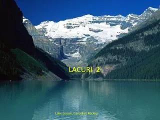
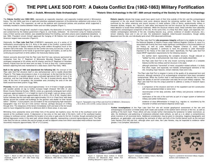
Figure 1. Attack on New Ulm during the Sioux Outbreak, August 19th – 23rd, 1862. Anton Gag (1859-1908). Figure 2. Refugees Camping on Prairie, Sioux Massacre, 1862. Adrian J. Ebell (1862). Figure 4. Execution of Dakota Indians, Mankato, Minnesota. J. Thullen (1884). Figure 6. Landowner-recovered military insignia, buttons, tack hardware, etc. THE PIPE LAKE SOD FORT: A Dakota Conflict Era (1862-1863) Military Fortification Mark J. Dudzik, Minnesota State Archaeologist "Historic Sites Archaeology in the US"; 68th annual meeting of the Society for American Archaeology The Dakota Conflict era (1862-1863), represents an especially important, and especially troubled period in Minnesota's history. The mid-1800s was time of rapid and relentless westward expansion of EuroAmerican settlement and culture in the nation and the state. This expansion, as well as the political and commercial policies and practices which supported it, inevitably resulted in clashes between Indian and non-Indian peoples (Figure 1). The Dakota Conflict, though brief, resulted in many deaths, the destruction of numerous homesteads (Figure 2), intervention and containment by the federal government (Figure 3), and finally, retribution. An internment camp for Dakota prisoners, many of them women and children, was established below Fort Snelling, and other prisons were established elsewhere. In late 1862, President Lincoln himself approved the hanging of 38 Dakota men accused of participating in the uprising - America's largest mass execution (Figure 4). Historic reports indicate that troops would have spent much of their time outside of the fort, and the archaeological component of the site would therefore exist some distance beyond the remaining earthen berm. This has been confirmed by the rather extensive and recent recovery of metal artifacts (100s of items), predominantly military in character (bullets, insignia, etc.; Figure 6), both within and beyond the sod fort structure (by the landowner, using a metal detector to locate these artifactual materials). While the structure remains intact, these activities have adversely impacted the archaeological component of the site. At the same time, it is likely that other, larger, and especially non-metallic archaeological elements of the site, including features (e.g., privies, evidence of wooden structures, etc.), remain relatively intact and in situ (of note, the landowner's targeted, metal-focused excavations, though widely dispersed over the site, are individually quite small; OSA observed/confirmed). The Pipe Lake Sod Fort site possesses integrity sufficient to be eligible for listing on the National Register of Historic Places under National Register Criterion A, since it is associated with events that have made significant contributions to the broad patterns of our history, as well as under National Register Criterion D, since, though archaeologically impacted, it continues to have the potential to yield information important to the history of the state and nation. Specifically, the Pipe Lake Sod Fort meets NRHP registration requirements for the following reasons: Historically, the Pipe Lake Sod Fort (21ME0031) represents one of a series of 12 fortifications constructed by the U.S. Army in the wake of the Conflict, a period which saw roving bands of Dakota Indians attacking white settlers throughout much of the southern half of the state. The reasons for the Conflict are many, but are due, in part, to perceived mistreatment at the hands of government agents and traders, as well as the continuing encroachment of white settlers into historically Dakota lands. Historic accounts document that the Pipe Lake Sod Fort was variously garrisoned by companies from the 1st Regiment of Minnesota Mounted Rangers (Pipe Lake contingent comprised of 35 cavalry and 30 infantry) and the 9th Regiment of Volunteer Infantry. Patrols from the fort were sent out daily "in front of (the) line". Communication between adjoining forts was maintained on a daily basis (Saint Paul Daily, 1863) Built in the spring of 1863 and abandoned the following fall, the remnant of the Pipe Lake Sod Fort structure itself is very well-preserved, and is readily discernible (Figure 5). This happy circumstance is due, in no small part, to the fact that the fort has been preserved in a woodlot adjacent to a cultivated agricultural field for most of its existence, and has had limited direct access. The site is located directly above Pipe Lake. At the time of occupation, the immediate area (including the area of the site itself) would have been prairie (Trygg 1964). Presently, the fort, which once stood approximately 1.8 m (≈ 6 feet) in height, possibly with wooden pickets on top to further increase height (Howard 1931:302; cf. also Brown County Historical Society, 1958:8), exists as a generally rectangular berm which measures approximately 0.7 m in height for much of its length. Laid out along a north-south axis, the fort measures approximately 50 m (N-S) x 35 m (E-W). Howard (ibid.) further indicates that the sod walls were approximately 0.9 m (≈ 3 feet) thick,"with deep ditches around the outside and buildings for the garrison and shelter for their horses within". "Ditches", if once present, are not evident on the accompanying high-resolution topographic map (0.2 foot [2.4 inch] contour interval), perhaps because of in-filling through time. The steepness of the terrain immediately north and west of the fort would seem to have mitigated the need for a defensive ditch in these areas, in any case. the earthen berm representing the complete structure, though reduced or "settled“ by time, is well-preserved, fully intact, and readily discernible; the Pipe Lake Sod Fort is the only known surviving example of a complete Dakota Conflict era military sod fort structure in the state; although selectively "harvested" of metal, occupation-related artifacts, it is likely that other, larger, and especially non-metallic archaeological elements of the site, including major features, remain relatively intact and in situ. The Pipe Lake Sod Fort is singular in terms of the quality of its preserved form and structure, although elements of its archaeological component have been somewhat compromised. While the Conflict itself is well-documented, relatively little is known about the details of sod fort construction and daily life at such military outposts. The Pipe Lake Sod Fort has the unique potential to address a variety of research topics including: a comparison of the structure and form of the expedient sod fort construction with more substantial timber or stone forts; reconstruction of the daily activities, both military and personal, evidenced at such forts; clarification of the role of the sod forts as part of a larger system of defensive military and settler fortifications; evidence of class differentiation in troops (e.g., regulars vs. volunteers) by the character of artifact and feature dispersal and/or type. Figure 5. Topographic map of Pipe Lake Sod Fort (21ME0031). Dimensions: = 50 m (N-S) x 35 m (E-W); contour interval: 0.2 foot. Further investigations of the Pipe Lake Sod Fort site will include geophysical assessment of the site and archaeological excavation of limited areas both inside and outside of the earthen berm remnant of the fort, as well as profiling of the berm itself. These efforts will also include further interviewing the landowner to better reconstruct, as able, the distribution and patterning of landowner-collected metal artifacts, as well as a to obtain a comprehensive photo inventory of all recovered items. Additional consideration may be given to relocating, mapping (topographic and geophysic, as applicable), and evaluating the remnants of other sod forts of the Conflict period (such as the remnant Lake Hanska [Fort Hill] sod fort), although other such sites, like Lake Hanska, may be expected to evidence rather greater, if not complete, disturbance. Mimicking more substantial stone and timber forts of the period, two bastions occur, the first at the southeast corner and second at the southwest corner. A depression or low area on the east side of the berm, north of the southeast bastion (midway to northeast corner), identifies the location of an entry or gate area for the fort. A similar, though somewhat less-well defined depression exists in the west wall, almost directly opposite, representing a second ingress/egress point. The Pipe Lake Sod Fort site as a whole (the sod fort proper as well as adjacent areas from which associated metal artifacts have been recovered) measures approximately 100 m2 (≈ 2.5 acres). Figure 3. Captured Sioux Indians in fenced enclosure On Minnesota River below Fort Snelling. Benjamin F. Upton (1862).