Download
1 / 32
330 likes | 412 Views
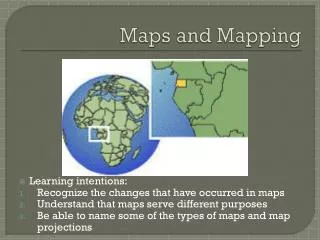
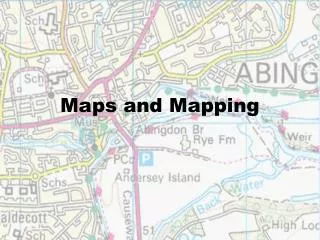
Maps and Mapping - First Six Weeks. I can define the words continent and ocean. I can identify the seven continents (North America, South America, Europe, Africa, Asia, Australia, Antarctica) on a map. I can identify the five oceans (Indian, Arctic, Atlantic, Pacific, Southern) on a map.

E N D
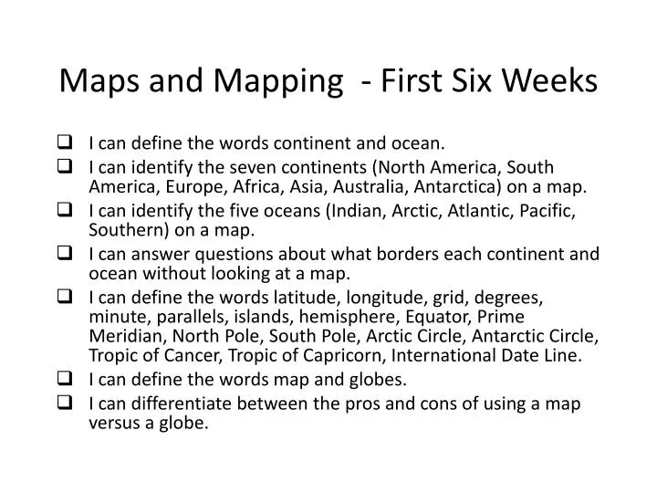
Maps and Mapping - First Six Weeks I can define the words continent and ocean. I can identify the seven continents (North America, South America, Europe, Africa, Asia, Australia, Antarctica) on a map. I can identify the five oceans (Indian, Arctic, Atlantic, Pacific, Southern) on a map. I can answer questions about what borders each continent and ocean without looking at a map. I can define the words latitude, longitude, grid, degrees, minute, parallels, islands, hemisphere, Equator, Prime Meridian, North Pole, South Pole, Arctic Circle, Antarctic Circle, Tropic of Cancer, Tropic of Capricorn, International Date Line. I can define the words map and globes. I can differentiate between the pros and cons of using a map versus a globe.
Maps and Mapping - First Six Weeks • I can recognize and differentiate between a Robinson map, Mercator map, Homolosine map, and Azimuthal map. • I can identify latitude lines (only) and degrees on a grid. • I can identify longitude lines (only) and degrees on a grid. • I can identify latitude and longitude lines (together) and degrees on a map. • I can locate the four hemispheres of Earth and identify which hemisphere(s) each continent belongs in. • I can identify where the Equator, Prime Meridian, North Pole, South Pole, Arctic Circle, Antarctic Circle, Tropic of Cancer, Tropic of Capricorn, International Date Line are located on a map and their degrees. • I can identify the major parts of a map (title, latitude lines, longitude lines, map key or legend, compass rose, scale, symbols). • I can answer questions in relation to using the parts of a map (title, latitude lines, longitude lines, map key or legend, compass rose, scale, symbols).
Maps and Mapping - First Six Weeks • I can use the scale bar to find distance on a map in miles and kilometers. • I can use the compass rose to determine directions and intermediate directions on a map (North, South, East, West, Northwest, Northeast, Southwest, Southeast). • I can recognize and distinguish among a climate, population, physical, political, topography, and land use and resource map. • I can define the words time zone, Greenwich, England, International Date Line. • I can explain why time zone maps are important. • I can recognize that each time zone equals fifteen degrees of latitude. • I can recognize the each time zone equals one hour and that Earth is divided into twenty four time zones.
Maps and Mapping - First Six Weeks • I can explain that time increases as a person moves to the east on a time zone. (add one hour) • I can explain that time decreases as a person moves to the west on a time zone. (subtract one hour) • I can determine what a bar graph is and its parts (title, x axis, y axis, similarities and differences of bars). • I can illustrate other ways to show information in chart form such as a table, time line, Venn Diagram, pie chart, line graph, etc. • I can practice using a bar graph and other graphs. • I can define the words population, gender, developed, developing, GDP, per capita GDP, life expectancy, and literacy rates. • I can realize that a population pyramid is the combination of two bar graphs into one. • I can read a population pyramid by looking at the males and females in a country by ages. • I can identify a country whose population is increasing, decreasing, and staying the same and make a correlation between population of a country and whether it is developed or developing.
Physical Geography – Part 1– Second Six Weeks • I can identify ways geography helps us understand our world. • I can define the words geography, environment, spatial, location, place, region, and three-dimensional. • I can identify the five themes of geography. • I can simulate and give examples for each of the five themes of geography. • I can differentiate between absolute and relative location. • I can differentiate between physical and human geography. • I can identify various physical regions of an area and define sub-region.
Physical Geography – Part 1– Second Six Weeks • I can identify possible push/pull factors and why people move from place to place. • I can identify possible causes and consequences of urbanization. • I can identify how people interact to their environment and why first peoples settled near water. • I can define the words urban, rural, and suburban. • I can give examples for each of the words urban, rural, and suburban. • I can define the words local, regional, and global. • I can give examples for each of the words local, regional, and global. • I can define the words globe, map, cartographer, surveyor, remote sensing, Landsat, GPS, GIS, database, and debris. • I can identify uses for Landsat, GPS, and GIS. • I can compare and contrast Landsat, GPS, and GIS.
Physical Geography – Part 1– Second Six Weeks • I can identify and compare the roles of a location analyst, climatologist, urban planner, volcanologist, oceanographer, etc. • I can define the word geomorphology and identify the connection with geography. • I can explain how Earth’s physical systems make life on Earth possible. • I can define the words magma, continent, tectonic plate, earthquake, Ring of Fire, volcano, weathering, erosion, sediment, and glacier. • I can illustrate and explain the role of each of the five layers of Earth. • I can identify the fourteen tectonic plates on Earth’s surface. • I can simulate the four types of tectonic plate movements and identify what landform or process is created from each movement. • I can differentiate between the tectonic plate theory and the continental drift theory. • I can define the word Pangaea.
Physical Geography – Part 1– Second Six Weeks • I can compare and contrast the two extreme events caused by internal forces (volcanoes and earthquakes). • I can compare and contrast the two external forces shaping the Earth (weathering and erosion). • I can illustrate and give real life examples of weathering. • I can illustrate and give real life examples of erosion. • I can define the words drainage basin, ground water, hydrologic (water) cycle, landform, plateau, relief, continental shelf, and atmosphere. • I can differentiate between fresh water and salt water. • I can define the words evaporation, condensation, precipitation, and runoff. • I can explain and illustrate the four steps of the water cycle. • I can differentiate between continental landforms and oceanic landforms. • I can give examples of continental landforms and oceanic landforms.
Physical Geography – Part 1– Second Six Weeks • I can define the words solstice, equinox, weather, climate, precipitation, vegetation region, savanna, and desert. • I can differentiate between Earth’s rotation, revolution, and tilt. • I can explain how the tilt of the Earth, its rotation, and revolution causes the four seasons in the Northern Hemisphere. • I can explain how the Southern Hemisphere is opposite of the Northern Hemisphere. • I can contrast the causes of weather versus the causes of climate such as solar energy and latitude. • I can identify and illustrate various climate and vegetation regions such as arid, semi arid, savanna, tropical, etc. • I can define the words global warming, greenhouse effect, greenhouse gas, fossil fuels, desertification, sustainable, carbon dioxide, emissions, and degraded.
Physical Geography – Part 1– Second Six Weeks • I can illustrate how the greenhouse effect can lead to global warming (climate change). • I can infer how global warming will impact the Earth physically such as massive flooding, etc. • I can identify possible real life solutions humans can apply to help stop and/ or reverse global warming. • I can evaluate how global warming (climate change), overgrazing, fragile soil, and deforestation leads\ to desertification. • I can identify possible real life solutions humans can apply to stop and/or reverse desertification.
Physical Geography Part 2– Third Six Weeks • I can differentiate between and give examples of primary and secondary landforms. • I can review the seven continents of Earth. • I can review why rivers and other water ways were important to the first civilizations. • I can memorize and identify on a map the four major landforms and bodies of water in North America (Rocky Mountains, Great Plains, Appalachian Mountains, and Mississippi River). • I can memorize and identify on a map the two major landforms and bodies of water in South America (Amazon River, Andes Mountains). • I can memorize and identify on a map the two major landforms and bodies of water in Africa (Nile River, Sahara Desert).
Physical Geography Part 2– Third Six Weeks • I can memorize and identify on a map the seven major landforms and bodies of water in Europe (Rhine River, Alps Mountains, Thames river, Seine River, Danube river, Ural Mountains, Volga River). • I can memorize and identify on a map the five major landforms and bodies of water in Asia (Euphrates river, Ganges river, Tigris River, Himalayas Mountains, Yellow river). • I can identify the six physical regions of Tennessee. • I can answer questions about geographical features of the six physical regions of Tennessee. • I can illustrate the six physical regions of Tennessee on a map from east to west and west to east. • I can define the words resources, renewable, and nonrenewable resources
Physical Geography Part 2– Third Six Weeks • I can differentiate between industrial, natural, and agricultural products or resources. • I can identify the three grand divisions of Tennessee (east, middle, west). • I can identify and illustrate on a map the major industrial and agricultural products found in Tennessee. • I can identify and illustrate on a map the three major rivers and river systems in Tennessee. • I can identify the five largest cities in Tennessee by population. • I can create a bar graph with an x and y axis showing the cities and population of the five largest cities in Tennessee. • I can plot the five cities on the bar graph and answer questions comparing and contrasting the cities.
Physical Geography Part 2– Third Six Weeks • I can define the words reapportionment, census, districts, Congress, population, and representation. • I can explain how the boundaries of Tennessee are based on population of the state and how each district has equal population. • I can differentiate between the Senate and House of Representatives. • I can explain how each state receives two senators to represent the state in Washington, D.C. • I can explain how the number of representatives in the House depends upon the population of the state.
Unit Four – Human Geography Part 1– Fourth Six Weeks • I can evaluate how natural resources affect a country’s population distribution and economy. • I can define the words population, birth rate, death rate, rate of natural increase, population density, urbanization, demographer, habitable lands, urban, and rural. • I can identify how the Earth’s population has increased over time due to better techniques in food production, discoveries in medical science, and improvements in sanitation. • I can compute how to find the rate of natural increase by subtracting the death rate from the birth rate and identify whether a country is increasing, decreasing, or staying the same in population. • I can define the words developed and developing countries, life expectancy, infant mortality, literacy rate, growth rate, family size, population distribution.
Unit Four – Human Geography Part 1– Fourth Six Weeks • I can identify characteristics of each type of country such as life expectancy rate, infant mortality rate, literacy rate, etc. • I can compare and contrast population of developed and developing countries. • I can infer how developed countries tend to have longer life expectancies but smaller populations due to better health care and urbanization. • I can infer how developing countries tend to have shorter life expectancies but larger populations due to a lack of health care and rural lifestyles. • I can infer possible negative and positive problems associated with a higher population on Earth. • I can identify how where people live is affected by one’s climate, elevation, and resources such as fertile soil and fresh water. • I can identify habitable and inhabitable lands on Earth.
Unit Four – Human Geography Part 1– Fourth Six Weeks • I can evaluate how larger populations on Earth live in habitable places more than inhabitable places. • I can explain how most of Earth is water and much of the land is inhabitable either too hot, too cold, too wet, or too dry. • I can explain how the earliest people were nomadic until they settled near water. • I can explain how once people settled near water and began to domesticate animals, civilizations rose. • I can identify how water is an important resource to the earliest civilizations providing food, transportation, trade, etc. • I can compare and contrast rural and urban areas. • I can evaluate how developed countries have larger urban populations and developing countries have larger rural populations. • I can infer possible positive and negative consequences to urbanization such as more cultural opportunities but more crime. • I can explain the distribution of people on Earth and show how more people today live near water and fertile soil and in the Northern Hemisphere
Unit Four – Human Geography Part 1– Fourth Six Weeks • I can calculate population density by dividing the population and finding how many people per square mile live in an area. • I can evaluate how population density is deceiving because some areas in a country may be heavily populated and other areas lightly populated. • I can explain how population density is better explained at a local region than a regional or global view. • I can define the words migration, immigrant, push factor, pull factor, culture, diversity, discrimination, refugee, persecution. • I can conjecture why people move from place to place. • I can categorize those reasons into push or pull factors. • I can further categorize the push and pull factors into environmental, political, economic, or cultural reasons and infer which is the factor most often the cause of migration. • I can compare and contrast internal and external migration.
Unit Four – Human Geography Part 1– Fourth Six Weeks • I can identify through history examples of internal and external migration such as the Irish potato famine, Great Migration, Great Depression of 1930s, Trail of Tears, etc. • I can evaluate positive and negative effects of migration such as diversity and discrimination (cultural), lack of resources such as fresh water, jobs, food, etc. (economic), and dangerous actions toward unwanted immigrants or refugees (political) • I can define the words natural resource, economy, economic system, command economy, market economy, GDP, export, import, specialization, raw material, barter system, tariffs, closed and emerging markets, supply and demand, inflation, recession, depression. • I can differentiate between the various types of natural resources: renewable, nonrenewable, and unlimited. • I can identify on a map possible renewable, nonrenewable, and unlimited resources. • I can categorize various resources into the appropriate category of renewable, nonrenewable, and unlimited. • I can infer how the more resources a place has the wealthier it probably is.
Unit Four – Human Geography Part 1– Fourth Six Weeks • I can compare the resources of developed and developing countries. • I can identify the four types of economic systems: traditional, command, market, and mixed. • I can compare and contrast the four types of economic systems. • I can simulate a traditional, command, and market economy through role plays. • I can identify on a map the countries of the United States, Russia, China, Mexico, India, Canada, and Great Britain. • I can identify and explain the type of economy that exists in the countries of the United States, Russia, China, Mexico, India, Canada, and Great Britain. • I can contrast Gross Domestic Product, per capita GDP, and the Gross National Product. • I can infer how developed countries will have a larger GDP, per capita GDP, and GNP than developing countries. • I can contrast imports and exports.
Unit Four – Human Geography Part 1– Fourth Six Weeks • I can explain how a country wants more exports than imports in order to be wealthy. • I can identify positive and negative consequences of specialization. • I can identify major economic issues on thematic maps, tables, diagrams, and charts. • I can contrast supply and demand and the law of supply and demand. • I can illustrate the concept of supply and demand through a role play. • I can compare and contrast recession and depression. • I can define the words government, citizen, representative democracy, monarchy, oligarchy, dictatorship, communism, autocracy. • I can identify the various types of governments: representative democracy or republic, parliamentary democracy, direct democracy, monarchy, oligarchy, dictatorship, communism, and autocracy. • I can compare and contrast a representative, parliamentary, and direct democracy.
Unit Four – Human Geography Part 1– Fourth Six Weeks • I can explain the major points of a democracy and identify democratic countries. • I can compare and contrast an autocracy, monarchy, and dictatorship. • I can explain the major points of an autocracy, monarchy, and dictatorship and identify countries which follow these governments. • I can define the word aristocracy and explain how it relates to an oligarchy. • I can compare and contrast an oligarchy and communism and identify countries which follow these governments. • I can identify the major government and leaders of the countries: India, Canada, Great Britain, Russia, China, and the United States. • I can identify various governance systems on a thematic map.
Unit Four – Human Geography Part 1– Fourth Six Weeks • I can infer the relationship between a government and its economic system such as most dictators enforce command economies. • I can identify personal and community responsibilities of citizens in a country for those under 18, over 18, and all ages of people. • I can differentiate between the rights of a citizen versus the rights of the government as well as the roles of a citizen. • I can read passages about countries and their various global issues such as health security, lack of resources, economic distress, and environmental issues and be able to identify causes, consequences, and solutions to these problems. • I can identify various international organizations such as TWS, UN, and ECOWAS and identify how they help solve economic, political, cultural, and environmental issues in the world.
Unit Five – Human Geography Part 2 – Fifth Six Weeks • I can evaluate how culture developed over time and how its shapes our lives. • I can define the words culture, anthropologist, ethnic group, religion, language, language family, and missionary. • I can explain how culture is learned. • I can identify which groups of people influence a person’s culture such as family first, then friends, school, media, government, and religious institutions. • I can describe activities that I was taught directly or observed in others such as language, way I dress, etc. • I can identify the elements of culture such as language, religion, food, clothing, beliefs, traditions, technology, government, and arts and crafts, etc. • I can explain how culture is everything about a person the way they brush their teeth to their language, religion, government, etc.
Unit Five – Human Geography Part 2 – Fifth Six Weeks • I can identify the five major types of religion: Buddhism, Christianity, Hinduism, Islam, and Judaism. • I can identify the major beliefs of these religions such as basic beliefs, teacher, and adherents. • I can explain how religion has spread to other places due to missionaries and traders. • I can compare and contrast a religion map and language map and infer how trade and conquest not only affected the religion of an area but the language as well. • I can identify major languages and language families. • I can infer which language families are the largest and possible reasons why. • I can infer which language families are shared by different continents and possible reasons why. • I can infer how societies might have conflict if there are differences in languages.
Unit Five – Human Geography Part 2 – Fifth Six Weeks • I can evaluate how language has spread over time and how it has changed over time. • I can define exploration and give examples of people exploring. • I can define colonization and give examples of colonies. • I can identify in history examples of people forcing others to practice their religion or speak their language such as the Spanish and English era of exploration and colonization. • I can identify how words have changed over time in spelling and meaning such as weblog to blog. • I can define the words agricultural revolution, innovation, technology, diffusion, cultural hearth, domestication, nomad.
Unit Five – Human Geography Part 2 – Fifth Six Weeks • I can identify the lifestyle of a nomad. • I can explain how cultures change over time sometimes slowly or very rapidly. • I can explain the shift of humans gathering food to raising food due to the agricultural revolution. • I can define the word innovation. • I can identify how cultures have changed over time due to different innovations such as clay pots or leather bags or telegraphs to the telephones to computers etc. • I can explain how technology changes a culture and can help people meet their basic needs easier. • I can explain how domestication of plants and animals helped the nomadic people to settle in places for longer periods of time. • I can explain how domestication and development of agriculture helped people leave the nomadic life to become farmers and later merchants and traders. • I can explain how domestication and innovations also lead to the creation of civilizations because nomadic people began to settle in one place and build cities.
Unit Five – Human Geography Part 2 – Fifth Six Weeks • I can identify examples of diffusion throughout history and today such as use of written language, coins, new ideas, religion, and fast-food restaurants and cell phones. • I can explain and identify on a map examples of cultural hearths. • I can define the basic needs of food, clothing, and shelter and give examples. • I can infer how these cultural hearths were usually near water or mountains so that they could meet their basic needs easier. • I can explain how diffusion is much easier today through the use of the Internet and other technology than thousands of years ago. • I can explain how some people in society refuse to accept cultural change and technology such as the Amish. • I can identify in history how some people are forced to accept cultural change such as the Native Americans or the native peoples of the Americas during the age of exploration.
Unit Six – Human Geography Part 3– Fifth and Sixth Six Weeks • I can define the words monotheistic, polytheistic, Siddhartha Guatama, Jesus Christ, Moses, salvation, Koran (Quran), Nirvana, Muhammad, Torah, adherents, Allah, Brahman, Ten Commandments, Bible, Muslims, deity, and Yahweh. • I can explain how religion affects the way people speak, dress, what they eat, etc. and is a major force in a person’s everyday life. • I can create a map with a title, map key, and symbols showing the five major religions of the world. • I can answer questions about a map showing the five major religions of the world. • I can create a pie chart with a title, symbols, colors, and key showing the percentages of the number of followers of each religion. • I can create a bar graph with a title, symbols, colors, x and y axis, and key showing the number of followers (adherents) of each religion.
Unit Six – Human Geography Part 3– Fifth and Sixth Six Weeks • I can explain the major beliefs of the five major religions. • I can identify the holy book, holy day, religious founder, religious leader or clergy, followers, and god(s) of the five major religions. • I can categorize each religion as monotheistic, polytheistic, or neither. • I can define the words Semitic and Indian. • I can categorize each religion as Semitic or Indian. • I can compare and contrast the Semitic religions of Judaism, Christianity, and Islam. • I can compare and contrast the Indian religions of Buddhism and Hinduism. • I can answer questions about the five major religions using maps, charts, and graphs.
Unit Seven – Physical and Human Geography - Country Study - Sixth Six Weeks • I can identify geographical features about my country such as latitude, longitude, capital city, borders, mountains, rivers, deserts or plateaus, climate, wildlife, and vegetation. • I can evaluate why certain wildlife and vegetation is indigenous to my country due to its latitude position and explain why. • I can identify cultural features about my country such as traditional clothing, traditional food, language, religion, music, flag, traditional housing, and customs. • I can evaluate how life is like for the people in my country on a daily basis. • I can identify demographical features about my country such as population, area in square miles, birth rate, death rate, growth rate, infant mortality rate, population distribution, population density, literacy rate, life expectancy rate, and poverty rate
Unit Seven – Physical and Human Geography - Country Study - Sixth Six Weeks • I can infer based on its features if my country is developed or developing and explain why. • I can identify historical features of my country such as its early history, independence, recent events, imports, exports, GDP, government, and governmental features. • I can explain the economic system of my country and infer how the economy and government relate such as a country usually has a command economy and a dictator as leader. • I can illustrate facts about my country through many projects such as creating maps, charts, brochures, graphs, menus, etc.