Download
1 / 90
1.02k likes | 1.26k Views
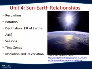
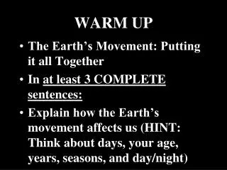
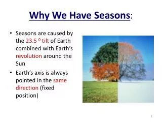
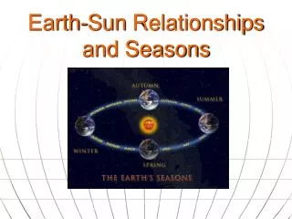
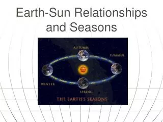
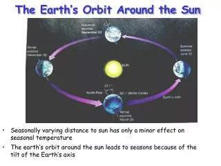
Earth’s Tilt and Seasons. Axis : imaginary line that passes through Earth’s center and the North & South Poles Earth’s axis tilt = 23.5° causes Earth’s seasons causes ‘length’ of day to change throughout the year. 23.5°. 23.5°. Plane of orbit. Rotation :

E N D
Earth’s Tilt and Seasons
Axis: • imaginary line that passes through Earth’s center and the North & South Poles • Earth’s axis tilt = 23.5° • causes Earth’s seasons • causes ‘length’ of day to change throughout the year
23.5° 23.5° Plane of orbit
Rotation: • Earth’s spinning onits axis • causes night & day • Earth rotates every 24 hours
Revolution: • movement of one object around another • Earth revolves around the sun every 365.25 days
Orbit: • an object’s path as it revolves around another object • Earth’s orbit around the sun is slightlyelliptical, not perfectly circular
When we are tilted toward the sun, we have summer. • When we are tilted away from the sun, we have winter
23.5° 23.5° Plane of orbit
Equator: imaginary line encircling the Earth like a belt at 0° latitude • All lines of latitude are measured as north or south of the equator. Label your map!
Tropic of Cancer: latitude 23.5° N Tropic of Capricorn: latitude 23.5°S Label your map!
Arctic Circle: latitude 66.5° N Antarctic Circle: latitude 66.5°S Label your map!
Solstice: 2 days of the year when the noon sun is directly overhead at either 23.5° S or 23.5° N • Summer: longest “day” of year (daylight) • Around June 21st • Winter: shortest “day” of year (daylight) • Around Dec. 21st
Equinox: 2 days of the year when the noon sun is directly overhead at the equator (equal amt. of day & night) • Vernal (spring) • Around March 21st • Autumnal (fall) • Around Sept. 21st
Copy this diagram into your notes. Seasons simulator
Climate & Global Wind Patterns
Weather: current condition of Earth’s atmosphere at a particular time & specific place
Climate: average weather over a long period of time (decades/centuries)
Because sun’s rays strike earth at different angles, we have unequal heating of the earth’s surface
Two factors that influence climate • Temperature • Precipitation
4 Factors influencing a climate’stemperatures • Latitude • Altitude • Distance from water • 4. Ocean currents
Latitude: • distance on a map measured north & south of the equator in degrees Polar Label your map! GAH! The spelling on this illustration is terrible. Stupid internet! Polar
3 BASIC CLIMATE ZONES • A. Tropical zone = HOT • near equator • b/t Tropic of Cancer (23.5°N) • and • Tropic of Capricorn (23.5°S)
Tropic of Cancer (23.5N) Tropic of Capricorn (23.5S) Label your map!
B. Temperate zones (2 ) have seasons, not always hot or cold b/t Tropic of Cancer (23.5°N) and Arctic Circle (66.5°N) and b/t Tropic of Capricorn (23.5°S) and Antarctic Circle (66.5°S)
Arctic Circle (66.5N) Tropic of Cancer (23.5N) Tropic of Capricorn (23.5S) Antarctic Circle (66.5S) Label your map!
C. Polar zones (2) = COLD b/t Arctic Circle (66.5°N) and North Pole (90°N) and b/t Antarctic Circle (66.5°S) and South Pole (90°S)
Arctic circle (66.5N) Antarctic circle (66.5S) Label your map!
2. altitude: distance above earth’s surface; measured from sea level higher altitudes = cooler temps. Mt. Kilimanjaro latitude = 3°S
3. distance from LARGE bodies of H2O (oceans or inland seas) closer to H2O = more moderate climate
4. ocean currents: • flow of water in a particular direction in the ocean • warm currents carry warm H2O; • cold currents carry cold H2O
Gulf Stream: warm H2O ocean current starts at tip of Floridaand warms eastern U.S. & western Europe
desert H2O Copy this diagram to show windward (wet) & leeward (dry) sides of mountain
2. prevailing winds: winds that blow in one general direction Aerosols in the atmosphere (video)
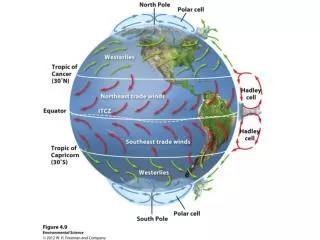
a. Trade winds • flow toward equator from about 30°N & 30°S latitude • blow from the east to the west • can bring storms like hurricanes across the ocean from Africa to the U.S. • used by trading ships to quickly get across the ocean from Europe to the New World
Label your map! 60°N 30°N 0° 30°S 60°S
b. Westerlies • blow between 30 ° and 60 ° latitude in both the N and S hemispheres • move from west to east • move weather across the U.S. and Canada
http://www.ssec.wisc.edu/data/us_comp/movie-large.php 60°N 30°N 0° 30°S 60°S
c. Polar Easterlies • Dry and extremely cold air from the poles • Flow between the poles and the Westerlies, in both N and S hemispheres. • Blow from east to west
Label your map! 60°N 30°N 0° 30°S 60°S
60°N 30°N 0° 30°S 60°S
The Coriolis Effect • caused by earth's rotation, currents seem to: • turn clockwise in theNorthern Hemisphere • turn counterclockwisein the Southern Hemisphere. • influences the direction of winds & ocean currents around the world
Meteorology Weather you like it or not! (4m) National Geographic.com Weather 101