Download
1 / 24
380 likes | 774 Views
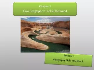
How Geographers look at the world. Chapter 1. Chapter 1, Section 1. Globes and Maps: Projections Determining Location: Latitude Longitude Global Grid (absolute location) Hemispheres Reading a Map Physical Maps Political Maps Thematic Maps. Globes and Maps.

E N D
How Geographers look at the world Chapter 1
Chapter 1, Section 1 • Globes and Maps: Projections • Determining Location: • Latitude • Longitude • Global Grid (absolute location) • Hemispheres • Reading a Map • Physical Maps • Political Maps • Thematic Maps
Globes and Maps • The Earth is a 3-Dimensional sphere. We also call this a globe. • A map is 2-Dimensional. A map allows us to make sense of a 3-D globe on a 2-D piece of paper.
Longitude and Latitude • We use longitude and latitude to determine location • Together they make up the grid system. A grid is a box (square) on a map. • For latitude, think “flat” lines • The Equator is a line of latitude. It is zero degrees latitude. • For longitude, think “long” lines • The Prime Meridian is a line of longitude. It is zero degrees longitude.
Great Circle routes • Going from Miami to London • A straight line on a map is not the fastest route. • A straight line on a globe is the fastest route. • When you draw a straight line on a globe, it appears to bend on a map
Projections: Planar Projection • When the Earth just looks like a circle • Most accurate at the center. The further out we look, the more elongated things get • Think “Plane” (a flat surface)
Projections: Cylindrical Projection • When the globe is turned into a rectangle • Most accurate at the equator, and least accurate at the poles • Antarctica is not that big • Think “Cylinder”
Projections: Conic Projection • Similar to a planar projection • More accurate when indicating distances and directions • Think “Cone”
Other Projections WinkelTripel Projection Goode’s Projections Mercator Projection Robinson Projection
Hemispheres • The Earth is divided into four hemispheres: • Northern Hemisphere • Southern Hemisphere • Eastern Hemisphere • Western Hemisphere
Reading a Map Compass Rose Cardinal Directions Intermediate Directions Scale Bar Key Boundary Lines Cities/Capitals
Small-Scale Maps, Large-Scale Maps Small-Scale Map Large-Scale Map In a small-scale map, the Eiffel Tower looks small. In a large-scale map, the Eiffel Tower looks large
Maps • There are three main types of maps: • Physical Maps: which shows Earth’s physical features (lakes, mountains, etc.) • Political Maps: which shows boundaries, cities, and states (helps with politics) • Thematic Maps: which is basically every other type of map. These maps have themes, and can help illustrate anything.
Thematic Map Qualitative Map: symbols and colors Flow-line Map: illustrate movement
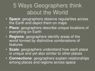
Chapter 1, Section 2 • Why is it important to understand geography? • Elements of Geography • Absolute Location and Relative Location • Place and Regions • Physical Systems and Human Systems (pretty much what this class is about) • Research Methods • The Bigger Picture of Geography • Geography as a Career
Elements of geography • Absolute Location: Exactly where something is located. • Global Address • Relative Location: Where something is compared to where something else is.
Place and regions • Place: A particular space • Regions: Areas with similar characteristics • Formal Region: A region that has a common characteristic throughout • The Great Plains • Remembering: Collegiate Greeks want to throw a “Formal” in The Great Plains • Functional Region: A region that has a central place, with surroundings linked to it • Pretty much any city in the world (Metropolis and the suburbs) • Remembering: Washington, D.C. is dys”function”al • Perceptual Region: A region based on perception (ideas and feelings) • The Bible Belt • What is your “perception” of the South?
Physical Systems and human Systems • Physical Geography: Earth’s physical features • What does the Earth look like here? • An ecosystem is a community of plants and animals that depend on one another for survival • Human Geography: Earth’s cultural features • What do the people do here? What do they eat? • Movement: The spread of people, goods, and ideas • Human-environment interaction: exactly what the name suggests.
Research methods • Direct Observation: look around • Mapping: How do you illustrate the land on paper? You make a map. Designing and making maps = cartography • Interviewing: asking people questions about what they know. • You get dropped off in the middle of Africa. You don’t really know where you are, but there are a lot of people. What do you do? • Bizarre Foods • Analyzing Statistics: the easiest way for us to learn about another place • Rainfall, average temperature, etc. • Using Technology: Combining statistics with technology paints an even better picture • Geographic Information Systems (GIS): computer tools that process and organize data and satellite images with other types of information gathered by geographers and scientists
Geography: The Bigger Picture Geography has an effect on: • Past Environments: What did Florida look like 1 million years ago? • Politics: John Boehner’s opinion on global warming • Society and Culture: A society and its culture is largely based on its surroundings • Economies: How are locations chosen for economic activities?