Download
1 / 1
10 likes | 131 Views
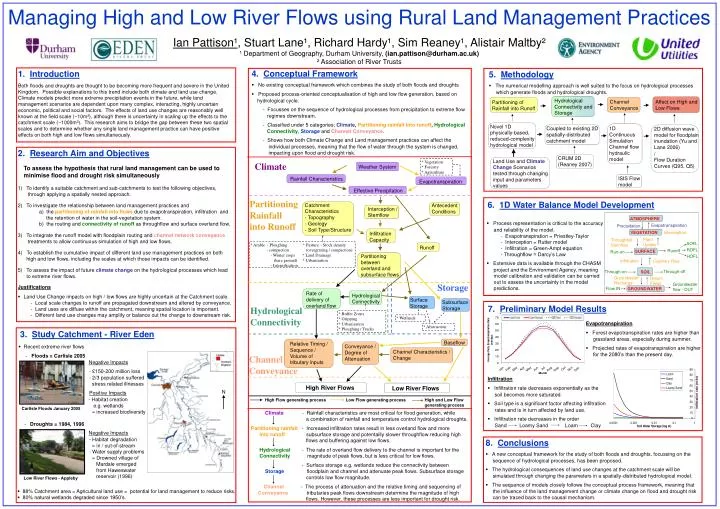
Managing High and Low River Flows using Rural Land Management Practices Ian Pattison ¹ , Stuart Lane ¹ , Richard Hardy ¹ , Sim Reaney ¹ , Alistair Maltby ² ¹ Department of Geography, Durham University, (ian.pattison@durham.ac.uk) ² Association of River Trusts. 4. Conceptual Framework

E N D
Managing High and Low River Flows using Rural Land Management Practices Ian Pattison¹, Stuart Lane¹, Richard Hardy¹, Sim Reaney¹, Alistair Maltby² ¹ Department of Geography, Durham University, (ian.pattison@durham.ac.uk) ² Association of River Trusts • 4. Conceptual Framework • No existing conceptual framework which combines the study of both floods and droughts • Proposed process-oriented conceptualisation of high and low flow generation, based on hydrological cycle. - Focusses on the sequence of hydrological processes from precipitation to extreme flow regimes downstream. - Classified under 5 categories; Climate, Partitioning rainfall into runoff, Hydrological Connectivity, Storage and Channel Conveyance. - Shows how both Climate Change and Land management practices can affect the individual processes, meaning that the flow of water through the system is changed, impacting upon flood and drought risk. 1. Introduction Both floods and droughts are thought to be becoming more frequent and severe in the United Kingdom. Possible explanations to this trend include both climate and land use change. Climate models predict more extreme precipitation events in the future, while land management scenarios are dependent upon many complex, interacting, highly uncertain economic, political and social factors. The effects of land use changes are reasonably well known at the field scale (~10m²), although there is uncertainty in scaling up the effects to the catchment scale (~1000m²). This research aims to bridge the gap between these two spatial scales and to determine whether any single land management practice can have positive effects on both high and low flows simultaneously. • 5. Methodology • The numerical modelling approach is well suited to the focus on hydrological processes which generate floods and hydrological droughts. Weather System Rainfall Characteristics Evapotranspiration Effective Precipitation Catchment Characteristics - Topography - Geology - Soil Type/Structure Antecedent Conditions Interception / Stemflow 2D diffusion wave model for floodplain inundation (Yu and Lane 2006) / Flow Duration Curves (Q95, Q5) • 2. Research Aim and Objectives • To assess the hypothesis that rural land management can be used to minimise flood and drought risk simultaneously • To identify a suitable catchment and sub-catchments to test the following objectives, • through applying a spatially nested approach. • To investigate the relationship between land management practices and • a) the partitioning of rainfall into flows due to evapotranspiration, infiltration and • the retention of water in the soil-vegetation system. • b) the routing and connectivity of runoff as throughflow and surface overland flow. • To integrate the runoff model with floodplain routing and channelnetwork conveyance • treatments to allow continuous simulation of high and low flows. • 4) To establish the cumulative impact of different land use management practices on both • high and low flows, including the scales at which those impacts can be identified. • To assess the impact of future climate change on the hydrological processes which lead • to extreme river flows. • Justifications • Land Use Change impacts on high / low flows are highly uncertain at the Catchment scale. - Local scale changes to runoff are propagated downstream and altered by conveyance. - Land uses are diffuse within the catchment, meaning spatial location is important. - Different land use changes may amplify or balance out the change to downstream risk. Infiltration Capacity Land Use and Climate Change Scenarios tested through changing input and parameters values * Vegetation * Forestry * Agriculture Runoff Climate CRUM 2D (Reaney 2007) Partitioning between overland and subsurface flows High Flow generating process Low Flow generating process High and Low Flow generating process Partitioning of Rainfall into Runoff Hydrological Connectivity and Storage Affect on High and Low Flows ISIS Flow model Channel Conveyance 6. 1D Water Balance Model Development Partitioning Rainfall into Runoff Novel 1D physically-based, reduced-complexity hydrological model Coupled to existing 2D spatially-distributed catchment model Rate of delivery of overland flow Hydrological Connectivity Surface Storage Subsurface Storage • Process representation is critical to the accuracy and reliability of the model. - Evapotranspiration = Priestley-Taylor - Interception = Rutter model - Infiltration = Green-Ampt equation - Throughflow = Darcy’s Law • Extensive data is available through the CHASM project and the Environment Agency, meaning model calibration and validation can be carried out to assess the uncertainty in the model predictions. 1D Continuous Simulation Channel flow hydraulic model ATMOSPHERE Evapotranspiration Precipitation * Arable - Ploughing * Pasture – Stock density • - compaction (overgrazing / compaction) • - Winter crops * Land Drainage • (bare ground) * Urbanisation • - Intensification VEGETATION Interception Plant Uptake Throughfall / Stemflow SOFL Baseflow Relative Timing / Sequence / Volume of tributary inputs ROFL Conveyance / Degree of Attenuation Runoff SURFACE Run-on Channel Characteristics / Change HOFL Infiltration Capillary Rise Through-off Through-on SOIL Storage Groundwater flow - OUT Groundwater Recharge Return Flows Flow IN High River Flows GROUNDWATER Low River Flows 7. Preliminary Model Results Hydrological Connectivity * Buffer Zones * Gripping * Urbanisation * Ploughing / Tracks * Wetlands • Evapotranspiration • Forest evapotranspiration rates are higher than grassland areas, especially during summer. • Projected rates of evapotranspiration are higher for the 2080’s than the present day. * Abstraction 3. Study Catchment - River Eden • Recent extreme river flows - Floods = Carlisle 2005 Negative Impacts • - £150-200 million loss • - 2/3 population suffered • stress related illnesses • Positive Impacts • - Habitat creation • e.g. wetlands • = increased biodiversity • - Droughts = 1984, 1996 • Negative Impacts • - Habitat degradation • = in / out-of-stream • - Water supply problems • = Drowned village of • Mardale emerged • from Haweswater • reservoir (1996) Channel Conveyance • Infiltration • Infiltration rate decreases exponentially as the soil becomes more saturated. • Soil type is a significant factor affecting infiltration rates and is in turn affected by land use. • Infiltration rate decreases in the order Sand Loamy Sand Loam Clay N Climate - Rainfall characteristics are most critical for flood generation, while a combination of rainfall and temperature control hydrological droughts. Partitioning rainfall - Increased infiltration rates result in less overland flow and more into runoff subsurface storage and potentailly slower throughflow reducing high flows and buffering against low flows. Hydrological - The rate of overland flow delivery to the channel is important for the Connectivity magnitude of peak flows, but is less critical for low flows. - Surface storage e.g. wetlands reduce the connectivity between Storage floodplain and channel and attenuate peak flows. Subsurface storage controls low flow magnitude. Channel - The process of attenuation and the relative timing and sequencing of Conveyance tributaries peak flows downstream determine the magnitude of high flows. However, these processes are less important for drought risk. Carlisle Floods January 2005 • 8. Conclusions • A new conceptual framework for the study of both floods and droughts, focussing on the sequence of hydrological processes, has been proposed. • The hydrological consequences of land use changes at the catchment scale will be simulated through changing the parameters in a spatially-distributed hydrological model. • The sequence of models closely follows the conceptual process framework, meaning that the influence of the land management change or climate change on flood and drought risk can be traced back to the causal mechanism. Low River Flows - Appleby • 88% Catchment area = Agricultural land use = potential for land management to reduce risks. • 80% natural wetlands degraded since 1950’s.