Download
1 / 51
530 likes | 587 Views
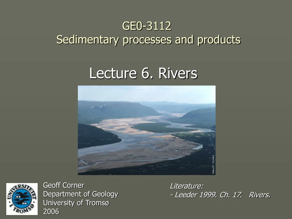
Lecture 6. Rivers. GE0-3112 Sedimentary processes and products. Geoff Corner Department of Geology University of Tromsø 2006. Literature: - Leeder 1999. Ch. 17. Rivers. Contents. 6.1 Introduction – importance of fluvial systems 6.2 Fluvial channels 6.3 Floodplains

E N D
Lecture 6. Rivers GE0-3112 Sedimentary processes and products Geoff Corner Department of Geology University of Tromsø 2006 Literature: - Leeder 1999. Ch. 17. Rivers.
GEO-3112 2006 Contents • 6.1 Introduction – importance of fluvial systems • 6.2 Fluvial channels • 6.3 Floodplains • 6.4 Fluvial architecture
GEO-3112 2006 Importance of fluvial systems • 1) Rivers are major erosive and sediment transport agents. • Fluvial sediments are mostly transient but may form thick deposits in several settings. • Fluvial deposits are sensitive palaeoenvironment indicators.
GEO-3112 2006 • 1) Rivers are : • erosive agents • conduits for sediment transport to lacustrine and marine basins.
GEO-3112 2006 • 2) Fluvial sediments are mostly transient but form thick deposits in several settings: • coastal plains • intermontane basins • tectonic forelands Modern and Holocene terraced fluvial deposits at Tana, N. Norway.
GEO-3112 2006 • 3) Fluvial deposits are sensitive palaeoenvironment indicators: • tectonic slope changes • sourceland geology • climate • sea-level change Postglacial fluvial terraces at Porsanger, N. Norway
GEO-3112 2006 Fluvial channels • Size and gradient • Shape (form) • Processes • Bedforms and internal structures
GEO-3112 2006 Bankfull width • Channel size is measured as bankfull width. Normal Channel width Bankfull
GEO-3112 2006 Channel size • Size varies by four orders of magnitude: • <2 m (small streams) • >20 km (Brahmaputra, Ganges).
GEO-3112 2006 Channel size vs. discharge Channel width Channel depth • Discharge increases with increasing width, depth and velocity. • Discharge, width, depth and velocity all increase downstream. Q = whu Discharge Mean flow velocity
GEO-3112 2006 Width vs depth • Depth (h) increases with increasing width (w). • W/h ratios are higher in low-sinuosity rivers. High sinuosity (low w/h ratios) Low sinuosity (high w/h ratios) NB: Symbols erroneously reversed
GEO-3112 2006 Long profile • Downstream changes (in effluent streams): • Discharge increases. • Gradient decreases (the flow is more efficient; with increased discarge the gradient must decrease to maintain equilibrium). Graded river: concave long-profile.
GEO-3112 2006 Downstream changes: Amazon R.
W GEO-3112 2006 Tectonic disturbance of river profiles across the Himalayan front. E
GEO-3112 2006 Channel shape • Parameters for describing channel planform shape: • Sinuosity (P) • Braiding • Anastomosing Channel types illustrating characteristics of sinuosity, braiding and anastomosing (Galloway & Hobday 1996).
GEO-3112 2006 • Sinuosity
GEO-3112 2006 • Braiding
GEO-3112 2006 • Anastomosing
GEO-3112 2006 Controls on channel shape • Sediment load • Stream power • Bank stability
GEO-3112 2006 Braiding on sandy substrate Meandering on clayey substrate
GEO-3112 2006 Channel variability Meandering Braided Gandak River, Nepal-India
GEO-3112 2006 River confluences • Deep scour at confluences. • May be several times deeper than contributing tributaries. • Mobile scour-and-fill units at the base of a succession.
GEO-3112 2006 Scour pool Jamuna-Ganges confluence, Bangladesh, 1993-96. Recent scours Infilled scour
GEO-3112 2006 Depositional architecture and stacking patterns Masjok, Tana
GEO-3112 2006 Channel sediment transport and bedforms • bars (macrofoms) • dunes • ripples Point bar Mid-channel bar Side bar Dunes
GEO-3112 2006 Point bars and meanders • Helical flow around a meander bend
GEO-3112 2006 Point bar deposits Scroll bars Lateral accretion (epsilon cross-stratification)
GEO-3112 2006 Fluvial point-bar depoits in the Spanish Pyrenees
GEO-3112 2006 • Fining-upward point-bar successions
GEO-3112 2006 Channel bars • Diffluence and confluence • Downstream accretion
GEO-3112 2006 Linguoid dunes, Tana Planar cross-bedded unit with sigmoidal foresets (dune bedding), Tana
GEO-3112 2006 Braided river succession, Masjok, Tana
GEO-3112 2006 Anastomosing channels • Vertical accretion dominates
GEO-3112 2006 Floodplain • Important processes: • Overbank flooding • Intermittent avulsion
GEO-3112 2006 Floodplain deposits • Vertical accretion of overbank muds and organic sediment. • Lateral accretion on levees and crevasse splays.
GEO-3112 2006 Avulsion Avulsion site, c. 1870 Cumberland Marshes avulsion, Saskatchewan R.
GEO-3112 2006 1945 1977 Changes 1945 - 1977
GEO-3112 2006 Crevasse splays Galloway & Hobday 1996
GEO-3112 2006 Avulsion and channel belts • Sudden shift in channel reach (bend cutoff) or whole channel belt. • Controlled by internal (autocyclicity) or external factors (base-level, climate, tectonics). • Diversion more likely during extreme flood events or fault movement.
GEO-3112 2006 Channel belts Palaeochannels of the Holocene Rhine-Meuse. Stacking patterns – fluvial architecture.
GEO-3112 2006 Incision – aggradation cycles • Regional cycles of incision and aggradation may occur on the scale of decades or more. • Causes may be ’intrinsic’ or extrinsic, e.g: • water and sediment discharge variations controlled by climate and catchment characteristics (e.g. ENSO). • eustatic sea level changes. • tectonics.
GEO-3112 2006 Fluvial incision and knickpoints • Fall in relative sea-level causes upstream knickpoint migration.
GEO-3112 2006 Depositional architecture and stacking patterns
GEO-3112 2006 Depositional architecture and stacking patterns at Tana Masjok, Tana
GEO-3112 2006 Fluvial architecture
GEO-3112 2006 Ancient fluvial deposits