Download
1 / 1
10 likes | 147 Views
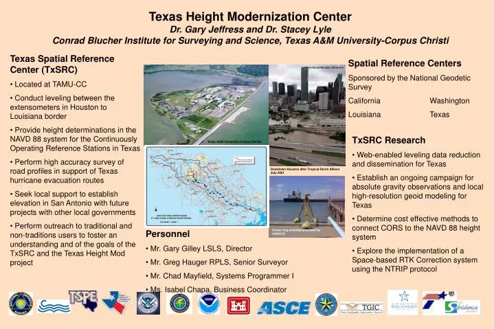
Texas Height Modernization Center Dr. Gary Jeffress and Dr. Stacey Lyle Conrad Blucher Institute for Surveying and Science, Texas A&M University-Corpus Christi. Texas Spatial Reference Center (TxSRC) Located at TAMU-CC Conduct leveling between the extensometers in Houston to Louisiana border

E N D
Texas Height Modernization CenterDr. Gary Jeffress and Dr. Stacey LyleConrad Blucher Institute for Surveying and Science, Texas A&M University-Corpus Christi • Texas Spatial Reference Center (TxSRC) • Located at TAMU-CC • Conduct leveling between the extensometers in Houston to Louisiana border • Provide height determinations in the NAVD 88 system for the Continuously Operating Reference Stations in Texas • Perform high accuracy survey of road profiles in support of Texas hurricane evacuation routes • Seek local support to establish elevation in San Antonio with future projects with other local governments • Perform outreach to traditional and non-traditions users to foster an understanding and of the goals of the TxSRC and the Texas Height Mod project Spatial Reference Centers Sponsored by the National Geodetic Survey California Washington Louisiana Texas Dave Einsel/Houston Chronicle • TxSRC Research • Web-enabled leveling data reduction and dissemination for Texas • Establish an ongoing campaign for absolute gravity observations and local high-resolution geoid modeling for Texas • Determine cost effective methods to connect CORS to the NAVD 88 height system • Explore the implementation of a Space-based RTK Correction system using the NTRIP protocol Texas A&M University-Corpus Christi Downtown Houston after Tropical Storm Allison July 2001 • Personnel • Mr. Gary Gilley LSLS, Director • Mr. Greg Hauger RPLS, Senior Surveyor • Mr. Chad Mayfield, Systems Programmer I • Ms. Isabel Chapa, Business Coordinator Choke ring antennae provided by UNAVCO