Download
1 / 44
440 likes | 599 Views
An Introduction to Open Source GIS North Dakota GIS Users Conference October 24, 2006. Commercial GIS Providers. ESRI Intergraph Autodesk MapInfo. 2004 software revenue: $1.5 billion (daratech.com). What is Open Source?. Developers freely read, modify, and redistribute source code

E N D
An Introduction to Open Source GIS North Dakota GIS Users Conference October 24, 2006
Commercial GIS Providers • ESRI • Intergraph • Autodesk • MapInfo 2004 software revenue: $1.5 billion (daratech.com)
What is Open Source? • Developers freely read, modify, and redistribute source code • Users freely use and distribute programs • There is no cost to acquire the software and there are no maintenance fees • There may be cost for training and development of customized applications
Why Check Out Open Source GIS? • To become somewhat educated on it • Open Source GIS is exploding in functionality and applications • Create a baseline of current offerings so that their progress can be measured • Identify where these tools could fit into state government
Benefits of Open Source GIS • Provides GIS functionality to people who otherwise couldn't afford the tools • Provides opportunity to customize for local needs • Unlimited copies to desktops & servers • Drives industry standards such as Open Geospatial Consortium (OGC) web services such as WMS, WFS, others.
Who is using Open Source GIS? • Federal agencies • United Nations • Local and state government • State Water Commission • Consulting firms • Many others!
Research Environment • Almost all of the tools reviewed were built from source • The primary testing platform is my home computer: • Dell Inspiron 2650 laptop • 512mb RAM (was 256mb) • 1.6gHz with a good tailwind • Dual boot, Suse 10.1 partition • This presentation was built with OpenOffice
Why do this on Linux? • Many/all of the packages run on Windows and have nice install tools • However... • Several of the OSGIS binaries come pre-packaged with other tools; I wanted to have maximum flexibility • Wanted a robust development environment
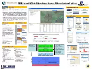
GIS Components Reviewed • Server – Database: • PostgreSQL • PostGIS • pgAdmin • Server – Web: • MapServer • Cartoweb • MapGuide OpenSource • GeoNetwork • Desktop: • OpenJump • QGIS • GRASS • OSSIM
Other Components Used • Geospatial libraries used at the command line and/or by other software: • GDAL – (Geospatial Data Abstraction Library) used for raster processing, e.g., re-projection, build contours, mosaics, conversion between formats. Also used by FME, Google Earth, and ArcGIS 9.2 • OGR – (OpenGIS Simple Features Reference Implementation) is part of GDAL, used for vector processing, e.g., re-projection, conversion between formats
Components To Work on Yet... • GeoServer – used to publish and edit data over the web. Supports OGC formats including WFS-T (transactions) • uDig – User-friendly Desktop Internet GIS is a powerful tool with excellent access to open standard web services • ossimPlanet – richly-featured 3-D globe tool that utilizes multiple local data sources and web services
Components To Work on Yet... • OpenEV – library and application for viewing & analyzing raster & vector data • GeoTools – Java GIS toolkit, supports multiple vector & raster formats, data manipulation, generally used as an API • Mapbender & MapBuilder– web mapping tools that support WMS, WFS, WFS-T, Google, authentication • Web tools such as Chameleon, ka-map
Desktop GIS Desktop GIS Desktop GIS Database(s) File(s) Generalized GIS Architecture Commercial: ArcGIS, ArcExplorer, ArcPad OS: OpenJump, QGIS, uDig, GRASS, OSSIM Web Applications Database Applications Server Applications Commercial: ArcIMS, Metadata Explorer, ArcGIS Server OS: MapServer, GeoNetwork, GeoServer Commercial: ArcSDE, Oracle Spatial OS: PostGIS Commercial: ArcGIS Server, ArcGIS Image Server OS: GeoServer?, PostGIS Shapefiles, Images, CSV Commercial: Oracle, SQL Server OS: PostgreSQL
Ready or Not, Here We Go! • Buckle in and hang on...
Database: PostgreSQL • Enterprise class database • Not just for geospatial use • ArcSDE may run on this in the future • http://www.postgresql.org
Database: PostGIS • Works with PostgreSQL • Spatially enables a database • Similar to ArcSDE or Oracle Spatial, though no raster support • Does geoprocessing, e.g., buffer, intersect, area, etc. • http://postgis.refractions.net
Database: PostGIS – Data Loading • Command line with shp2pgsql • GUI with QGIS plug-in • Other, e.g., applications, WFS-T
Database: pgAdmin • Administration & development tool for PostgreSQL • SQL queries, job scheduling, etc. • http://www.pgadmin.org
Web: MapServer • Dominant “engine” behind open source interactive web mapping & web services • Accesses multiple data types including ArcSDE (except for raster) • Developed at Univ. of Minnesota • http://mapserver.gis.umn.edu
Web: CartoWeb • Interactive mapping presentation and development tool, uses MapServer • Very robust and functional • security • WMS support • PDF printing • http://www.cartoweb.org
Web: MapGuide Open Source • From Autodesk • Appears to have many of the tools and development functionality of commercial products • Support for ArcSDE, OGC WMS • https://mapguide.osgeo.org/
Web - GeoNetwork • Used for metadata editing, loading, publishing, and searching, data viewing • Used by the UN's Food and Agriculture Organization • Appears to meet/exceed commercial offerings • http://geonetwork-opensource.org
Desktop - OpenJump • Has a long history which include forks into other projects • Allows access to ArcSDE • Active development from around the world • http://openjump.org
Local shapefile layer PostGIS layer GIS Hub (with VPN) layers GIS Hub WMS layer
Desktop – QGIS (Quantum GIS) • Bob's current favorite! • Offers limited on-the-fly projection • Plug-ins including those for GPS units • Can provide GUI to GRASS • http://qgis.org
Desktop - GRASS • Geographic Resources Analysis Support System • Developed by US ACOE in 1982-1995, now in academic community • Offers advanced analysis and display • Works with QGIS • http://grass.itc.it
Desktop - OSSIM • Open Source Software Image Map • Pronounced “awesome” and it is! • Remote sensing, image processing • Plugins available, e.g., NASA WorldWind • Future – working with QGIS • http://www.ossim.org
Whew! Are We Done Yet?! • OK, time to bring it home...
Open Source GIS - Pros • Free, no annual maintenance • Worldwide community support, professional support also available • Less dependencies between software • Unlimited copies to servers and desktops • Runs on multiple platforms • Freedom to create a package as needed
Open Source GIS - Cons • Too many choices – a good problem? • Generally lack good cartography, projection on-the-fly, printing, robust editing, and full ArcSDE support • There is some risk of development ceasing for a given tool – stay with the larger tools • Less local training opportunities • Smaller local knowledge / user base
Food for Thought • Open Source GIS tools are already in use by governmental and private organizations around the world • Open Source GIS is a way of getting GIS to organizations and users while greatly reducing cost • Be realistic, evaluate carefully - there is no perfect commercial or Open Source GIS software
A Vision for the Future • Both commercial AND Open Source GIS tools should be on the list of products to be evaluated when deploying GIS • It shouldn't really matter which software is being used or is to be used: Vendor A, Vendor B, or Open Source - data standards are the important item
Want to Learn More? • White paper comparing tools: http://www.refractions.net/white_papers/index.php?file=2006-06-01_oss_briefing.data • General resource to users and developers: http://www.maptools.org • O’Reilly Reference book: Web Mapping Illustrated, by Tyler Mitchell • Open Source Geospatial Foundation: https://www.osgeo.org • Definition of open source and other info: www.opensource.org
Thank You! Bob Nutsch GIS Coordinator State of North Dakota 701-328-3212 bnutsch@nd.gov