Download
1 / 6
60 likes | 159 Views
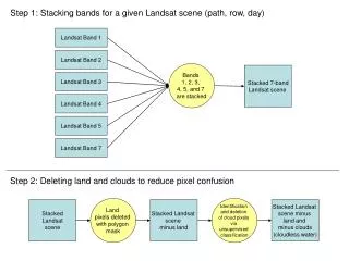
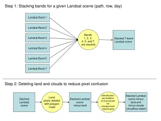
Landsat Discussion. NGAC Meeting March 17-18, 2011. Background. Landsat’s four-decade long continuous global coverage is required to address many multidisciplinary policy and operational issues for which high resolution imagery is not a substitute.

E N D
Landsat Discussion NGAC Meeting March 17-18, 2011
Background • Landsat’s four-decade long continuous global coverage is required to address many multidisciplinary policy and operational issues for which high resolution imagery is not a substitute. • NGAC has previously endorsed the Imagery For The Nation program, which addresses high resolution requirements.
NGAC Recommendation • The NGAC strongly supports the establishment of the National Land Imaging Program as described in the Administration’s FY 2012 budget proposal and we encourage the Department of the Interior to implement the program as soon as possible. • The NGAC looks forward to providing advice to the Department on the development and implementation of the program. • This recommendation is made in the context of a more comprehensive multi-agency, multi-resolution, multi-sensor imagery program for the nation. Approved by the NGAC – March 18, 2011
Dependent on Landsat Imagery • Global price of corn, wheat, soybeans, and rice • Wildfire risk assessment and response throughout the US • Water management in the western states • Coastal zone management nationwide • Monitoring of deforestation worldwide • Monitoring of global warming • Crop and forest pest monitoring
The Value of Landsat • “Landsat is a national asset, and its data have made – continue to make – important contributions to U.S. economic, environmental, and national security interests” (Bush Administration, 2004) • “Because Landsat enables us to see Earth’s surface so clearly, so broadly, so objectively, we gain invaluable insights about the complexity of Earth systems and the condition of our natural resources.”(Obama Administration, 2011) • The discontinuation of Landsat data is estimated to cost the nation $935.8 million per year. (OSTP, 2007)
Operational Uses Of Landsat • Support of DoD operations • Agricultural production monitoring • Wildland fire risk assessment • Coastal change analysis • Emergency response • Recreation planning • Ecosystem mapping • Mineral exploration • Water resource planning • Water rights monitoring administration • Land use and land cover change • Snow and ice monitoring • Pest detecting and monitoring • Deforestation monitoring • Wildlife habitat management • Wetlands rehabilitation • Weather prediction • Range management • Irrigation management • Invasive species monitoring • Carbon cycle monitoring • Mapping groundwater discharge zones • Inventory of toxic releases • Soil analysis • Forest management • Volcanic activity