Download
1 / 20
200 likes | 231 Views
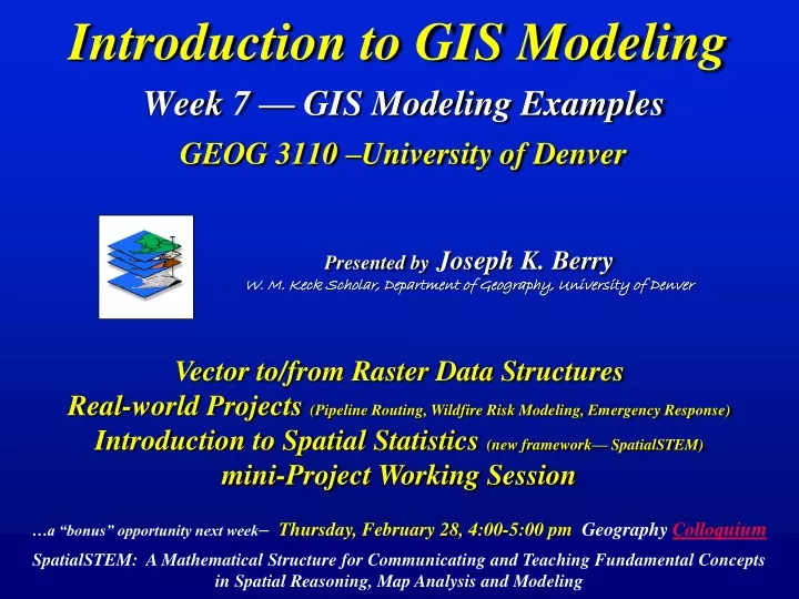
Presented by Joseph K. Berry W. M. Keck Scholar, Department of Geography, University of Denver. Introduction to GIS Modeling Week 7 — GIS Modeling Examples GEOG 3110 –University of Denver. Vector to/from Raster Data Structures

E N D
Presented byJoseph K. Berry W. M. Keck Scholar, Department of Geography, University of Denver Introduction to GIS ModelingWeek 7 — GIS Modeling ExamplesGEOG 3110 –University of Denver Vector to/from Raster Data Structures Real-world Projects (Pipeline Routing, Wildfire Risk Modeling, Emergency Response) Introduction to Spatial Statistics (new framework— SpatialSTEM) mini-Project Working Session …a “bonus” opportunity next week– Thursday, February 28, 4:00-5:00 pm Geography Colloquium SpatialSTEM: A Mathematical Structure for Communicating and Teaching Fundamental Concepts in Spatial Reasoning, Map Analysis and Modeling
V to R– burning the points, lines and areas into the grid (fat, thin and split) R to V– connecting grid centroids, sides and edges (line smoothing) Vector to/from Raster (direct calculation) (Berry)
V to R– uses a point file of cell centroids and converts polygon features that intersect Implied Grid with Centroids Centroid Point File Vector Map (polygons) … the corresponding grid cells are assigned the value of the “point in polygon intersection” Polygons with Overlaid Points Raster Map Vector to Raster (centroid implied) …as the points fall Note: this technique is very sensitive to cell size (features smaller than cells) and complexity of boundary shape …but it is really fast (Berry)
Exporting MapCalc Data Layers ESRI GridASCII Format just for fun (you are having fun, right?)— Export the MapCalc Tutor25.rgs Elevation map layer in both ESRI GridASCIIformat and Surfer ASCIIformat …browse to an appropriate folder and Save exported file To Import grid a map— Map Analysis button Import select File Type browse to file press OK. Note: the analysis grid specifications for the file must be the same as the MapCalc database… see Optional Exercise #10 for a tutorial on Export/Import Surfer ASCII Format (Berry)
Geo-registration and Configuration (“header” first 6 records) Data Structures/Formats (partially self-documenting Flat File) Matrix Originis upper-left (Esri Grid ASCII file) Legend and Display information not included Valuesfrom left to right 2094 Geo-registration and Configuration [ ] 500 1st Row Origin (Col 1, Row 1) …end 1st Row 2094 …end …25 numbers read from left to right define the first row …end …end …end (LL corner) Blocks of 25 numbers contain the Values defining each row of the analysis frame from top to bottom (25 values/row) …end …end …end …end …end …end …repeat for all rows— 25C x 25R = 625 total grid cells …end …end #COLUMNS #ROWS LONGITUDE (LL corner) LATITUDE (LL corner) CELL SIZE (in decimal degrees) NO DATA value (null) …end …end Map Values(bottom portion) (Berry)
Data Structures/Formats (partially self-documenting Table) Configuration Valuesfrom left to right Legend and Display information not included #COL #ROW CELL SIZE (MapCalc CSV file imported into Excel) Lower- left is Matrix Origin (Col 1, Row 1) 1800 (LL corner) Geo-registration Lat Lon Col Row Lat/Lon of grid cell centroid is stored for each grid cell location Map Values Each line (record) in the table is a grid cell location — each column (field) is a separate map variable Strings of 25 numbers contain the Values defining each row of the analysis framefrom bottom to top end 1st Row …each Record characterizes a Grid Cell location for all Map Variables …repeat for all rows— 25C x 25R = 625 total grid cells (Berry)
Legend and Display Formats (fully self-documenting Table) Data Type — Display Type — Display Mode Geo-registration and Configuration (Top portion) Lattice or Grid 2D or 3D Continuous or Discrete (MapCalc RGS table) Lattice Display Type 3D Display Mode LON LAT #COL #ROW CELLSIZE #MAPS (LL corner) (Feet) Continuous Surface Data Type Map Name Units, Map Type, Derivation Command 19 Map Layers Max_Value = 2500 Min_Value = -500 Range = 2000/10 = 200 contour interval Auto-generated Labels …etc. Map Values(Embedded Table) Each column (field) is a Map Layer Elevation, Water… Elevation Map 19 Maps Grid Display Type Water Map 800 2D Display Mode Discrete Surface Data Type Title Font Title Font Legend Font Legend Font …strings of 25 numbers in a field contains all of the Values for an entire row of the analysis frame User-specified Labels 0= Dry Land 1= Spring 2= Stream 3= Pond 4= Lake 5= Lake Shore 6= Fork 7= Inlet 8= Outlet Start 1st Row (LL corner) end 1st Row 1800 (Berry)
Class Logistics and Schedule Midterm Study Questions (hopefully you are participating in a study group) Midterm Exam…you will download and take the 2-hour exam online (honor system) sometime between 8:00 am Friday February 15 and must be completed by 5:00 pm Wednesday February 19 …whew!!! Exercise #6 (mini-project) — you will form your own teams (1 to 4 members) and tackle one of the eight projects; we will discuss the project “opportunities” in great detail later in class …assigned tonight Thursday, February 11 and final report due Monday, February 25 by 5:00pm Submit via two emails, one with report Body attached and the other with Appendix attached No Exercise this Week 7— a moment for “a dance of celebration” Exercises #8 and #9— you can tailor to your interests by choosing to not complete either or both of these standard exercises; in lieu of an exercise, however, you must submit a short paper (4-8 pages) on a GIS modeling topic of your own choosing. I need to know your choices by next Wednesday as I will form new teams for exercises #8 and #9. …you need to submit a one-paragraph description of your topic the Wednesday before class Optional Exercise Week 10— exchanging grid data (Import/Export) Grad Student Special Report …PowerPoint presentation or Short Paper on a Topic of your choice (Berry)
BP Pipeline Routing (Global Model, 2003) Fort Collins FC 4% Corridor SD 1% Corridor Optimal Path San Diego The simulation is queued for processing then displayed as the Optimal Route (blue line) and 1% and 4% Optimal Corridors (cross-hatched) (digital slide show BP_Pipeline_routing) A Web-based Application for Identifying and Evaluating Alternative Pipeline Routes and Corridors, paper for GITA Oil and Gas Conference (Berry)
Modeling Wildfire Risk(Impacts Model, 2008) Increased population growth into the wildland/urban interface raises the threat of disaster… (digital slide show Wildfire Risk Modeling) …a practical method is needed to identify areas most likely to be impacted by wildfire so effective pre-treatment, suppression and recovery plans can be developed A Mapping Firewall: Modeling and Visualizations Assess Wildfire Threats, Risks and Economic Exposure, feature article for GeoWorld (Berry)
Backcountry Emergency Response(Rappelling, 2010) (digital slide show Emergency Response) Topic 29 – Spatial Modeling in Natural Resources (Berry)
More Enriching Projects/Applications …but— (digital slide show TerrainFeatures ) (digital slide show ForestAccess) Topic 11 – Characterizing Micro Terrain Features Topic 29 – Spatial Modeling in Natural Resources …deleted Spatial Analysis “enrichment” slide sets—recent classes have “voted” to skip the formal presentation… (Optional on your own) (Berry)
Spatial Analysis Traditional GIS Store Travel-Time (Surface) Forest Inventory Map • Cells, Surfaces • Continuous Geographic Space • Contextual Spatial Relationships • Points, Lines, Polygons • Discrete Spatial Objects • Mapping and Geo-query Spatial Statistics Traditional Statistics Spatial Distribution (Surface) Minimum= 5.4 ppm Maximum= 103.0 ppm Mean= 22.4 ppm StDev= 15.5 • Mean, StDev (Normal Curve) • Central Tendency • Typical Response (scalar) • Map of Variance (gradient) • Spatial Distribution • Numerical Spatial Relationships Map Analysis Evolution(Revolution) …past six weeks …later (Berry)
Spatial Analysis Operations (SpatialSTEM Framework) Traditional math/stat procedures can be extended into geographic space to stimulate those with diverse non-GIS backgrounds and interests to… “think analytically with maps” Math Math Stat Spatial Analysisextends the basic set of discrete map features (points, lines and polygons) to map surfaces that represent continuous geographic space as a set of contiguous grid cells, and thereby provides a Mathematical Framework for analyzing and modeling the Contextual Spatial Relationships …within and among grid map layers Mathematical Perspective: …what information is generated by the processing (Berry) — Reclassify, Overlay, Distance, Neighbors …how the data values are obtained for processing (Tomlin) — Local, Focal, Zonal, Global Basic GridMath & Map Algebra ( + - * / ) Advanced GridMath (Math, Trig, Logical Functions) Map Calculus (Spatial Derivative, Spatial Integral) Map Geometry (Euclidian Proximity, Narrowness, Effective Proximity) Plane Geometry Connectivity (Optimal Path, Optimal Path Density) Solid Geometry Connectivity (Viewshed, Visual Exposure) Unique Map Analytics (Contiguity, Size/Shape/Integrity, Masking, Profile) Map Analysis Toolbox Unique spatial operations Alternative Frameworks for Spatial Analysis Operations: (Berry)
Spatial Analysis Operations (Math Examples) Advanced Grid Math — Math, Trig, Logical Functions MapSurface Spatial Derivative 2500’ Map Calculus — Spatial Derivative, Spatial Integral …is equivalent to the slope of the tangent plane at a location 500’ The derivative is the instantaneous “rate of change” of a function and is equivalent to the slope of the tangent line at a point Surface Fitted Plane Curve SLOPE MapSurfaceFitted FOR MapSurface_slope Slope draped over MapSurface Spatial Integral Dzxy Elevation 65% …summarizes the values on a surface for specified map areas (Total= volume under the surface) ʃ Districts_Average Elevation 0% Advanced Grid Math COMPOSITE Districts WITH MapSurface Average FOR MapSurface_Davg Surface Area …increases with increasing inclination as a Trig function of the cosine of the slope angle MapSurface_Davg SArea= Fn(Slope) cellsize / cos(DzxyElevation) Surface The integral calculates the area under the curve for any section of a function. Curve (Berry)
Spatial Analysis Traditional GIS Store Travel-Time (Surface) Forest Inventory Map • Cells, Surfaces • Continuous Geographic Space • Contextual Spatial Relationships • Points, Lines, Polygons • Discrete Objects • Mapping and Geo-query Spatial Statistics Traditional Statistics …next 2 weeks Spatial Distribution (Surface) Minimum= 5.4 ppm Maximum= 103.0 ppm Mean= 22.4 ppm StDev= 15.5 • Mean, StDev (Normal Curve) • Central Tendency • Typical Response (scalar) • Map of Variance (gradient) • Spatial Distribution • Numerical Spatial Relationships Map Analysis Evolution(Revolution) (Berry)
Spatial Statistics Operations (SpatialSTEM Framework) Traditional math/stat procedures can be extended into geographic space to stimulate those with diverse non-GIS backgrounds and interests to… “think analytically with maps” Stat Math Stat Spatial Statisticsextends the basic set of discrete map features (points, lines and polygons) to map surfaces that represent continuous geographic space as a set of contiguous grid cells, and thereby provides a Statistical Framework for analyzing and modeling the Numerical Spatial Relationships …within and among grid map layers …what information is generated by the processing (Berry) — Surface Modeling, Spatial Data Mining …how the data values are obtained for processing (Tomlin) — Local, Focal, Zonal, Global Basic Descriptive Statistics (Min, Max, Median, Mean, StDev, etc.) Basic Classification (Reclassify, Contouring, Normalization) Map Comparison (Joint Coincidence, Statistical Tests) Unique Map Statistics (Roving Window and Regional Summaries) Surface Modeling (Density Analysis, Spatial Interpolation) Advanced Classification (Map Similarity, Maximum Likelihood, Clustering) Predictive Statistics (Map Correlation/Regression, Data Mining Engines) Map Analysis Toolbox Statistical Perspective: Unique spatial operations Alternative Frameworks for Spatial Analysis Operations: (Berry)
Spatial Statistics Operations (Stat Examples) Continuous Map Surface Discrete Point Map Keystone concept is… “Spatial Autocorrelation” Geographic Distribution Inverse Distance Weighted (IDW) spatial interpolation assigned distance-weighted average of sample points Standard Normal Curve Average = 22.9 StDev = 18.7 Data Space Surface Modeling techniques are used to derive a continuous map surface from discrete point data– fits a Surface to the data. …lots of NE locations exceed +1Stdev X= 22.9 Geographic Space In Data Space, a standard normal curve can be fitted to the histogram of the map surface data to identify the “typical value” (Average)– fits a Curve. + 1StDev (41.6) 22.9 • 1StDev • (4.2) In Geographic Space, this typical value forms a horizontal plane implying the average is everywhere. Numeric Distribution …click anywhere on the histogram and all map locations in that range are highlighted …click anywhere on the map surface and the corresponding histogram pillar is highlighted (Berry)
Is Technology Ahead of Science? “Maps as Data” • Is the "scientific method" relevant in the • data-rich age of knowledge engineering? • Is the "random thing" pertinent in deriving • mapped data? • Are geographic distributions a natural extension • of numerical distributions? • Can spatial dependencies be modeled? • How can commercial“on-site studies" • augment traditional research? (Berry)
…mini-Projects Working Session Who is doing what? Cam and Nick are working on the Landslide Susceptibility Project James, Gustavo and Sarah are working on the Transmission Line Routing Project Darin is working on the Pipeline Spill Project …tell us about some of your trials, tribulations and successes so far …then it is “free time” to work on your mini-Projects due Tuesday by 5:00pm (Berry)

![Data Modeling [Comparison of data modeling techniques ]](https://cdn0.slideserve.com/205866/data-modeling-comparison-of-data-modeling-techniques-dt.jpg)