Download
1 / 11
110 likes | 262 Views
Oracle Spatial Concepts. Concepts. G eometric data types Oracle Spatial data model S patial L ayer s S patial query model S patial indexing « W indow » queries and «join» queries. Types of Spatial Data. GIS (mapping) data. CAD data. CAM data. Geometric Types. Points (X1, Y1, [Z1])

E N D
Concepts • Geometric data types • Oracle Spatial data model • SpatialLayers • Spatial query model • Spatial indexing • «Window» queries and «join» queries
Types of Spatial Data GIS (mapping) data CAD data CAM data
Geometric Types • Points (X1, Y1, [Z1]) • Line Strings (X1, Y1, [Z1], ...Xn, Yn, [Zn]) • self-crossing lines are supported • lines that close to form a ring have no implied interior • straight, curved or mixed (compound) shapes
Geometric Types (cont.) • Polygons (X1, Y1, [Z1], ... Xn, Yn, [Zn]) • polygons are rotation independent; outer rings must be counter clockwise, inner rings (voids) must be clockwise. • coordinates must close and interior is implied • interior area can be voided using additional elements (polygon with hole) • self-crossing polygons are not supported • straight, curved or mixed (compound) shapes
Self-crossingline strings Point Line string Valid Self-crossingpolygons Polygon with hole Polygon Not valid Geometric Types Compound line string Arc line string Optimized polygons Compound polygon
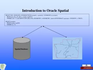
Geometric Representations • Spatial attribute of a spatial feature: geometric representation of its shape in some coordinate space • Called geometry • Oracle Spatial Object-Relational model represents geometries using tables with a single column of type MDSYS.SDO_GEOMETRY and a single row per geometry instance • Relational model: table with a predefined set of columns of type NUMBER and one or more rows for each geometry instance
Spatial Data Model Spatial layer Geometries Elements Point Line Polygon
Elements • Basic building block of a geometry • Element types • Point • Line • Polygon • Constructed using coordinates • Limit on number of coordinates Element 6 Element 5 Element 4 Element 2 Element 7 Element 1 Element 3 Hawaii, USA
Geometry 1 California Geometry 2 Texas Geometry 3 Florida Geometry 4 Hawaii Geometry • Represents a spatial feature • Consists of an ordered set of primitive elements
Layers • Consist of geometries that share a common set of attributes • A layer is a geometry column in a table States layer