Download
1 / 27
270 likes | 420 Views
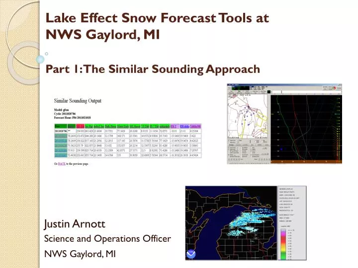
Lake Effect Snow Forecast Tools at NWS Gaylord, MI Part 1: The Similar Sounding Approach . Justin Arnott Science and Operations Officer NWS Gaylord, MI. Introduction. “Legacy Approach” Threat Maps Flowcharts 12 km NAM Pattern Recognition BUFKIT

E N D
Lake Effect Snow Forecast Tools at NWS Gaylord, MIPart 1: The Similar Sounding Approach Justin Arnott Science and Operations Officer NWS Gaylord, MI
Introduction • “Legacy Approach” • Threat Maps • Flowcharts • 12 km NAM • Pattern Recognition • BUFKIT • Demand for improved spatial/temporal evolution in the NDFD • Can we improve upon these tools? • LE Similar Sounding approach (this talk) • High Resolution Local WRF (Part II)
The BGM Approach (Evans and Murphy 2008) • Archive BUFKIT sounding graphics for lake effect events • One “representative sounding” per event. • Derive LES-important parameters from these soundings • Create database • Compare current forecasts to database to find the most “similar soundings” • Retrieve radar imagery/summary of similar events
The APX Approach • Archive RUC BUFR soundings every hour for the winter season • Derive sounding-based parameters • Similar to those at BGM with some exceptions • ML Wind Direction/Speed • Inversion Height/Delta T • 850 T/Delta T • Moist Depth • Mean Tdd (Below 900, 850-700, 700-500) • DGZ Depth • Bulk Shear
The APX Approach - Continued • Create CWA-mean values • Use apx,kpln,anj,lm1,ktvc,kcad,kciu BUFR sites • Create database of RUC-Based Parameters • “Match” current forecast soundings with database to find similar events • Scoring a blend of objectivity/subjectivity • Three ‘tiers’ of scoring
The APX Approach - Continued • Provide 1 hour loop of radar from matching events • Use NCDC Level 3 archive • More information than snapshot?
The APX Approach – To Date • Period of Archive • 2010NOV26 - 2011FEB22 • 57 days with lake effect • 1127 ‘sounding hours’ • Removed hours with significant synoptic precipitation
The Result Run Information Quarter Weight Full Weight Half Weight
Caveats • RUC 00hr Sounding = Truth? • RUC is non-hydrostatic with relatively few vertical levels – but runs every hour! • Will be replaced with Rapid Refresh once it becomes operational • Many parameters not yet taken into account • Time of Day/Time of Year • Persistence • A plethora of meteorological-parameters
Let’s Turn This Approach Around • Have netCDF Level 3 base reflectivity • Can we look for sounding parameters that correlate to different reflectivity patterns? • E.G. What parameters bring high reflectivities far inland? • What parameters bring heavy snow to Gaylord? Alpena, Traverse City, etc.
Site Specific “LES Roses” • Data: • Hourly average point reflectivity data • For this presentation use KGLR/KTVC • Hourly Mixed Layer Mean Wind direction
KGLR • 280-300 degree maximum • Confirms conceptual models
KTVC • 320-340 degree maximum
Other Investigations? • Variable scatterplots
Summary • APX Similar Sounding Approach • Similar to BGM, yet different! • Hourly RUC Soundings • Average of numerous CWA BUFR points • Now operational to forecasters • Over 1000 soundings in one cool season • Should improve given more data
Summary – continued • Using Archived LES Radar data • “LES Roses” • Variable/Reflectivity scatterplots • New forecaster training tool • How does LES behave in the APX CWA. • When does TVC get hit? GLR?
Future Plans • New Sounding-based variables • Surface to inversion base mean Tdd, Directional shear, etc. • Move away from average approach • Have a score for EACH sounding site, then make a composite score. • Reassess weights for creating “matches” • Add COOP data in addition to radar • Current approach limited for eastern U.P. • Move from 2D to 3D approach? • E.G. Like a LES-tuned CIPS?
Future Plans - Continued • Develop reflectivity-based LES climatology • Create LES Roses for multiple sites • Deeper investigations of parameter/reflectivity correlations • Use to adjust similar sounding matching techinque • Move away from just point-based • Banded vs. cellular • Inland extent • Expand Training Tool Potential • Intro to LES • Debunk LES Myths
Acknowledgements • NCDC • For radar data and Weather and Climate Toolkit export capability • APX Forecasters • For testing tool