Download
1 / 7
80 likes | 192 Views
Demonstration Using the GIS Inventory for Environmental Professionals John Jediny Deputy Associate Director for NEPA Oversight Council on Environmental Quality Executive Office of the President John_H_Jediny@ceq.eop.gov. What is a NEPA review and how does GIS help?

E N D
DemonstrationUsing the GIS Inventory for Environmental ProfessionalsJohn JedinyDeputy Associate Director for NEPA Oversight Council on Environmental Quality Executive Office of the PresidentJohn_H_Jediny@ceq.eop.gov
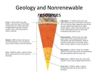
What is a NEPA review and how does GIS help? • A NEPA review is the process of determining how specific activities under a Proposed Action will impact particular Resources Areas within the Human Environment. • The collective review of these components aids in determining the issues and concerns that need to be addressed, and identifies the presence and level of “significant” impacts of a given federal action. Impacts on NEPA Review Context & “Extraordinary Circumstances” Public Controversy Timing and Situational Awareness. Other Permitting and Review Requirements Unique or Novel Project Elements Unique or Unknown Risks Scientific Controversy on Impacts Resource Areas Land Use Cultural, Historic, Tribal Resources Geology and Soils Biological Resources Ecological Resources Utilities and Infrastructure Waste Water Quality Human Health and Safety Socioeconomic Environmental Justice Air Quality Others… • Activities • Siting • Engineering • Construction • Operation • Decommissioning • Reasonably Foreseeable Actions Human Environment *Where GIS can assist… *The NEPA review is NOT the NEPA analysis or document, it is the process of determining the appropriate level of NEPA analysis (i.e. CE, EA, EIS)
What is the GIS Inventory for Environmental Professionals? There are 3 components to this effort… Data Tools Functionality Document: “GIS Inventory for Environmental Professionals” Document: “Free GIS Applications” Document: “Applying GIS in the NEPA Process”
So what did we do? and how is this different than the maps we currently have … What we did… What we do today…
So now you have all the data in one location… and now you can ALSO Add your own notes and organize the map to suit your need View the map in 2D and 3D Add additional content and functionality Make a Presentation
What will this presentation cover? GIS Inventory for Environmental Professionals • Explain why we inventoried Web Services (dynamic) not Shapefiles (static) • How to navigate and use the GIS Inventory Demo of “ArcGIS Explorer” one of the Free GIS Applications • Adding layers from the GIS Inventory • Adding content in ArcExplorer • ArcGIS Explorer – Basemaps, Presentation Mode, 3D mode & Add-in Functionality
Web Services (dynamic) vs. Shapefiles (static) Why not Shapefiles? Shapefiles and other GIS data that requires you to download as a file have three issues: 1. They are large- requiring large amounts of storage and processing speed from your computer. This drastically reduces the performance and speed of working with GIS. 2. They are static- the information they contain is only as current as when they were published and/or uploaded. 3. They are not interactive- When using a “Web Services” you can often click on a specific feature on the map to have it return detailed information about that feature. Often this is the most useful functionality, as it provides detailed information about the layer and may contain links to other databases relevant to the feature. Data files do not offer this functionality. Providing GIS data through their “Web Services” drastically improves the speed, quality, and functionality of using GIS. As all of the storage and processing of the GIS data occurs on the GIS server at the agencies not on your computer.