Download
1 / 26
260 likes | 268 Views
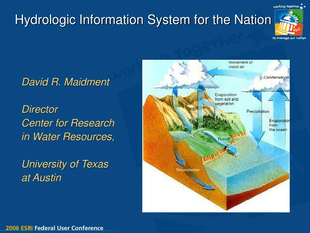
Hydrologic Information System for the Nation. David R. Maidment Director Center for Research in Water Resources, University of Texas at Austin. Supported by the National Science Foundation Develops cyberinfrastructure and services for hydrologic science in US universities

E N D
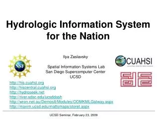
Hydrologic Information System for the Nation David R. Maidment Director Center for Research in Water Resources, University of Texas at Austin
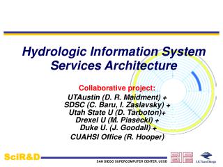
Supported by the National Science Foundation Develops cyberinfrastructure and servicesfor hydrologic science in US universities Legally independent organization based in Washington DC Consortium of Universities for the Advancement of Hydrologic Science, Inc (CUAHSI) CUAHSI HydroView Components Hydrologic Synthesis Hydrologic Observatories Hydrologic Information Systems Measurement Technology
CUAHSI HIS Partner Institutions Project Collaborator CUAHSI Member CUAHSI has 110 member universities
HIS Goals • Hydrologic Data Access System – better access to a large volume of high quality hydrologic data • Support for Observatories – synthesizing hydrologic data for a region • Advancement of Hydrologic Science – data modeling and advanced analysis • Hydrologic Education – better data in the classroom, basin-focused teaching
Most used applicationsare Excel ArcGIS Matlab Then come programming languages Fortran C/C++ Visual Basic CUAHSI Member Survey Results Which of the four HIS goals is most important to you? Data Access Science Observatories Education
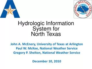
CUAHSI Hydrologic Information System A multiscale web portal system for water data and models North American and Global 1:1,000,000 scale 1:500,000 scale United States 1:100,000 scale River Basin 1:24,000 scale Watershed 1:1200 scale River reach Point scale A home
Water Data Water quantity and quality Soil water Rainfall & Snow Modeling Meteorology Remote sensing
NWISWeb site output # agency_cd Agency Code # site_no USGS station number # dv_dt date of daily mean streamflow # dv_va daily mean streamflow value, in cubic-feet per-second # dv_cd daily mean streamflow value qualification code # # Sites in this file include: # USGS 02087500 NEUSE RIVER NEAR CLAYTON, NC # agency_cd site_no dv_dt dv_va dv_cd USGS 02087500 2003-09-01 1190 USGS 02087500 2003-09-02 649 USGS 02087500 2003-09-03 525 USGS 02087500 2003-09-04 486 USGS 02087500 2003-09-05 733 USGS 02087500 2003-09-06 585 USGS 02087500 2003-09-07 485 USGS 02087500 2003-09-08 463 USGS 02087500 2003-09-09 673 USGS 02087500 2003-09-10 517 USGS 02087500 2003-09-11 454 Time series of streamflow at a gaging station
CUAHSI Hydrologic Data Access System http://river.sdsc.edu/HDAS NCDC NASA EPA NWS USGS Observatory Data A common data window for accessing, viewing and downloading hydrologic information
Observation Stations Observation Stations Map for the US Ameriflux Towers (NASA & DOE) NOAA Automated Surface Observing System USGS National Water Information System NOAA Climate Reference Network
NWIS Station Observation Metadata Describe what has been measured at this station
Data Sources NAWQA Storet Ameriflux LTER NCDC Extract NCAR NWIS Transform CUAHSI Web Services Excel Visual Basic ArcGIS C/C++ Load Matlab Fortran Access SAS Applications Some operational services
Web Page Scraping http://nwis.waterdata.usgs.gov/nwis/discharge?site_no=02087500&agency_cd=USGS&.... Programmatically construct a URL string as produced by manual use of the web page Parse the resulting ASCII file
CUAHSI Web Services Web Application: Data Portal • Your application • Excel, ArcGIS, Matlab • Fortran, C/C++, Visual Basic • Hydrologic model • ……………. • Your operating system • Windows, Unix, Linux, Mac Internet Simple Object Access Protocol Web Services Library
Transfer of Research Results • Friday Oct 28: I announced the NWIS web services in a CUAHSI cyberseminar • Wednesday Nov 2: Jason Love, from a private firm, RESPEC, in Sioux Falls, South Dakota, posted on the EPABasins list server:“Occasionally one comes across something that is worth sharing; the CUAHSI Hydrologic Information Systems - Web Services Library for NWIS is a valuable tool for those of us interested in rapidly acquiring and processing data from the USGS, e.g., calibrating models and performing watershed assessments.” • He provided a tutorial on how to use the services with Matlab Technology transfer from academia to private sector to public sector took less than 1 week!
Series and Fields Features Series– ordered sequence of numbers Point, line, area, volume Discrete space representation Time series – indexed by time Frequency series – indexed by frequency Surfaces Fields– multidimensional arrays Continuous space representation Scalar fields – single value at each location Vector fields – magnitude and direction Random fields – probability distribution
North American Regional Reanalysis of Climate Evaporation Precipitation Variation during the day, July 2003 NetCDF format mm / 3 hours
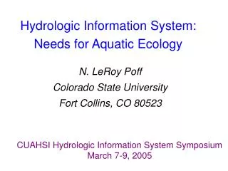
Digital Watershed How can hydrologists integrate observed and modeled data from various sources into a single description of the environment?
Digital Watershed Hydrologic Observation Series Geospatial Data Digital Watershed Remote Sensing Fields Weather andClimate Fields A digital watershed is an overlay of observation series and fields on a geospatial framework to form a connected database for a hydrologic region
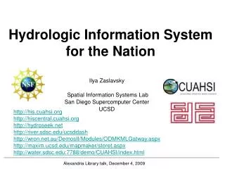
CUAHSI Hydrologic Information System Hydrologic Information System Hydrologic Observing System Hydrologic Modeling System
Watershed Hydrovolumes Hydrovolume Geovolume is the portion of a hydrovolume that contains solid earth materials USGS Gaging stations
Water Balance Model Vertical water fluxes of evaporation, precipitation, and groundwater, and inflow and outflow in streams, change water storage in watershed Evaporation Precipitation Storage Streamflow Streamflow “How much water do we have? “ George W. Bush during 1996 Texas drought Groundwater recharge
Water Balancing Model Fields Series Geospatial
Federal State Local Academic Water OneStop • Like Geospatial OneStop, we need a “Water OneStop” – a common window for water data and models • Advancement of water science is critically dependent on integration of water information