Download
1 / 17
180 likes | 612 Views
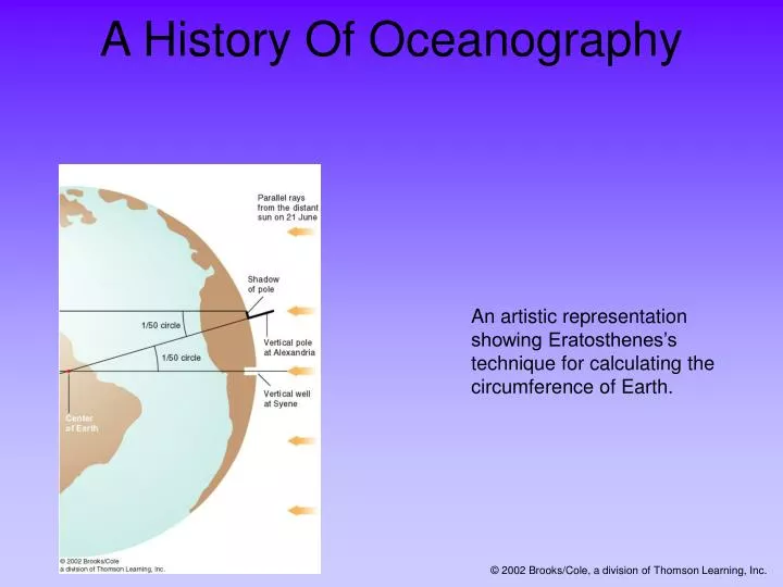
A History Of Oceanography. An artistic representation showing Eratosthenes’s technique for calculating the circumference of Earth. © 2002 Brooks/Cole, a division of Thomson Learning, Inc. Look For The Following Key Ideas In Chapter 2.

E N D
A History Of Oceanography An artistic representation showing Eratosthenes’s technique for calculating the circumference of Earth. © 2002 Brooks/Cole, a division of Thomson Learning, Inc.
Look For The Following Key Ideas In Chapter 2 * The origins of marine science lie in voyaging. Technological advances have led to modern oceanography. * Earth’s shape and circumference were accurately measured around 230B.C. at the Library at Alexandria. * The H.M.S. Challenger expedition was the first purely scientific voyage of oceanic exploration. * Modern marine science research is usually conducted by teams of specialists working for oceanographic or military institutions. * The tools of modern oceanography include satellites, piloted and remotely controlled vehicles, and computer modeling. © 2002 Brooks/Cole, a division of Thomson Learning, Inc.
Voyaging Begins Voyaging on water was important to many early civilizations. The Egyptians, Cretans and Phoenicians were all skilled sailors. Cartographers, or chart makers, recorded information about locations, landmarks and currents. Today, charts are detailed graphic representations of water and water-related information. © 2002 Brooks/Cole, a division of Thomson Learning, Inc.
Science For Voyaging The Library at Alexandria, in Egypt, was founded in the third century B.C. This library stored information on every area of human endeavor. Eratosthenes of Cyrene was the second librarian at Alexandria. He was the first to calculate the circumference of Earth. He also invented a system of longitude and latitude. The principles of celestial navigation were invented at the Library at Alexandria. © 2002 Brooks/Cole, a division of Thomson Learning, Inc.
Science For Voyaging A third century B.C. chart showing the system of latitude and longitude developed by Eratosthenes. Diagrams showing the calculation of lines of latitude and longitude. © 2002 Brooks/Cole, a division of Thomson Learning, Inc.
Voyages Of The Oceanian Peoples The Polynesian colonizations are an example of knowledge of oceans and marine science used to colonize a vast number of islands. “Red Arrows” indicate the direction and order of settlement. © 2002 Brooks/Cole, a division of Thomson Learning, Inc.
Vikings The Vikings, Scandinavian adventurers, used fast and stable ships to explore (and pillage) places as far away as Kiev, Constantinople, Iceland, Greenland, and Newfoundland. © 2002 Brooks/Cole, a division of Thomson Learning, Inc.
Chinese Contributions • Chinese navigators set out in the 1400s to explore the Indian Ocean, Indonesia, Africa and the Atlantic. Their ships were laden with gifts designed to show China’s wealth and degree of civilization. The Chinese invented: • The central rudder • Water-tight compartments • Sails on multiple masts © 2002 Brooks/Cole, a division of Thomson Learning, Inc.
The Age Of Discovery Europeans explored the world by sea during the Renaissance. Henry the Navigator - Explorers under his patronage compiled detailed charts and explored the west coast of Africa. Christopher Columbus - Although he never saw the mainland of North America, his stories inspired other explorers to follow. Ferdinand Magellan –Although Magellan died en route, the small surviving portion of his crew circumnavigated the globe. © 2002 Brooks/Cole, a division of Thomson Learning, Inc.
The journey of the Magellan expedition, the first voyage around the world. © 2002 Brooks/Cole, a division of Thomson Learning, Inc.
Voyaging For Science James Cook , a commander in the British Royal Navy, is credited with leading voyages that greatly contributed to scientific oceanography. Some of the accomplishments of James Cook and his scientists include: Verification of calculations of planetary orbits Charting of New Zealand and the Great Barrier Reef, Tonga and Easter Islands Initiation of friendly relations with many native populations Sampling marine life, land plants and animals Recording data concerning the ocean floor and geological formations © 2002 Brooks/Cole, a division of Thomson Learning, Inc.
Voyaging For Science The routes of Cook’s three voyages exploring the Pacific. © 2002 Brooks/Cole, a division of Thomson Learning, Inc.
The First Scientific Expeditions The British Challenger expedition of 1872-1876 was the first oceanic expedition dedicated to scientific research. The United States Exploring Expedition launched in 1838 was a naval and scientific expedition. The HMS Beagle, on which Charles Darwin served as a naturalist, voyaged to South America and some Pacific Islands. © 2002 Brooks/Cole, a division of Thomson Learning, Inc.
The First Scientific Expeditions HMS Challenger ’s track, from 1872-1876. © 2002 Brooks/Cole, a division of Thomson Learning, Inc.
Voyages For Science In The Twentieth Century What advances in oceanic exploration occurred in the twentieth century? Polar Exploration- explorers reached both the North and South poles in the twentieth century The Meteor Expedition- the first expedition to use modern optical and electronic equipment for oceanographic investigation The Atlantis –investigations by scientists on this research vessel confirmed the presence of the Mid-Atlantic Ridge. The Trieste – a blimp-like bathyscaphe which descended into the Challenger Deep area of the Mariana Trench Glomar Challenger –samples obtained by scientists on this drilling ship provided confirming evidence for seafloor spreading and plate tectonics. © 2002 Brooks/Cole, a division of Thomson Learning, Inc.
The Rise Of Oceanographic Expeditions Three of the most prominent oceanographic institutions in the United States: Woods Hole Oceanographic Institution Scripps Institution of Oceanography Lamont-Doherty Earth Observatory of Columbia University © 2002 Brooks/Cole, a division of Thomson Learning, Inc.
Summary Marine science has been practiced for thousands of years. New technology, and research institutes, such as the Woods Hole Oceanographic Institute, allow scientists to continue to build on the discoveries of earlier scientists. © 2002 Brooks/Cole, a division of Thomson Learning, Inc.