Download
1 / 8
80 likes | 84 Views
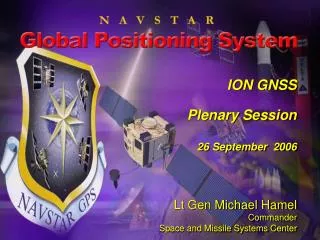
Lt Gen Michael Hamel Commander Space and Missile Systems Center. ION GNSS Plenary Session 26 September 2006. QZSS constellation. QZSS constellation. 80. 60. 40. 20. 0. -20. -40. -60. -80. 60. 80. 100. 120. 140. 160. GPS Enterprise. International Cooperation Japan – QZSS

E N D
Lt Gen Michael Hamel Commander Space and Missile Systems Center ION GNSSPlenary Session 26 September 2006
QZSS constellation QZSS constellation 80 60 40 20 0 -20 -40 -60 -80 60 80 100 120 140 160 GPS Enterprise • International Cooperation • Japan – QZSS • Russia - GLONASS • Europe and other countries • Department of Defense • Services (Army, Navy, AF, Marines) • Agencies (NGA, DISA, etc.) • Civil Applications • Search and rescue • Surveying and mapping • Trucking and shipping • Aviation • Offshore drilling • Fishing and boating • Department of Transportation • U.S. Coast Guard • Federal Aviation Administration (FAA)
GPS Evolution Space Segment • Modernized(Block IIR-M) • 2nd civil signal (L2C) • M-Code signals (L1M, L2M) • Flex A/J power (+7dB) • Modernized(Block IIF) • 3rd civil signal (L5) GPS III(Block III) • Increased accuracy • Increased A/J power(up to 20 dB) • Signal integrity • Search and Rescue • Common signals with Galileo (L1C) • Legacy(Block IIA/IIR) • Basic GPS • C/A civil signal (L1C/A) • Std Pos. Service • Precise Pos. Service • L1 & L2 P(Y) nav • NDS Control Segment Legacy • TT&C • L1 & L2 monitoring Upgraded(AEP) • IIR-M IIF TT&C • WAGE, AII, LADO • SAASM • New MCS/AMCS Modernized(OCX V1) • New Architecture • Signal Monitoring GPS III(OCX V2) • GPS III TT&C • NAVWAR, GNOC • L1C, L2C, L5 • Flex Power • Real-Time C2 User Segment Legacy • Man Pack • MAGR, PLGR • RCVR-3A, 3S • OH, UH • FRPA, CRPA Upgraded • DAGR • CSEL Modernized • MUE • MSR • GAS-1 • MAGR2K • GB-GRAM
Recent Accomplishments • Launched a new era of GPS services • First GPS IIR-M (14) launched 25 Sep 05, operational on 16 Dec 05 • New military signal (M-Code) and new civil signal (L2C) • GPS IIR-M (15) launched 25 Sep 06 • Fielded operational improvements • Legacy Accuracy Improvement Initiative--improves accuracy 10-50% • Provide “zero age of data” to warfighters • Continue to mature GPS Ops Center (GPSOC) capabilities • New acquisition strategies for next generation GPS • GPS III satellites – block development approach • OCX Operational Control Segment – incremental design -development • MUE/MSR – Modernized User Equipment/Modernized Space Receiver contracts underway/in work • Established new USG interagency GPS governance processes – National PNT EXCOM (NPEC) and Coordinating Office (NPCO)
GPS IIR-15(M) • Launched Monday, 25 September 2006 • 1450 Eastern time • Cape Canaveral, FL • Second Modernized Block IIR satellite • Will broadcast PRN Code 31 • Anticipate setting healthy mid-October
Accuracy Current Requirement Current Objective Continuous Performance Improvement • Key Measures of Effectiveness help evaluate GPS services • Accuracy • Bounded inaccuracy • Assured Availability • Integrity • Resistance to RF Interference/Jamming
GPS Program Responsibilities • Sustaining capabilities for military and civil users worldwide • Maintain ground systems/on-orbit satellites, launch new satellites – partnership across AF Space Command • Fielding GPS enhancements, such as L-AII • Modernizing constellation with new signals and capabilities • Second IIR-M launch Sep 06, first IIF launch 2008, first III launch 2013 • New civil and military GPS signals • Transitioning control segment from legacy to new Ops Control Segment (OCS) in Spring ‘07 • Continuing work with Galileo and international community • Developing next generation of GPS • Acquisition strategies for space, ground, and user segments • Synchronizing space, control, and user equipment upgrades • ManagingGPS systems & supporting stakeholders • Technical baselines, interfaces, performance • Supporting/participating in key fora – NPEC/NPCO, DSB, IRT, ION