Download
1 / 19
190 likes | 320 Views
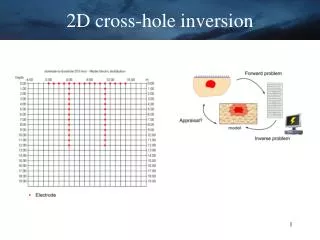
2D cross-hole inversion. Sinkhole collapses detection. Source: Deceuster, Delgranche, Kaufmann, Faculté Polytechnique de Mons. Sinkhole collapses detection. Source: Deceuster, Delgranche, Kaufmann, Faculté Polytechnique de Mons. Mining application.

E N D
Sinkhole collapses detection Source: Deceuster, Delgranche, Kaufmann, Faculté Polytechnique de Mons
Sinkhole collapses detection Source: Deceuster, Delgranche, Kaufmann, Faculté Polytechnique de Mons
Mining application Cross-hole survey for iron prospection in Heiba (China) Source J. Zhe, University of Adelaide
Brine tracer injection (10 days after) Injection: 300 l in 2 days (brine resistivity 0.05 ohm.m) Courtesy of Hyunday Institute of Construction Technology, Korea
3D fluide migration monitoring Source: Doug La Brecque
3. Survey strategies and interpretation How well-resolved are the models? A simple test…
DOI index approach Homogeneous reference models: qA= average app. resistivity * 5 qB= average app. resistivity / 5
DOI Index Approach Using the DOI index: electrical imaging in marine environment, Denmark Source: Marescot, L. and Loke, M.H, SAGEEP 2004, Colorado Springs
DOI index approach Using the DOI index: electrical imaging in marine environment, Denmark Source: Marescot, L. and Loke, M.H, SAGEEP 2004, Colorado Springs
Summary example:Looking for paleo-valleys Source: Marescot et al., 2003, Eclogae Geol. 96
Resistivity Mapping Apparent resistivity map
P6 P5 2D resistivity tomography
Advantages • Resistivity surveys are simple and robust • Non expensive • Allows for a rapid qualitative mapping of the underground • Can be used for a 2D or 3D investigation of the subsurface • Resistivity contrasts are often present in geological deposits
Drawbacks and needs for further developments • Sensitive to non-unicity in the modeling solutions • Quantitative aspects still need to be developed but significant progresses are currently made (3D inversion) • Sensitivity to noise and metallic bodies such as pipes (urban area) • Usually need for a galvanic coupling • Progress needed for better defining the resistivity properties of geological material (petrophysics) • Method mainly sensitive to the fluid in rocks. Good for hydrology but a problem in archeology and soil investigations: the signature of a feature can dramatically change with the seasons or weather conditions!