Download
1 / 86
900 likes | 1.14k Views
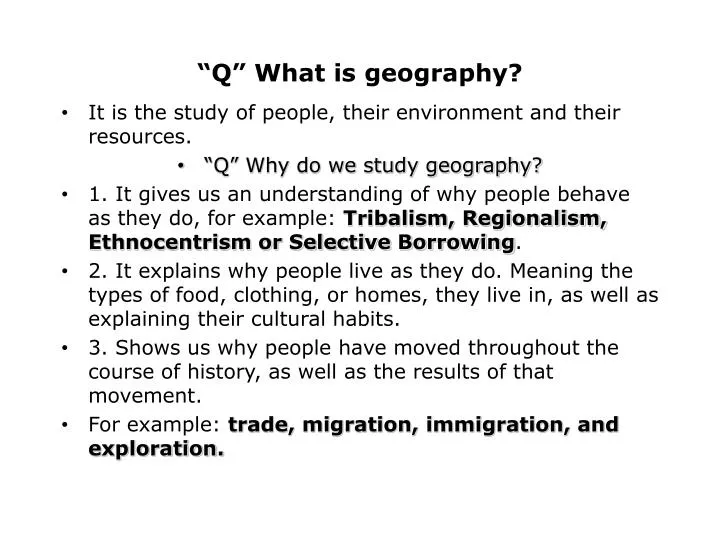
“Q” What is geography?. It is the study of people, their environment and their resources. “Q” Why do we study geography? 1. It gives us an understanding of why people behave as they do, for example: Tribalism, Regionalism, Ethnocentrism or Selective Borrowing .

E N D
“Q” What is geography? • It is the study of people, their environment and their resources. • “Q” Why do we study geography? • 1. It gives us an understanding of why people behave as they do, for example: Tribalism, Regionalism, Ethnocentrism or Selective Borrowing. • 2. It explains why people live as they do. Meaning the types of food, clothing, or homes, they live in, as well as explaining their cultural habits. • 3. Shows us why people have moved throughout the course of history, as well as the results of that movement. • For example: trade, migration, immigration, and exploration.
Geography is described through 5 themes. • 1.Location 2.Place 3.Interaction 4.Movement 5.Region • 1. Location helps us to identify a place. The two ways we determine location are Absolute (latitude and longitude), and Relative (a comparison to some place else). • 2. Places are described by their Physical and or Human characteristics. • 3. Interaction between people and the environment occurs all the time. Sometimes we adapt to our environment, other times we modify it to better suit our needs.
4. Movement occurs for several reasons, to find food, a better life, freedom, or as a result of trade. • Sometimes movement is forced upon people, for example the slave trade. • 5. Regions are defined as an area with its own unique characteristics. • They can be defined by physical, cultural, political, or economic qualities.
“Q” What is Topography? • It is the physical or natural features of a place. Topography can impact the political, economic, or social development of a place.
“Q” What are topographical features that can affect the development of places? • 1. Mountains 4. Rivers • 2. Plains 5. Peninsulas • 3. Plateaus 6. Islands • The last major feature that can have profound effects on places is climate, this can be the most severe of all because it is the one feature man cannot control.
“Q” What is Climate? • It is the average weather (temperature and precipitation) a place has over a period of time (a minimum of 50 years). • “Q” What are the factors that affect climate? • A. Latitude - distance north or south from the equator. • B. Nearness to the oceans. • C. Elevation above sea level.
Topic: Geography Africa Major Features • 1 - Climate: There are several different climate zones found within Africa • a. Mediterranean: warm summers and cool winters excellent for agricultural development. Only 3-5 % of Africa • b. Tropical Rainy: Central Africa, Rain Forest region Only 10-12% of the continent is tropical. • c. Savanna (Sahel): Borders the desert, rain is seasonal. • This part of Africa can experience periods of long drought. Ethiopia and Somalia are examples, this is apx. 40% of Africa. • d. Arid (Desert) 40% of Africa gets less than 10" of rain per year. This is not enough to support life. Major Deserts include the Sahara, Kalahari, Namib, and the Nubian.
2. Africa contains several major rivers, the Nile, Niger, Zaire, and the Zambezi. The Nile is the longest river in the world. Most of Africa’s civilizations developed along either the Nile or the Niger River.
3. Elevation: Mountains and Plateaus dominate the continent of Africa. It is the highest continent in the world. It makes it difficult for trade and travel.
4. Resources: • a. Agricultural: many of the cash crops grown in Latin America can also be found in the Central and South Western portions of the continent. The North coast is rich in olives, cotton, grapes and other fruits. • b. Mineral: The Sahara and the mountains of the south are rich in mineral deposits. Resources like gold, diamonds, oil, and platinum, to name a few are the future of the continent. • 5. Regular Coastline: Most of the African coastline is smooth, which prevents Africa from having easy access to trade. The lack of harbors has impacted the accessibility of the continent, referred to as the "Dark Continent".
Major Problems and Solutions • 1. Tribalism is one of the greatest problems in Africa. Tribalism occurs as a result of the Topography and, the difficulty for the people to come into contact with one another. • The biggest results of Tribalism have been the civil wars fought over the course of time, and the inability to resist Imperialism due to the lack of unity. • 2. Desertification: The climate is one of the greatest concerns of Africa. The savanna is subject to frequent droughts; this is causing more land each year to turn to desert. • One of the solutions is restricting the overgrazing of the Sahel and planting trees to act as wind barriers. In addition, farmers are experimenting with new seeds and fertilizers to try new crops.
3. Developing Nations (Third World): There are 53 nations in Africa, they are all third world. They are all overpopulated, lack skilled labor, lack capital, and are faced with serious health problems. • The solutions are difficult to implement for many reasons, Tribalism, government corruption, poverty and lack of foreign interest. • Africa has created several organizations to combat these problems; • The OAU (Organization of African Unity), and the ANC (African National Congress) both of these are attempting to promote Pan-Africanism and the hope is that Africans willbegin to act in the interests of all not just in their own self interests.
4. Urbanization: Although it is helping to alleviate the Tribal and Ethnic problems, other problems are arising. Overcrowding and poor living conditions for the lower classes are contributing to the outbreaks of many diseases.
Middle East Geography • 1. Location and Lack of Natural Barriers: • Impacts: a. Access to the products from Asia (India-China). • b. Tremendous economic growth before an all water route was discovered. • c. Advanced technology and civilization. • d. Cultural diversity. • e. Easy to invade.
2. Rivers: The Nile, Tigris, and Euphrates • Impacts: a. Good agricultural development. • b. Easy access to trade. • c. Population distribution near the rivers • 3. Climate: Arid, 75% of the Middle East receives less than 10" of rain a year. • Impacts: a. Overpopulated • b. Fertile land is densely populated.
Impacts of Mountains: • a. They prevent moisture-bearing clouds from reaching the interior. • b. Mineral resources. • 5. Natural Resources: • Agricultural - cotton, wheat, olives, and tobacco. • Mineral: 70% of the worlds known oil reserves are located in this region. • Impacts: • a. Resources provide adequate trade for the Middle East. • b. Victims of Imperialism.
6. Topography: 90% of the Middle East is desert, Sahara and Arabian. • Problems and Solutions • 1. Scarcity of Water: Saudi Arabia and many of the other Middle Eastern countries have used their wealth to build Desalinization Plants. These plants allow them to take water from the sea and process it into fresh water.
2. Imperialism: Due to the resources found in the Middle East they have had problems of Imperialism. They have used two weapons to attain their freedom, • (Islamic Fundamentalism and O.P.E.C.). • O.P.E.C. allows the Middle Eastern countries to use oil as a political weapon. They can use the flow of oil as a tool to achieve their goals. • Islamic Fundamentalism has been used to limit the effects of westernization in the Arab world. It has also been responsible for the revival of Theocracy in the Arab world.
4. Arab-Israeli Relations: Since the formation of Israel in 1948, there have been several wars fought between Israel and her Arab neighbors. • In addition to the wars there have also been countless acts of terrorism that have taken many lives. • Several peace treaties have been signed, yet they have failed to achieve any lasting peace.
The Camp David Accords:in 1979 a treaty was signed between Egypt and Israel. For the first time since 1948 Israel was officially recognized by an Arab State. • Results of The Camp David Accords • A. The Sinai Peninsula was returned to Egypt. • B. Menachem Begin (Prime Minister of Israel) and Anwar el Sadat (President of Egypt) were awarded the Nobel Peace Prize for their efforts to end the hostilities in the Middle East. • C. Egypt was expelled from the Muslim League. • D. In 1981 Sadat was assassinated by Islamic Fundamentalists
The Oslo Accords: In 1993 Yasir Arafat and Yitzhak Rabinsigned a peace treaty, which at that time was hoped to be the end of hostilities between Palestinians and Israeli's. • As a result of this treaty the PLO and Israel recognized each other for the first time in history. • Results of the Oslo Accords • A. Palestinians living in the occupied territories of the Gaza Strip and the Town of Jericho were granted self-rule. • B. Terrorism was denounced as a weapon by both sides • C. Yitzhak Rabin was assassinated in 1996 by an extreme nationalist who felt that he had betrayed Israel.
Geography/China • Major Geographic Features: • 1. Surrounded by a variety of natural barriers that has allowed China to be isolated over most of their history. • a.The Gobi Desert to the north (cold and dry) • b.The Himalayans to the south west • c.The Tibetan Plateau to the west • d. Rainforests to the south
2. Rivers: • a.Huang (Yellow River); the start of China’s first civilizations. Called the yellow river due to the silt carried downstream • b.Chang (Yangtze River); the busiest river for trade. Present site of the Three Gorges Dam project to control the flooding. • The Grand Canal: Although man made it is one of the most important waterways for trade and irrigation. It links the Yellow and Yangtze rivers.
3. Resources: • a.Agricultural – Tea, rice, cotton, wheat • b. Mineral – coal, iron ore, uranium • 4. Climate: • The climate varies very much in China, the southern parts are impacted by Monsoons and fairly warm, while the northern parts of China are temperate with cold winters.
Impacts of Geography • The Chinese learned how to survive on their own due to the barriers that made travel and trade difficult, as a result an ethnocentric attitude developed. The Chinese called their society the Middle Kingdom. • Major Problems and Solutions • 1. Overpopulation: only the eastern most part of China has arable land for farming, only 20%. As a result they have had to learn how to make the most of the land. Terrace farming was invented during the Ming dynasty. They also developed a variety of Rice that grew faster and as a result could harvest two crops in a single growing season.
Under the leadership of Deng Xiaoping China introduced the One Child Policy to help with the problem. It seems to be working; China’s population is one of the slowest rising populations in the world.
2. Lack of fertile land: only 20% of China is arable (good for farming) as a result it is difficult to grow enough food to feed the population of over 1 billion people. • To help fix this problem Deng Xiaoping introduced the Four Modernizations, this began China’s transformation to an Industrial society. • China is today one of the largest producers of consumer goods, look at the labels of what you buy.
Geography India / South Asia • 1. Mountains: Himalayas, Hindu Kush, and the Eastern and Western Ghats • Impacts: a. Formed barriers separating South Asia from the rest of Asia. • b. Provides three rivers that don’t depend upon the monsoons. • c. Good mineral resources. • 2. Rivers: Ganges, Indus, and Bramaputra • Impacts: a. Irrigation for farming • b. Important routes for trade • c. Cultural diffusion • d. Floods