Download
1 / 22
220 likes | 366 Views
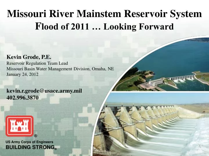
Missouri River Mainstem Reservoir System F lood of 2011 … Looking Forward. Missouri River Mainstem Reservoir System. The Flood of 2011. Missouri River Mainstem System Storage Zones and Allocations 19 January 2012. Storage In MAF. 2011 Peak. 72.8. 73.1. 72.1.

E N D
Missouri River Mainstem Reservoir System Flood of 2011 … Looking Forward
Missouri River Mainstem Reservoir System The Flood of 2011
Missouri River Mainstem System Storage Zones and Allocations 19 January 2012 Storage In MAF 2011 Peak 72.8 73.1 72.1 Exclusive Flood Control 6% Previous Historic max - 1975 68.4 16.3 MAF Annual Flood Control & Multiple Use 16% 56.8 Current=56.5 MAF Carryover Multiple Use 53% Historic min - 2007 33.9 17.9 Permanent Pool 25% 0
Missouri River Runoff above Sioux City 2011 Actual versus Normal Million Acre-Feet March-July runoff of 48.7 MAF exceeded the flood control storage design by more than 20% (40.0 MAF, March-July 1881)
How much is 61.2 MAF? Flow vs. Volume 1 cubic foot per second (cfs) for 1 day = 1.9835 acre-feet [(60 * 60 * 24) / 43,560 = 1.9835] 61,189,000 acre-feet* over 1 year (365 days) equals an average daily flow of 84,500 cfs 51,482,000 acre-feet** over 1 year (365 days) equals an average daily release of 71,100 cfs * Missouri River at Sioux City, IA (includes James and Big Sioux River basins) ** Missouri River at Gavins Point Dam
Significant System Operations in 2011 • Two Projects in Surcharge (Fort Peck and Garrison) • Historic Releases Made at All Mainstem Projects • First Time Spillways Used at Garrison and Big Bend • Many Levees Overtopped/Breached Downstream
Review of 2011 • Self-Assessment, AAR • Independent External Review of WM • Flexible … Aggressive … Communication • 61.2 MAF ~ 1 in 500 year event • Technical Analysis on Flood Control Storage • Understanding Roles / Responsibilities
Independent External Review of WM • Panel members from NRCS, USGS, NWS and Colorado State University • “The panel found no evidence that Corps personnel were attempting to do anything other than to operate the system using the best available methods and to minimize the overall negative consequences. The flood in 2011 was a record-breaking event with unprecedented levels of runoff that could not be predicted in advance, and the Corps responded well to a difficult test of historic dimensions.” (page 84, Summary and Conclusions) • Panel Recommendations • Support a program of infrastructure enhancement. • Update hydrologic studies to include 2011. • Review of System storage allocations. • Improved cooperation/collaboration with NWS, USGS and NRCS. • Studies to enhance data collection and forecasting (sp: plains snow). • Implement modern interactive, graphics decision support system.
Flexible … Aggressive … Communication “Therefore, it is crucial that water releases prior to March 1, 2012 be well above what would otherwise be the case without the reality of damaged levees. The Corps should do all that it can to maximize the reservoir reserves by March 1 without significantly increasing the chances of flooding or having the river run at a level that seriously impedes the repair of levees and other flood structures.” Source: AOP Comment letter from 10 Senators (Grassley and Harkin, IA; McCaskill and Blunt, MO; Nelson and Johanns, NE; Conrad and Hoeven, ND and Johnson and Thune, SD) • Flexible … • If conditions allow, release additional beyond the 16.3 MAF • December – extended the drawdown from 40 kcfs to 20 kcfs • Winter Gavins Release – 22 kcfs (normal max is 20 kcfs) • Studies indicate about 16.8 MAF of FC storage on March 1
Flexible … Aggressive … Communication If basin conditions indicate runoff in 2012 will be similar to 2011, the Corps will be more aggressive in evacuating water from the reservoirs to create additional storage for runoff. “The panel’s first impression about communications was to note that is seems impossible to satisfy everyone’s expectations to be notified promptly and accurately about every decision and eventuality. Officials along the river in various roles should take part of the responsibility for communications, as they do in other public emergencies.” (page 81, Communications)
Effective Communication Kevin’s definition: As it pertains to USACE MRBWM real-time decision-making, effective communication requires a proper balance of communicating decisions and associated impacts … fully realizing that in real-time, decisions change as conditions (e.g. climate/weather, project/river constraints) change … in a manner that the broadest extent of potentially affected persons are aware of these decisions and impacts and have the opportunity to provide timely and relevant feedback. (source: Grode, Kevin)
Preparing for 2012 Runoff Season • La Niña !! • Basin (Soil) Conditions • Plains Snowpack • Mountain Snowpack • Precipitation and Temperature Outlooks
How Will La Nina Affect Us in 2012? During La Nina episodes, the Pacific Northwest and portions of the Northern Rockies in the Missouri River Basin are expected to receive greater than normal precipitation as mountain snowfall, and generally colder than normal temperaturesin the Northern Plains, usually during the January‐February‐March period. Increased plains snowfall and accumulations are generally expected due to the colder than normal temperatures. La Nina episodes create storm track conditions that move through the Pacific Northwest to the Northern Plains (Missouri River basin). Through mid-January, the storm track in the Missouri River basin has been nearly opposite of a characteristic La Nina, with warmer than normal temperatures in the upper Missouri River basin, and below normal precipitation and snow accumulation. However, recently we’ve begun a more typical La Nina pattern.
Soil Moisture Last Year This Year
Temperature / Precipitation 3-month Outlooks Temperature Precipitation February – March - April
Temperature / Precipitation 3-month Outlooks Temperature Precipitation May – June - July
2012 and Beyond … • Jan 1 Runoff Forecast – 26.5 MAF (107%) • Dam / Levee Repairs • Continuous Monitoring of Basin Conditions • Adjust Regulation Plans as Conditions Change • No Guarantees in Real-Time Regulation • Flexible … Aggressive … Communication
Thank You! www.nwd-mr.usace.army.mil/rcc Kevin Grode, P.E.402.996.3870kevin.r.grode@usace.army.mil