Download
1 / 37
410 likes | 662 Views
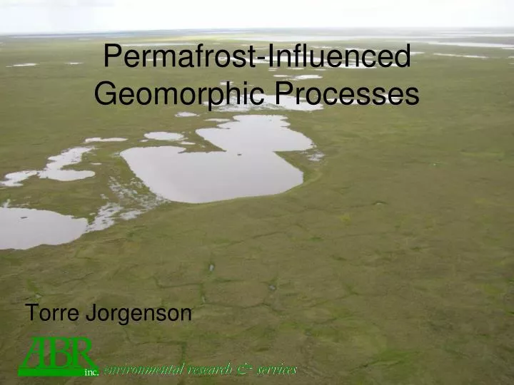
environmental research & services. Permafrost-Influenced Geomorphic Processes. Torre Jorgenson. Overview of Geomorphic Processes. Coasts Storm surges, sedimentation, salinization, permafrost degradation Floodplains Changing flooding, sedimentation, Channel migration

E N D
environmental research & services Permafrost-Influenced Geomorphic Processes Torre Jorgenson
Overview of Geomorphic Processes • Coasts • Storm surges, sedimentation, salinization, permafrost degradation • Floodplains • Changing flooding, sedimentation, • Channel migration • Coastal Plain-Lowlands • Thermokarst lakes, waterbody creation • Lake expansion and shrinkage • Paludification, organic matter accumulation • Ice-wedge Degradation • Uplands • Loss of permafrost aquatard, drainage • Thaw slumps • Thermokarst Lakes in Extremely ice-rich loess (yedoma) • Mountains • Slope Failure
Coastal Ecosystems • Sedimentation (up to 10 cm in big year) • Storm Surges (1970 to 2 m) • Salinization (up to 15 km inland) • Sea Level Rise (3 mm/yr)
Storm Surges October 2002 Storm at Barrow
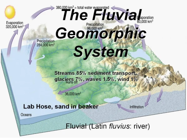
FLUVIAL PROCESSES • Changing flooding, sedimentation, • Channel migration
Upland Sandy Low Scrub Upland Barrens Riverine Barrens Riverine Marsh Riverine Low and Tall Scrub Riverine Wet Meadow Lowland Wet Meadow Riverine Wet Meadows Riverine Lake - Connected Lowland Deep Lake Ecotypes 25-200 yr 1000-2000 years for development 5-25 yr Masssive organics 3-4 yr Layered Organics 1-2 yr Layered fines Rippled sands/fines, with detrital organics Low Water Layered fines w/ clay Massive or Crossbedded Sand GEOMORPHIC PROCESSES ON RIVER FLOODPLAINS Changes over Time: Increasing height, Decreasing flooding frequency, Decreasing sedimentation, Increasing organics, Decreasing thaw depths, Decreasing water depths Decreasing pH Increasing ground ice, Increasing susceptibility to thermokarst,
Decreasing Flooding and Sedimentation River Active-floodplain Cover Deposit Inactive-floodplain Cover Deposit Riverbed/ Riverbars Abandoned- floodplain
Nechelik SCALE IN MILES N 0 1 2 Areas of Erosion and Deposition Area (%) 1.3 Eroded Riverbed/Sandbar 2.6 Riverbed/Sandbar Deposition Channel 7.6 Unchanged Riverbed/Sandbar Channel 1.8 Thaw Basin Drainage/Deposition East 1.0 Other Eroded Terrain River Unchanged Terrain 58.8 Lake-level Change 0.9 Colville Unchanged Water 26.1 Proposed Project In-field Facilities Pipelines Landscape Change from 1955 to 1992, Central Colville River Delta Nuiqsut Erosion and Deposition 8.2% of area changed over 37 yr 2.3% of land eroded At current rate it would take about 1700 years to rework entire delta
Lowland and Lacustrine Ecosystems Lowland Hydrology: 8-11 ka surface Poorly integrated surface Snow-melt recharge Summer Draw-down
Loess Eolian Sand Coastal Plain Geomorphic Model Coastal Plain with Moist/ Dry Tundra Ice-rich Thaw Basin with Wet Tundra Ice-poor Thaw Basin with Wet Tundra Thaw Lake
0.7% of land was eroded over 45-56 year period, 0.01%/yr At this rate it would take 8400 years to rework the surface.
1945 Time Series: Beaufort Coastal Plain Drying location Wetting location
1982 Pond shifts Pond develops
2001 Ponds drains Pond develops Pond drains
Hillslope Geomorphic Processes Water-tracks • Increased drainage, south-facing slopes • Thaw slumps • Thermokarst Lakes in extremely ice-rich loess (yedoma)
Snow Phenology Spring Fall
Thaw Slumps Photo by Andrew Balser
CONCLUSIONS • Regional Factors • Cold climate leading to permafrost development • Coastal Processes (16% of Coastal Plain including Lagoons, 5% land) • Sediment deposition, salinization, thermokarst • Spread of halophytic vegetation, salt-killed tundra • Fluvial Processes (9% of area) • Flooding leading to sediment deposition • Channel migration, erosion, and thaw lakes • Feedback from ice aggradation of flooding regime • Willow thickets, legumes, productive wet sedge
CONCLUSIONS • Lacustrine Processes • (14% areas in lakes, 39% in basins) • Differential sediment deposition • Shoreline Erosion (0.1%/yr) • Lake Drainage (3% of landscape over 100’s yrs) • Carbonate inputs, strong pH gradients • Thermokarst • Ice Wedge Degradation (>3%, up to 20%) • Tussock loss, wet sedge increase, redistribution of water • Hillside Processes • Deeper Drainage, • Gully formation, • Thaw slumps • Deep Thermokarst Lakes