Download

1 / 22
240 likes | 528 Views
Agricultural Survey Bhu Bharati – Nizamabad Pilot Project. Dec 16, 2009 Hyderabad. Speck Profile.

E N D
Agricultural Survey Bhu Bharati – Nizamabad Pilot Project Dec 16, 2009 Hyderabad
Speck Profile • Speck Systems Limited is an over 26 year old ISO 9001:2000 certified company based in Hyderabad, India, offering end-to-end solutions in Cadastral Mapping, Digital Aerial Photogrammetric Mapping, LiDAR Data Acquisition and preparation of 3D maps, Data Conversion, Digital Cartography, Rural and Urban Planning, Vehicle Tracking and GIS applications development. • Speck Systems Limited has well-equipped field survey teams managed by professional land surveyors, capable of undertaking large scale ground control surveys, topographical surveys, AM/FM (automated mapping and facilities management), cadastral and corridor surveys etc.
MR. KCM KUMAR, MANAGING DIRECTOR, SPECK SYSTEMS LTD, RECEIVING AWARD FROM DR. MANMOHAN SINGH, HONORABLE PRIME MINISTER OF INDIA ON BEHALF OF SPECK, FOR THE MOST PROMISING SME OF THE YEAR 2007 Most Promising SME of the Year 2007
Speck Systems Limited being awarded with Indian Geo Spatial Company of the year 2008
Nizamabad District - Profile • Bhu Bharathi was envisaged and adopted by Government of Andhra Pradesh • Approx. 8000 sq.km area of Nizamabad District (AP, India). • This area consists of 922 revenue villages and other habitats within three local revenue divisions.
Some Salient Features • Aerial photography at 1:10,000 scale • UTM projection and Datum WGS 84 • Ground control network using DGPS and ETS for tertiary control points • Ground truthing with hybrid methodology consisting of demarcation on bromide orthoprints and Electronic Total Station surveys for unclear boundaries
No. of Agricultural holdings (in Lakhs) : 9.5 (as against 4.5 estimated in RFP) No. of Acres Surveyed (agricultural land) : 17 Lakhs Major portion of the survey was completed between Jul’07 to Oct’08 during which approx. 4000 acres were being surveyed per day by 100 teams The results of the Agriculture Survey are being validated by Administrative Staff College of India, under Prof. Muralikrishna, who has permitted us to announce that his first cut results are positive and the maximum variation he has found is between 3.5 to 4% We believe that this is the largest re-survey conducted in India within living memory Overview of Agricultural survey completed
Objection Analysis All are minor variations which were rectified and revised LPMs re-distributed to enjoyers
Micropilots and Early Action Plans Between July 2006 and February 2007 a number of experiments were carried out in about 50 villages • Social and Political Acceptability • Accuracy • Validate methodology and process for scaling
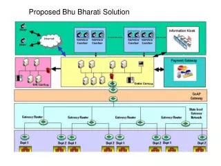
Methodology Adopted • Main principle that data capture and dissemination should be as close to the source as possible • Village Bhu-bharati Centre and Production Centre at District Headquarters • Development of Software Package for field survey that can be used by computer-literate people with minimum amount of training
Methodology adopted for agricultural survey as part of BhuBharati project • Ground Control Point (GCP) Survey • Public Awareness Programs • Cadastral Re-Survey • Generation of Draft LPMs • Distribution of Draft LPMs to enjoyers • Preparation of Cadastral Maps and Land Register • Publication of Land Parcel Map and Administration Process
Ground Control Point Network • The first order points were generated by DGPS system survey based on very high accuracy GPS base stations available in the area, Differential Global Positioning System (DGPS) was used with an accuracy of 1 in 50,000. • The second order control point was at the rate of one point per village. Approximately 1000 second order points are generated by DGPS survey taking the first order points as the base stations. Here GPS of 5mm+1ppm calibrated is used to maintain the accuracy of 1 in 20,000. • The Third order control points of about 500 mts. apart are also carried out using Electronic Total Stations (ETS) of 5mm+5ppm calibrated and the accuracy maintained is 1 in 10,000. These points are required for measuring the cadastral boundaries survey and properties of urban / village sites
Deliverables • Old Village maps digitised • Re-surveyed Village Map • Land Register • Correlation Statement • Summary Statement • GCP sketches
Our Experience • Has to be done in Mission Mode by the Government • Support from District Administration and Line Departments • Mobilisation of enjoyers should be ensured by the deputed staff • Quality of data should be checked and certified by deputed staff at the time of the survey itself • Data has to be put to use immediately within existing institutional framework • Payments should be calibrated with progress of project and not provision of services to citizens
Name: KCM Kumar Mail Id: kckumar@specksystems.co.in