Download
1 / 4
40 likes | 175 Views
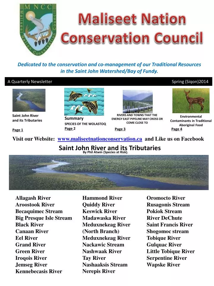
Maliseet Nation Conservation Council. Dedicated to the conservation and co-management of our Traditional Resources in the Saint John Watershed/Bay of Fundy. A Quarterly Newslette r Spring ( Siqon )2014 . Saint John River and its Tributaries

E N D
Maliseet Nation Conservation Council Dedicated to the conservation and co-management of our Traditional Resources in the Saint John Watershed/Bay of Fundy. A Quarterly Newsletter Spring (Siqon)2014 Saint John River and its Tributaries Page 1 Summary SPECIES OF THE WOLASTOQ Page 2 RIVERS AND TOWNS THAT THE ENERGY EAST PIPELINE MAY CROSS OR COME CLOSE TO Environmental Contaminants in Traditional Aboriginal Food Page 4 Page 3 Visit our Website: www.maliseetnationconservation.ca and Like us on Facebook Saint John River and its Tributaries By Phil Atwin(Species at Risk). Allagash River Aroostook River Becaquimec Stream Big Presque Isle Stream Black River Canaan River Eel River Grand River Green River Iroqois River Jemseg River Kennebecasis River Hammond River Quiddy River Keswick River Madawaska River Meduxnekeag River (North Branch) Meduxnekeag River Nackawic Stream Nashwaak River Tay River Nashaaksis Stream Nerepis River Oromocto River Rusagonis Stream Pokiok Stream River DeChute Saint Francis River Shogomoc stream Tobique River Gulquac River Little Tobique River Serpentine River Wapske River
SUMMARY SPECIES OF THE WOLASTOQ By Brian Stuart Natural Resource Technician Page 2
RIVERS AND TOWNS THAT THE ENERGY EAST PIPELINE MAY CROSS OR COME CLOSE TO • By Brian Stuart Natural Resource Technician • With all the newspaper coverage about the tarsands pipeline across the country, I think it’s best to let people in New Brunswick know how it will affect our most important river and towns. • “In New Brunswick, we have a long way to go in coming to terms with the risks as the 400km of new pipeline is proposed to cross 195 waterways, provincially significant wetlands, 3 Natural Protected areas, a number of municipal aquifers and uncededWabanaki territory. There are the unique qualities of the products passing by. Baaken crude is highly volatile and oilsands bitumen sinks. There are the risks to the Bay of Fundy. Tanker traffic creates noise pollution damaging and disruptive to whales, including the endangered north Atlantic right • whale.” Matthew Abbott is the Fundy Baykeeper for the Conservation Council of New Brunswick and Stephanie Merrill is the Director of the Freshwater Protection Program. They can be reached at marine@conservationcouncil. ca and water@conservationcouncil.ca • These are just some of the major rivers and towns (plus all 6 Maliseet Communities) the proposed Energy East pipeline slated to run through • New Brunswick in 2018, may end up either crossing or come in close proximity to. Starting at the provincial boarder between Quebec and New Brunswick, the first town to come in contact with the pipeline is Edmundston, then Grand Falls, Plaster Rock, Stanley, Chipman, Hampton, and Saint John. The first of 11 rivers or streams is the Madawaska River. Next is the Iroquois River, followed by Green River, Quisibis River, Grand River, Little River, Mill Stream, Tobique River, Salmon River above Grand Lake, Canaan River, and the Kennebecasis River before reaching its final destination at Saint John Harbor. Any spill near or at any of these locations will make its way into the main stem of the St. John River and down to the Bay of Fundy. Can we afford to take this roll of the dice? • Quick facts • The crude production needed to fill the Energy East pipeline would generate an additional 30 to 32 million tonnes of carbon emissions each year — the equivalent of adding more than seven million cars to Canada’s roads. • By comparison, filling the proposed Keystone XL pipeline would increase emissions by 22 million tonnes, according to a previous analysis from the Pembina Institute. • Filling the Energy East pipeline would help spur 650,000 to 750,000 barrels per day of additional production from the oil sands. • Despite numerous requests from interveners and members of the public, the NEB’s last major pipeline review did not consider the environmental impacts of producing the crude that would flow in the pipeline. Page 3
Environmental Contaminants in Traditional Aboriginal Food By DrArunaJayawardane MNCChas tested speckled trout and deer samples from Maliseet First Nation communities for environmental contaminants. Seventy five speckled trout samples received from all six Maliseet First Nation communities and nine deer samples (meat) and two liver samples (all from Woodstock) were analysed at Research and Productive Council (RPC) laboratory in Fredericton for contaminants. MNCC received funding for this program from the Regional First Nations Environmental Contaminants Program (RFNEC) of Health Canada. Except the trout samples analyzed from Madawaska, rest contained high level of arsenic, and not safe for consumption in accordance with the People’s Republic of China – PRC export guidelines for finfish. The estimated arsenic content was lowest in the samples from Madawaska (mean=0.095 mg/kg, SD=0.05 mg/kg) and highest in the samples collected from Oromocto (mean=0.73 mg/kg, SD=0.58 mg/kg). On the other hand estimated mercury and cadmium levels for trout samples analysed during the present study were well within safe limit with respect to the PRC export guidelines for finfish. Mercury contamination of the speckled trout samples analysed was almost negligible and minimum and maximum mercury levels were estimated for trout samples from Tobique (mean=0.056 mg/kg, SD=0.007 mg/kg) and St. Mary’s (mean=0.137mg/kg, SD=0.049 mg/kg) respectively. Similarly cadmium content of trout samples was well below the safe limit given in the PRC guidelines for finfish (0.1 mg/kg). Maximum and minimum cadmium contents were reported for samples from Tobique (mean=0.013mg/kg, SD=0.025 mg/kg) and Madawaska (mean=0.0032mg/kg, SD=0.0013 mg/kg) respectively. The deer meat and liver samples collected during the present analysis were tested for the presence of heavy metals arsenic, cadmium, mercury and lead and PCBs. Neither the deer meat nor liver tested contained measurable amounts of PCBs, arsenic or mercury. On the other hand, cadmium and lead contents in deer samples tested were well within safe consumption levels, based on the Health Canada and European Food Safety Authority (EFSA) guidelines. Estimated cadmium content for deer meat and liver were 0.0052 mg/kg (SD=0.0054 mg/kg) and 0.01 mg/kg (SD=0.0063 mg/kg) respectively. Lead content of the deer meat was 0.013 mg/kg (SD=0.0058 mg/kg) and only one liver tested contained measurable amount of lead (0.01 mg/kg). Traditional knowledge study The traditional knowledge project of the current fiscal year was dedicated to prepare a GIS map to present indigenous knowledge of Maliseets about Species at Risk (SAR). This project was funded by the Aboriginal Fund for Species at Risk (AFSAR) and administered through Department of Fisheries and Oceans (DFO). During the present study, MNCC has attempted to present traditional knowledge of Maliseet elders/knowledge holders (gathered during previous studies) about the biology and ecology of Atlantic salmon and American eel. A few elders from Tobique, Kingsclear and St. Mary’s were interviewed to gather necessary knowledge to fill existing information gaps of the data. They provided valuable information on biology, fishery and ecology of salmon and eels in the St. John River. Data collection is over now and map is being prepared at the moment. The GIS map will be ready by the end of March 2014 and as we did in previous years, products and reports generated from this project will be stored in the traditional knowledge data repository at MNCC. The information gathered and presented will be available ethically and culturally appropriate manner for recovery planning and conservation of above wildlife SAR. Page 4