Download

1 / 28
320 likes | 711 Views
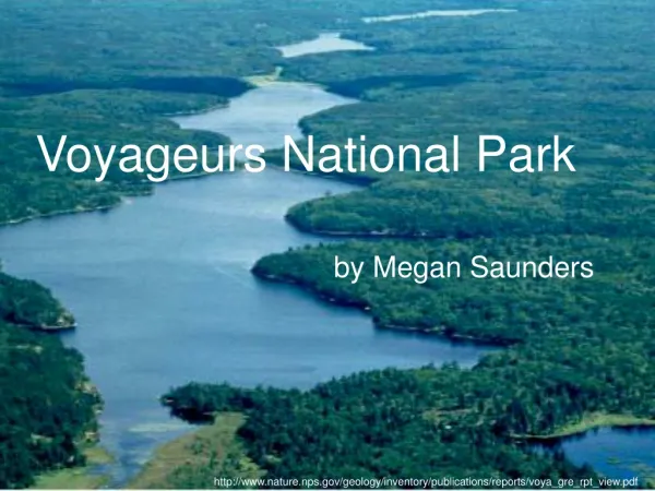
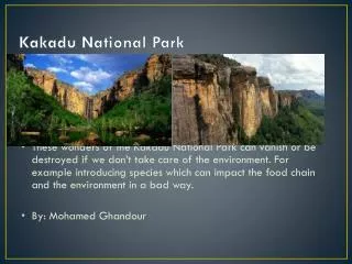
Voyageurs National Park. by Megan Saunders. http://www.nature.nps.gov/geology/inventory/publications/reports/voya_gre_rpt_view.pdf. Interest in protecting the area since 1891. Established as a national park in 1975 Named for historic French-Canadian voyageurs. Voyageurs National Park.

E N D
Voyageurs National Park by Megan Saunders http://www.nature.nps.gov/geology/inventory/publications/reports/voya_gre_rpt_view.pdf
Interest in protecting the area since 1891 Established as a national park in 1975 Named for historic French-Canadian voyageurs Voyageurs National Park
Location of Voyageurs http://nps.seeamerica.org/maps/mn.gif
Voyageurs National Park http://www.us-national-parks.net/images/voya.jpg
Geologic History of Voyageurs • Contains some of the oldest rocks in North America (Archean aged) • Algoman Orogeny • Formed by repeated collisions of isolated areas of crust • Subduction created volcanic island arcs • Later in Orogeny, intrusion of granitic plutons
Geologic History of Voyageurs • In the Proterozoic, isolated crustal regions accreted into one large craton • Voyageurs on Canadian Shield http://www.kettlefallshotel.com/aerilalake.jpg
Geologic History of Voyageurs • Craton covered by inland seas in early Paleozoic • Exposure and erosion during late Paleozoic, Mesozoic, and Cenozoic http://www.destination360.com/north-america/us/minnesota/images/s/voyageurs-national-park.jpg
Geologic History of Voyageurs • Glaciations in Pleistocene • Most recent ended about 10,000 years ago • Glacial scouring • Lake formation • Glacial striations • Polishing • Glacial deposits • Lake formation • Till and moraine deposits http://www.usatravelpal.com/images/states/minnesota/voyageurs-national-park.jpg
Archean Stratigraphic Column of Voyageurs http://www.ux1.eiu.edu/~cfrbj/parks/voya/Voyastarcol4.pdf
Current Geology of Voyageurs • Superior Province • Sub-provinces: • Wabigoon Sub-province • Quetico Sub-province • Wawa Sub-province • Fault Zones: • Rainy Lake-Seine River Fault Zone • Vermillion Fault Zone http://www.nature.nps.gov/geology/inventory/publications/reports/voya_gre_rpt_view.pdf
Current Geology of Voyageurs • Erosional and glacial evidence • Flat landscape • Thin soils • Glacial erratics http://www.nps.gov/voya/index.htm
References American Park Network. http://americanparknetwork.com/voyageurs Geologic Resource Evaluations. http://www2.nature.nps.gov/geology/inventory/gre_publications.cfm Harris, A. G., E. Tuttle, and S. D. Tuttle. 2004. Geology of National Parks (6th edition). Kendall Hunt Publishing Company, Dubuque, IA, 882 p. Kiver, E. P. and D. V. Harris. 1999. Geology of U.S. Parklands (5th edition). John Wiley and Sons, Inc., New York, NY, 902 p. NPS Explore Geology. http://www2.nature.nps.gov/geology/tour/ USGS Geology of National Parks. http://wrgis.wr.usgs.gov/parks
Rocky Mountain National Park Emily VanWyk
Rocky Mountain National Park (ROMO) was established January 26, 1915 with the passing of the Rocky Mountain National Park Act • In 1976 the park was designated a biosphere reserve
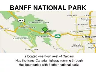
ROMO is located in the North-Central part of Colorado on the Front Range • The Front Range is on the Continental Divide, and is the furthest east part of the Rockies • Called the “roof” of the Rockies, as the some of the highest peaks in the Rockies are found here, including a Handful over 14,000 feet above sea level.
Basement Crystalline RocksPrecambrian The oldest rocks are Precambrian, deposited approximately 1800 million years ago in a marine environment. Shale, sandstone, and carbonates, were interbedded with volcanics. Once lithified, these were metamorphosed into crystalline schists and gneisses which were intruded by massive granitic magma during mountain building. Late Precambrian was a long, intense period of mountain building and regional metamorphism from intrusions
Silver Plume GranitePrecambrian • A huge batholith, 30 miles across, emplaced itself within these gneisses and schists. This is the Silver Plume granite, and outcrops in much of the eastern side of the park. • This granitic batholith contains radioactive materials which allow for precise dating. The formation was intruded 1450 million years before present. • http://www.cliffshade.com/colorado/rmnp/rmnp01.jpg
Creation of Ancestral RockiesThe Paleozoic • Precambrian uplands were eroded, and Paleozoic seas moved over what is now the park. Marine sediments were laid down. • The region uplifted in the Pennsylvanian, creating the Ancestral Rockies. • These were soon leveled by erosion in the Mesozoic when seas transgress.
Laramide OrogenyCretaceous • The Cretaceous marks the last time the sea advanced on the land in the park. • North America plate and Pacific plate collided at the end of the Cretaceous, leading to differential compression, fault blocks, and thrust-faulting.
Creation of the Front Range Tertiary • More uplift, erosion, and volcanism. • Uplifts primarily along old faults, elevation increased. Front Range rises as a series of steps • Movement possibly due to isostatic compensation. • By Quaternary, the Front Range as we know it in height was in place.
The Front Range illustrates thrust faulting and folding, as well as huge, faulted anticline mountains. High angle thrust faults created these features, along with isostatic adjustment. There are major faults on both sides of the range. Extensive activity shows the park is found on the leading edge of the continent. It is hard to understand the formation of the Rockies, as they are located far inland, far from the tectonic boundary. Most geologists think they were created by an extremely low angle subduction, which let crust push under the continental crust all the way inland to push up the mountains. Extensive thrusting built up the huge mountains.
GlaciationPleistocene Early glaciation included two main advances 1.2 million years ago. Most traces of these glacial advances were destroyed by later glacial periods. The oldest evidence can be found on the eastern boundary of the park.
GlaciationPleistocene Bull Lake Glaciation, brutal and long lasting, occurred between 300,000 ybp and 130,000 ybp. This glacial period deepened basins created by earlier glacial periods, and left prominent moraines. These moraines are very close together, indicating a slow retreat speed. They are similar in size, shape, and type of material. Can be found near Shadow Mountain Lake, Beaver Meadows, and Moraine Park.
GlaciationPleistocene • Pinedale Glaciation occurred during Wisconsonian time. This included three episodes which reached their maximum approximately 20,000 to 18,000 years ago. • Sculptured the mountains as we know them, making strong ridges and steep drop offs. This period is responsible for the nearly vertical east face of Longs Peak. • This period was much less intense. • The last Pleistocene Glacier disappeared about 10,000 years ago.
Post Pleistocene Glaciation • Neoglaciation began about 3,800 ybp. • Two major advance/retreat series known. • Currently, there is little more than perennial snowfields and glacierets. These have recently increased in size
Glacial Features • Rock-Basin Lake - Cub Lake, East Inlet • Moraines - Moraine Park • Roche Montonnee - Glacial Knobs • Glacial Pavement - North Inlet • U valleys - Fall River • Cirque • Hanging Valley - Hanging Valley
Sources • usgs.gov/parks