Download
1 / 41
450 likes | 472 Views
Lithosphere and geomorphology. Lithosphere.

E N D
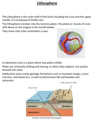
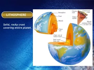
Lithosphere The Earth consist of the crust, the mantle and the core. Lithosphere is created by the Earth’s crust and solid mantle. It lies upon the plastic mantle rock - astenosphere. Lithosphere is studied by geology. It is the science which study the origin, structure, composition and history of the Earth.
Lithosphere-crust: • The crust is the outer layer which is thin and rigid. It floats on the semi-molten rock mantle. It can be divided into two main types continental crust and oceanic crust. • Continental crust (150 – 250 km thick) – granitic crust because it consist of SiAl(silica & aluminum)-, covers the land surface, the base of land mass, it is thicker and lighter than oceanic crust • Oceanic crust – basaltic crust because it consist of SiMg (silica & magnesium), granitic layer missing cover the floor of world’s ocean
In the core of the Earth is radioactive decay from which the convection currents escape towards the surface. They tear the crust apart and dividing it into huge fragments – tectonic plates (crustal plates) – moving away from each other(divergence) or being pushed together (convergence). • Crustal plates are pushed across the Earth’s surface at 50mm/y. • Continental drift – process- continents constantly changed position and size. • Major tectonic plate: Eurasian, North American, South American, African, Pacific, Nazca, IndoAustalian, Antarctic, Phillipine
Crustal plates can converge, diverge or collide.We know 3 main types of plate boundaries according to the direction and movement of the plates. • Diverging(constructive) – forced apart and new crust is created between (e.g. under the ocean – magma reaching the sea floor producing new oceanic crust) - Mid Atlantic Ridge (Europe is moving away from North America) • Converging( destructive) – one plate collides with another, slides under the other (e.g. heavier oceanic plate slides below the lighter continental plate- subduction zone ) – Nazca plate sinks under the South America plate • Slipping – 2 plates move horizontally ”slip” past one other – The Indian plate collide with the Eurasian plate to form the Himalayas • Plate boundaries Rift valleys – East African Rift Valley Mid- oceanic ridges – Mid-Atlantic ridge Fold mountains – Himalayas Horizontal faults – San Andreas in USA
Region where the Earth’ lithosphere forms, are typical for huge seismic and volcanic activity, tectonic movements and endogenic processes which take place within the Earth. • Tectonic movements- mechanical movements of the crust caused by pressure, tension of gravitation, e.g. mountain folding
Tectonic forces (movements) create many crustal failures: faults and folds • faulting usually occurs during an earthquake • Fault - fracture in a rock which involves a movement along one side or both sides. • Shift - total movement • Throw- vertical displacements • Heave- horizontal displacements
Normal fault - result of a tension, strata are pulled apart, one side of it is thrown down - increase of land area (divergence)
Reverse (thrust) fault - result of a compression, one side of the fault plain is thrust over the other (convergence) - overlapping of the strata and the surface area is decreased, e.g. steep slopes are formed of more resistant rocks, gentle slopes are found on softer rocks that are thrown down (by erosion)
Wrench (tear) fault - movement is horizontal but the fracture is vertical, nearby plate boundaries (product of an earthquake)
Landforms produced by faults: • Horst= upland area bounded by low ground either side (fault scarps) a) uplift of a block b) depression of surrounding land e.g.: Harz Mts., Black Forest Extensive horst produce plateau areas (block mountains). Further Earth movements tilt the blocks = tilted blocks = they are divided by faults into subsided (wide deep basins) and elevated sections (mountains). • Rift valley (graben) = reverse of a horst, it´s formed by tension, compression or parallel faults and accompanied by horsts on either side, also can be formed nearby plate boundaries where the plates are pulling apart (e.g. East African Rift Valley).
folding occurs when layers of rock aredistorted but not fractured • Fold - distorted layers of rock • Simple fold - anticline + syncline • Recumbent fold - crumpled several times • Asymmetric fold • Over fold
Earthquakes – seismic activity • - tremors or ground movements caused by shock waves => occur normally at plate boundaries. Plate movement causes stress to build up within the crustal rocks until the rocks break along the line of a fault or cracks in the Earth´s crust. • Actual movement = few cms but the sudden release of seismic (earthquake) energy can be enormous • focus - the point at which the rocks break within the crust. This may be some distance below the surface and the seismic energy emitted from the focus travels in all directions as seismic waves. • epicentre.- the point on the Earth´s surface above the focus • More powerful earthquake is when: · stress was built up for a long time · focus is near the surface
Each year - thousands of earthquakes => few are centred near populated areas and strong enough to cause loss of lives - primary effects (from the violent shaking of the ground during an earthquake), e.g. · buildings may collapse killing people inside them, · shattered window glass may shower on to the streets below · huge cracks may open in the ground · roads may be damaged · water pipes and (electricity) mains may be cut off • Primary effects can generate secondary effects, e.g. · deaths because of food and water shortage · fires _ gas or oil leaking from fractured pipes · diseases _ lack of medical care and clean drinking water · tsunamis _ huge waves caused when earthquake occurs under the sea (1000 kph in open water, 65kph close to land + 15 m high). Created by displacing of the seabed (seafloor) => great damages to coastal areas. • Geomorphological effects = land movements, tsunami, landslides, avalanches.
Volcanoes – volcanic activity • Geothermal heatis released from the Earth´s core at the surface mainly through volcanoes. • Magma pours onto the surface as lava – acid & basic. • Acid lava volcano - mainly steep-sided, common along destructive plate boundaries, Magma - melting of basaltic oceanic crust and marine sediments, (e.g. volcanoes of Phillipines) • Basic lava volcano - common along constructiveplate boundaries, magma - basalt arising directly from the mantle, e.g. Mauna Loa in Hawaii • Geothermal activity Areas with geothermal activity = crust is thin and magma is present at quite shallow depth- magma heats rocks above it (350°C at a depth of less than 5 km). Percolating groundwater is heated and then driven upwards by convection through cracks in the crust. Superheated water begins to boil closer to the surface and then is emitted onto the surface - · fumerole (superheated water turned to steam because of the sudden drop in pressure) · mudpool (bubbling pool of mud – liquefied soil where steam condenses near surface) · hot spring (superheated water + cold groundwater = hot spring at the surface) · geyser (regular eruption of hot water and steam, e.g. geysers in New Zealand)
Endogenic processes • processes within the Earth • Platforms - shields and tables - basic building elements of all the continents - The older the platform, • the smaller the relief! • Mobile orogenic zones- fold (range) mountains from Paleozoic, Mesozoic and Tertiary ages • Land mass Shields - cores of the land mass, e.g. old Scandinavian, Canadian, African, Australian shield created by old igneous (granite) and metamorphic (marble) rocks Tables - parts of platforms where older fold parentn rock was covered by younger (sedimentary) rocks - plains(East-European) Orogenic zones = determined by faults, originated in platform rims or in between them -mountain folding activity • Ocean Oceanic floor - continental shelf, continental slope, abyssal plain, seamounts, mid-oceanic ridges,volcanic islands and trenches Oceanic platforms – the biggest part of ocean’s floor, they are called basins, e.g. Brazil, Argentine – south-west part of Atlantic ocean Oceanic mobile zones - midoceanic ridges, long and narrow mountain ranges, somewhere occurring above the sea level as islands (Pacific Ocean), their length is about 45 000 km e.g. Mid-Atlantic Ridge
Rocks • In the upper part of lithosphere we can find all the chemical elements. There are mostly silicate minerals which are combination of oxide, silicon and some other metals – mica • rocks - composition of minerals or organic remains igneous rocks sedimentary rocks metamorphic rocks • Metamorphic rocks - is formed by pressure and extreme heat applied to existing rocks within the earth’s crust causing them to change their mineral structure and texture. E.g marble, gneiss
Igneous rock-created by crystallization of silicate minerals, water and various gases consist of magma or lava. • According to the presence of SiO2, rocks are divided into: • - acid, e.g. granite, • - neutral, e.g. andesite, • - basic, e.g. basalt,
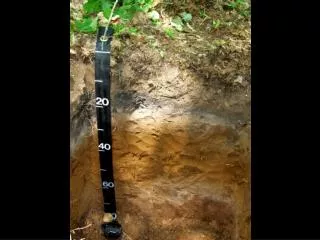
Sedimentary rocks -is formed by deposition of rock particles that have been eroded. Mechanical and chemical disruption of rocks is called weathering. - Mechanical weathering = disintegration of rocks by the influence of different temperatures, frost or organism´s activity. - Chemical weathering = rocks are decomposited by air and water (by chemical processes) and changed into rocks of different nature compared to the previous ones. e.g sandstone, limestone, dolomite
Metamorphic rocks - is formed by pressure and extreme heat applied to existing rocks within the earth’s crust causing them to change their mineral structure and texture. E.g marble, gneiss
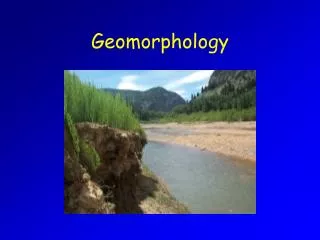
Geomorphology • - is science about the Earth’s relief. It studies the formation, evolution and character of relief and its forms. • -it is a landmark between solid lithosphere + pedosphere and liquid hydrosphere + gaseous atmosphere • Relief (Georelief) - complex of shapes of the Earth’s surface, it is created by geomorphological processes – many forms of georelief e.g. slopes, valley, mountains, basins, lowlands, plateaux, plains, etc. Relief also influences other parts of the Earth e.g. flora, fauna, climate, construction of buildings, agriculture, etc Many forms of it can be a disaster for people.e.g. landslides, avalanches, earthquakes, volcanoes, soil erosion, etc. • The most basic feature of the relief is – altitude. Also there are many others: descend (slope) line – a line perpendicular to countours (contour lines) aspect – orientation to points of the compass (cardinal points) e.g. southern aspect receives more insolation crest line – line joining places of a crest, places of the highest altitude upon a crest valley line – line joining places of a valley, places of the lowest altitude within a valley • Vertical segmentation of relief - vertical difference (meters) between the highest and the smallest point of certain area. • Horizontal segmentation of relief - the number of valley lines • Hierarchy of relief forms Smaller areas are parts of larger ones - riverbed - flat - valley - mountain range – continent
Weathering • - decomposition and disintegration of rocks in situ (in the same place) • - breaking down of rock into smaller components at or near the Earth´s surface • 3 types of weathering: – Mechanical (physical) weathering – Chemical weathering – Biological weathering • Chemical weathering = decomposition of a rock, rocks are broken down by chemical reactions e.g. kaolinite Carbonation:Rainwater absorbs carbon dioxide (CO2) as it falls through the air and soaks through the soil. This makes is acidic. It will attack rocks composed of calcium carbonate (CaCO3) e.g limestone Oxidation: Metals and metallic minerals (Fe) in rocks combine with oxygen (O2) from the air to form another substance. Rocks which contained of iron are especially weathered by this process. Hydrolysis: Some rock minerals combine with rainwater and break down into other chemical forms. This process of hydrolysis is important in producing sand and clay when water (H2O) combines granite. • Mechanical (physical) weathering- disintegration of a rock, rocks break up due to stress e.g. scree Freeze-thaw (ice crystal growth or frost shattering) – water expands by 1/10 when it freezes (below 0°C) – ice crystals in a rock grow and then a rock is splitted as a result of the pressure • Biological weathering (biotic forces)- mechanical + chemical weathering e.g plants´ roots, animals, etc.
Slope processes • Slope - any part of the solid land surface. • Slope - an inclined surface or hillslope • - an angle of inclination or slope angle • Surfaces can be: sub-aerial (exposed) sub-marine (underwater) aggradational (depositional) degradational (erosional) transportational or any mixture of these. • Geography (geomorphology) studies the hillslope = area between the watershed and the base • Slope form = the shape of the slope in cross-section • Slope processes = activities acting on the slopes • Slope evolution = development of slopes with time • Endogenic processes occur within the Earth (tectonic forces)
Exogenic processes operate at/near the Earth´s surface (weathering/erosion, mass movements) large-scale movement of the Earth’s surface without a moving agent(river, glacier) e.g. rockfall, landslide, mudflow, avalanche • The simplest model of slope form: waning slope (concave) scree slope cliff waxing slope (convex) • Slopes - an open system - „active“ processes that shape „passive“ materials: • Inputs: energy (insolation) mass (water and sediment) • Outputs: energy (re-radiated heat) mass (water regolith)
Mass movements • - large-scale movement of the Earth’s surface without a moving agent(river, glacier, ocean wave), type of exogenic processes • Mass movement: very slow – soil creep fast – avalanche dry – rock fall fluid (wet) – mud flow • Mass movement on the slope is determined by: 1. gravity - it can move the material down slope - slide component - it holds the particle to the slope - stick component 2. slope angle – the downslope movement is proportional to the weight of the particle and to the slope angle 3. pore pressure – water fills the spaces between the particles, lubricates them and pushes them apart under pressure, very important in movement of wet material on low-angle slopes
Types of mass movement • Surface wash – takes place when soil’s infiltration capacity has been exceeded,in particular when the ground is frozen or heavily saturated, on the other hand, it might take place also in semi-arid and arid regions where particles’ size prevent percolation • Sheetwash – unchannelled flow of water over a soil surface, is capable of transporting material dislodged by rainsplacsh. On most slopes it breaks into areas of high velocity and areas of lower velocity. • Throughflow – takes place when water moves down through the soil. It is chennelled into natural pipes in the soil, it gives the sufficient energy to transport material of considerable volume. • Heave/creep – small – scale movement occurring mostly in winter. • Talus creep – slow movement of fragments on a scree slope • Rainsplash erosion – erosive effect of raindrops on hillslope • Falls - on steep slopes (>70°) weathered rocks are detached and fall due to gravity -short fall - produces a straight scree -long fall - produces a concave scree • Slides - when the whole mass of material moves along a slip plane - rockslide – schist, mica - landslide a) downslope force > the resistance (friction and cohesion) b) material moves downslope after a shear failure • Slumps - rotational slides on softer rocks (claystone) along a curved plane. • Flows - continuous, fluent movements of fine, deeply weathered clay, saturated with water=> highly fluid, no cohesion • Avalanches - rapid movements of snow and ice, rock and soil (debris avalanche) down a slope, very common in mountain areas. -dry avalanche = newly fallen snow falls off older snow – mainly in winter -wet avalanche = partially melted snow (triggered by skiing) – in spring
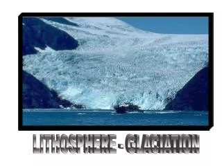
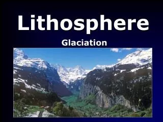
Glaciation • – is formation of glaciers in certain areas Many landforms are results of glacial erosion and deposition. • 2 main phases: cold periods – glacial – ice advanced southwards warm periods – interglacial – ice retreated northwards • Accumulation of ice – when a mass of ice is formed in a valley – formation of a glacier It can flow slowly downhill because of influence of gravity. E.g largest glaciers – in the Himalayas, Rocky mountains and the Alps Continuous mass of ice covering a large land surface – ice sheet.
Glacier as a system • Inputs: Precipitation, meltwater, sunlight, frost shaterring sediments • Processes: Storage of glacier ice • Output: Meltwater, ice, rock debris, water(gas) • A glacier moves into warmer areas where the ice is melt – 2 parts: Zone of accumulation(inputs>outputs) – glacier is growing, snowfall>melting Zone of abalation (outputs>inputs)- glacier is shrinking and retreating, melting>accumulation
Glacial erosion and transport • Cold polar glaciers - move very slowly • Warm, temperate glaciers – move faster because meltwater helps to reduce the frictional force • Glaciers can transport large amounts of rock debris – moraine - can be brought: on the surface of the glacier within the glacier along the glacier • Corrie – semi-circular, steep-side basin cut into the side of a mountain or at the head of a valley. • Corrie lake(tarn)- glacier that has come into valley and interglacial period it melted – only water remained – glacial lakes • Pyramid peak – 3-4 corries cutting back on each other • U-shaped valley – created by a glacier moving downslopes • Hanging valley – tributary glaciers flow into the main larger one. After malting these glaciers leave the valley hanging above them
Landforms • Drumlins – egg-shaped hills, formed under the glacuier by ice that has moulded boulder clayu into this distinctive shape • Eskers – long ridges of deposited material, formed by deposition from meltwater streams which flow under the ice. • Erratics – boulders transported over a long distance and deposited by glaciers. • Kames – small mounds of debris within ice, after thawing that dropped on the ground • Kettle holes – detached blocks of ice, after melting water5 is in a hollow and could be lost by evaporation an infiltration • Outwash plains – as meltwater streams flow away from the glacier, they begin to sort out material and deposit their load.