1 / 0

Wave & Mean Sea Level Rise Beach Change & Cliff Retreat Modeling

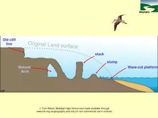
Wave & Mean Sea Level Rise Beach Change & Cliff Retreat Modeling. Shoreline Change Modeling. Beach Fluctuations & Cliff Erosion. Beyond Bathtub Modeling Costa Mesa, CA 19 December 2012 Reinhard E. Flick, PhD D. Bart Chadwick, PhD Adam P. Young, PhD John J. Helly, PhD

doris
Download Presentation

Wave & Mean Sea Level Rise Beach Change & Cliff Retreat Modeling

An Image/Link below is provided (as is) to download presentation Download Policy: Content on the Website is provided to you AS IS for your information and personal use and may not be sold / licensed / shared on other websites without getting consent from its author. Content is provided to you AS IS for your information and personal use only. Download presentation by click this link. While downloading, if for some reason you are not able to download a presentation, the publisher may have deleted the file from their server. During download, if you can't get a presentation, the file might be deleted by the publisher.

E N D

Presentation Transcript


  1. Wave & Mean Sea Level Rise Beach Change & Cliff Retreat Modeling Shoreline Change Modeling Beach Fluctuations & Cliff Erosion Beyond Bathtub Modeling Costa Mesa, CA 19 December 2012 Reinhard E. Flick, PhD D. Bart Chadwick, PhD Adam P. Young, PhD John J. Helly, PhD William C. O’Reilly, PhD Walter F. Crampton, PE Peter D. Bromirski, PhD Robert T. Guza, PhD TerraCosta Consulting Group SPAWAR Systems Center Pacific Scripps Institution of Oceanography University of California San Diego Flood Modeling
  2. Marine Corps Base Camp Pendleton & Naval Base Coronado Seal Team Training Marine Amphibious Training
  3. Wave & Mean Sea Level Rise Beach Change & Cliff Retreat ModelingModel Inputs Beach Profile & Width Data (Calibration) • Beach Profiles – 1950(v)-2010 (USACE, SIO, SANDAG, 13 Ranges, 8 MCBCP, 5 NBC) • Beach Width Calculated from Profiles Cliff & Terrace Topography, Geology, Rainfall • MCBCP – LiDAR Over-flights – 2001-2009, Semi-Annual (Only need one) • Rainfall Data (2001-2009) • Rainfall Projections – Downscaled 2000-2100 Waves – Local Energy, Runup & Closure Depth • Hs & Tp – Hourly Hindcast – 1979-2009 (Calibration) • Hs & Tp – WW-III Projections – 2000-2099, NCAR CCSM3, A2 Scenario, 3-Hr Total Water Level Statistics – “Active Beach” Profile • Tide + Non-Tide Residual + Wave-Driven Runup Mean Sea Level Rise Projection Scenarios • MSLR Scenarios – 2000-2100 (0.5, 1.0, 1.5, 2.0 m by 2100)
  4. SERDP Global MSLR + Tide + NTR + El Niño Scenarios 2086 Chadwick, Flick, Helly, Nishikawa, Wang, O'Reilly, Guza, Bromirski, Young, Crampton, Wild, and Canner, 2011. A Framework for Sea Level Rise Vulnerability Assessment for Southwest U.S. Military Installations, Proc. Oceans 11, Mar. Tech. Soc., Inst. Electrical and Electronic Eng. 2069 2046 Cayan, Bromirski, Hayhoe, Tyree, Dettinger, and Flick, 2008. Climate Change Projections of Sea Level Extremes along the California Coast, Climatic Change, (87)1.
  5. Wave & Mean Sea Level Rise Beach Change & Cliff Retreat ModelingModel Assumptions, Uncertainties & Constraints Beach Profile & Width • Shape similarity maintained • Upward & landward translation with MSLR • Closure depth – offshore profile extent • No hard-rock terrace • No account for structures • Bruun Rule overestimates MSLR erosion – See M&N • Bruun Rule overestimates wave erosion – See Guza Cliff & Terrace • Wave attack TWL initiation conditions • Erodibility limit • Slope similarity maintained Bruun Rule
  6. Bruun Rule – Basis for Projections Profile shape similarity maintained Translation upward & landward Rate of shoreline retreat depends on unit sand volume in the upland Active beach profile from TWL Cliff retreat initiation
  7. MCBCP Beach and Cliff Retreat Projection 20 m 100 m 15 m
  8. MCBCP Beach and Cliff Retreat Projection Young, Flick, O’Reilly, Chadwick, Guza, Crampton, and Helly, 2013. A decoupled profile sand balance retreat coastal model and application at Marine Corp Base Camp Pendleton, California for projected sea level rise, Climatic Change, in prep.
  9. Coronado Beach Short-Term Wave-Driven Beach Change Eeq = aS + b ΔE = E - Eeq ΔS = C±E½ (E - Eeq) Δt Empirical constants a, b, C+, C- NEEDBeach width data! Wave energy (from local wave hindcasts) ? ? ? Yates, Guza, O’Reilly, 2009. Equilibrium shoreline response: Observations and modeling, Jour. Geophys. Res. 1146.
  10. Naval Base Coronado – MSLR Beach Retreat Projection
  11. Naval Amphibious Base Coronado – Beach Retreat Projection (Present)
  12. Naval Amphibious Base Coronado – Beach Retreat Projection (2046)
  13. Naval Amphibious Base Coronado – Beach Retreat Projection (2069)
  14. Naval Amphibious Base Coronado – Beach Retreat Projection (2086)
  15. Naval Amphibious Base Coronado – Beach Retreat Projection (2100)
  16. Naval Base Coronado – Projected Shorelines & Flooding 100-yr Flood @ 2-m MSLR
  17. Wave & Mean Sea Level Rise Beach Change & Cliff Retreat ModelingModel Applications Beach Profile & Width • Basis for adaptation strategies • Training or recreation area loss projections • Runup & flooding projections • Facilities vulnerability (undermining) projections • Economic loss estimates • Nourishment cost estimates Cliff & Terrace • Basis for adaptation strategies • Training or recreation area loss projections • Facilities or development area loss projections • Facilities vulnerability (undermining) projections • Protection cost estimates
  18. The Navy’s La Jolla Realtor
More Related