Download
1 / 14
140 likes | 266 Views
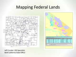
Cannabis Cultivation on Federal Lands in California. In-Progress Review 17 Feb 2004. Six Rivers 23,148 plants / 1.09 acres. Mendocino 24,798 plants 889,884 acres. National Forest Service. Bur. Land Management. Individual Public Land. Sierra 41,775 plants 1.3M acres. Stanislaus

E N D
Cannabis Cultivation onFederal Lands in California In-Progress Review 17 Feb 2004
Six Rivers 23,148 plants / 1.09 acres Mendocino 24,798 plants 889,884 acres National Forest Service Bur. Land Management Individual Public Land Sierra 41,775 plants 1.3M acres Stanislaus 42,716 plants 898,000 acres Sequoia 49,826 plants 1.1M acres San Bernardino 44,286 plants 660,000 acres Los Padres 34,673 plants 2M acres Cleveland 115,674 plants 460,000 acres Rising Drug Threat on Federal Lands 8 of the Top 10 National Forests for Cannabis Eradication are in California • Sharp escalation of organized drug production, trafficking, and related violence on NFS lands, especially in California • 2.7M plants seized (2000-03) • Meth labs/dump sites increasing • Cultivation plots larger, more sophisticated • 466,000 cannabis plants eradicated in CA worth $1.9B • 75% (350k) eradicated on public lands Sources: US Forest Service and California’s Campaign Against Marijuana Planting, Oct 2003
“Significant evidence of International Drug Trafficking Organizations operating on NFS lands” -- USFS Traffickers knowingly target Federal lands for their large remote and un-patrolled areas Drug-Related Violence Against Tourists / Park Officials Rising 1 Week in California National Forests: Sept 13-- Los Padres NF – Hunter shot at by growers Sept 14 – Sierra NF– Victim shot near 4,500-plant garden Sept 16 – Los Padres NF – FS and County Raid team fired on by growers Sept 16 – BLM Public Lands, Shasta Co., CA – CAMP and Shasta County deputies shoot out. Two growers shot and killed. Sept 18 – Mendocino NF – FS K9 attacked by growers. Suspects drop assault and high caliber rifles while fleeing Sept 19 – Butte County, CA – Butte County SD deputies shoot out, 2 growers shot and killed Sept 19– Mendocino County, CA - 34-year-old hacked to death with machete in marijuana garden In thousands Drug Threat on CA Federal Lands
ONDCP Requirement “In response to this threat, during the 2004 growing season, NDIC will conduct a limited-scope pilot project that seeks to estimate the amount of cannabis being cultivated on public lands in the state of California, with the eventual goal of producing an annual scientific estimate of total domestic cannabis cultivation and production.” --2004 National Drug Control Strategy
“… a limited scope pilot project…” • Define “public lands…” for survey • All Federal lands, forest lands, subset • Project will NOT touch • Indoor cultivation • Private lands • “Non-crop lands” (deserts, steep slopes, etc) • Military lands • Native American or Indian Reservations • Carefully scope project • End-product boundaries • Methodology • Investment
Preliminary Findings • Over 22 million acres of NFS lands in California • “Catch-22 Imagery” (resolution vs cost) • Affordable sensors lack resolution • Sensors with (possibly) adequate resolution are costly • Vital data exist, but may require full-scale collection • Ground truthing could be costly and complicate study • Project requires outside technical experience and infrastructure
Preliminary Conclusions • Design the highest value product using lowest risk/cost methods • Scope project in 2004 to fit timeline and resources • Narrowly define “Federal” lands • Expand scope in 2005 • Some critical work cannot begin until resources are in place • Technical personnel • Hardware / software / infrastructure • Minimize ground truthing without undermining survey credibility
Multiple and Parallel Sources • Replicate methodology / best practices used by other agencies for crop surveying • Collect data and intelligence from a wide range of sources • Synthesize/analyze data and intel to determine crop estimate and determine overall threat to public lands Other Data Dept of Interior Data Commercial Imagery Civilian Govt Imagery National Guard CD Data DEA DCE/SP Data USFS Enforcement Data CAMP Data
Envisioned End ProductContent, Use, and Distribution • Intelligence report: “Cannabis on Federal Lands in California: Threats and Estimated Cultivation” • Unclassified Executive Report (10 pages) • Interagency threat assessment • Growth/sophistication of cannabis trade on Federal lands • Probability estimate of CA Federal lands under cannabis cultivation • Restricted Annex (5 pages)
Scope Project DATA Collect Data Create Predictive Cueing Layer Plot survey areas, ground truth, produce estimate 5-Phase Methodology 1. Organize and Assess Feasibility • Define end-product • Seek agency “buy-in” • Determine resource needs 2. Pre-Survey Preparation • Define scope and methodology • Produce Predictive Cueing Layer Model • Imagery Analysis and Ground Truth • Plot targeted survey areas • Conduct ground truthing in survey areas 4. Data Analysis and Final Report • Incorporate LEA intelligence trend analysis • Extrapolate plot surveys • Estimate cultivation on all CA federal lands 5. Institutionalize for 2005 Survey
NDIC Director NDIC Gen Counsel Technical Exchange NDIC • Role/Responsibility • Overall project mgt • Interagency coord. • Prepare data request • Analytical production • Production of report Asst Director P/T NDIC Support GIS IA Statistician Non-Imagery Analysis Publication of final report PM Project Officer Imagery / GIS IAs DOI BLM, PS Insert roles/ responsibility USFS/USDA Enforcement, RSAC, ARS, NASS Methodology Threat Assessment Data collection Remote Sensing Support NGB CD, CHL Methodology Predictive Cueing Model Data collection Ground Truthing Support DEA DCE/SP Threat Assessment Intelligence Trends DCE/SP Data Ground Truthing Coord Other Agencies Project ManagementAgency Support and Functions
Progress to Date • Work is underway in all five phases • Meetings with 11 agencies • Valuable technical exchange • Strong support at staff and management levels • But need backing of agency leadership • Data collection continuing in CA • NGB plotting data--Predictive Cueing model on track • Draft “Data Request” (due completion 2/28) • Draft plan / methodology • NDIC hiring GIS Analyst • Identifying core issues for resolution
Road Ahead Next Steps • Acquire critical resources (personnel, work space) • Resolve legal issues • Finalize project scope, methodology, project plan • Brief ONDCP on proposed project scope/end product • Submit “data request” Initial Support from USDA and DOI • Offer DOI/USDA to be primary customers of end-product • GIS/Imagery Analysts (2) (USDA/RSAC) • Collect eradication data (with geo-coordinates) • Designate POC for planning team • Specific support to be requested within weeks