Download
1 / 46
470 likes | 803 Views
COASTS. Learning objectives: Explain wave and tide processes Understand linkages between wave/tide processes and sediment dynamics Describe coastal landforms and key processes of coastal landform development Explain coastal hazards and risk

E N D
COASTS • Learning objectives: • Explain wave and tide processes • Understand linkages between wave/tide processes and sediment dynamics • Describe coastal landforms and key processes of coastal landform development • Explain coastal hazards and risk • Describe and evaluate a range of coastal management strategies
Introduction • Approx 50 % of world population lives within 2km of the coastline • Many countries are dominated by coastal cities • The coastal zone = a dynamic geomorphological environment • Exhibiting change over a range of timescales • Adjusting to wave, tide and current processes • Important buffer between the marine and terrestrial environment • The coastal zone acts as an.. • Important ecological reserve • Economic resource • Communication corridor • Recreational playground
The Coastal Zone • The coast can be split into zones • Shore • Foreshore, backshore • Nearshore • wave are forced to break in the surf zone (the swash and backwash occurring at the shoreline) • Offshore • Coastal plain • Extends to the continental shelf
COASTAL PROCESSES
Waves • The movement of energy through a fluid • Sea waves- produced localised storm activity at sea • Swell waves- once the waves have left the generation area they lose height and energy to become swell waves • Wave form • Sinusoidal form with a number of definable components - wave crest, trough, height, steepness, period, frequency
Deep water waves • Wave height increases with wind speed, duration and fetch distance • Largest ever recorded wave = 34m (February 1933 in the Pacific) • Relationships between wave variables for water depths > ¼ of wavelength (L) L = 1.56 T2 indicates that small increases in wave period (T) cause large increases in L • Long waves move fast and lose little energy. Short waves move more slowly and dissipate a lot of their energy along their journey • Coasts facing open ocean receive long waves that have overwhelmed short waves • Deep water waves are deflected by the Corriolis effect.
Figure 17.3 Source: After Short, 1999
Deep water wave development • Evolve from small ripple into a full sea wave due to wind duration and frictional drag on the sea surface • On a calm sea, there is a small amount of frictional drag causing a ripple • The ripple increases sea surface area and therefore frictional drag • Air mass then has more frictional pull on the surface – increases wave amplitude • Ascending limb is pulled up by the push of the air mass • Descending limb is pulled down by the force of gravity • Height of the wave is directly proportional to the strength and duration of the wind passing over the surface • Continues to propagate long after the wind has ceased until energy is dissipated
Wave fields • Waves produced at different times and in different places and which vary in magnitude, direction and speed meet together • Become superimposed on each other • Produce complex wave fields • The patterns are cyclic – surf-beat • Short fetch coastlines • different waves arrive at the same time as choppy conditions since they have insufficient time to separate • Long fetch coastlines • long waves dominate, surf beat develops
Waves in shallow water • Waves change as they approach the coastline • A wave perturbs the water depth equal to ½ wavelength (to the wave base) • Shoaling occurs where the wave depth is greater than the water depth • Frictional drag of bed – wave slows • Wave length decreases but wave height increases • Steepens until unstable and breaks • Critical ratio of water depth to wave height between 0.6-1.2 (low waves travel further coastward before breaking)
…cont • Shoaling causes the orbital wave motion to become distorted • Angle of shore is important • Steep = waves break close to shoreline • Flat = waves break further offshore • Wave will spill, plunge, surge or collapse • Interaction of the wave with nearshore topography causes • Refraction • Reflection • Diffraction
Tides as waves • Tides = waves generated by the gravitational pull of astronomical bodies (esp. the moon) • Gravitational force of the moon causes reduction in Earth’s centrifugal force – effecting the oceanic surface mass • Predictable diurnal and monthly lunar cycle • Spring tides • Greater magnitude tides during new and full moon • Sun and moon pull along the same vector • Neap tides • Less magnitude tides during half moon phases • Sun and moon pull in opposite directions
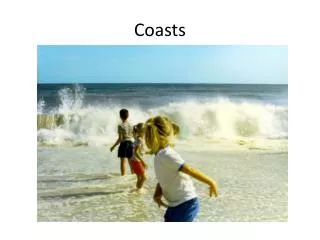
Waves and sediment • Swash and backwash = mechanism for movement of sediment up and down the beach • Longshore drift = sediment movement along the beach in swash and backwash at an angle • Longshore drift with no sediment supply from up the coast = net erosion • IMPORTANT FOR COASTAL MANAGEMENT
CURRENTS • Longshore currents • 10-20 cms-1 to 100cms-1 if wind direction is along shore • water moving along the beach trapped between breaking waves and beach slope • Rip currents • Water forced up the beach forces its way back down slope against breaking waves along line of least resistance • Strong circulation cell develops – dangerous • Tidal currents • due to rise and fall of the tide
Wave dominated coasts: erosional landforms • Coastal cliffs and shore platforms • Erosion = function of wave environment, local geology and coastal morphology • Marine and subaerial processes • Wave quarrying, abrasion, corrosion, wetting-drying, salt crystallisation, thermal expansion and contraction, biological activity • Landslides, rotational slumps, mudflows • Coastal retreat • Cyclical removal of fallen sediment from cliff base • May be a sediment source for downstream – longshore drift • Development of wave cut notches, caves, arches, stacks and blowholes • Complex feedback between cliff erosion, platform width and wave energy potential
Figure 17.11a Source: After Sunamura, 1992
Figure 17.11b Source: After Sunamura, 1992
Figure 17.11c Source: After Sunamura, 1992
Figure 17.12a Source: Ken Hamblin
Figure 17.12b Source: Dorling Kindersley
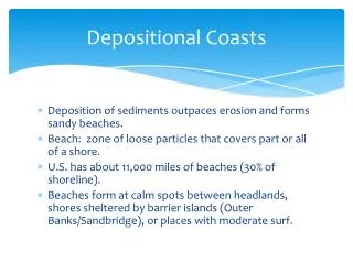
Wave dominated coasts: depositional landforms • Beach = accumulation of unconsolidated sediment • Dynamic equilibrium maintained because sediment is highly mobile • Beach profile • Function of coastal processes and sediment type e.g. wave type • Sediment size sorting • Topographical features – cusps, berms and ripples • Often coastal dune system above high tide • Beach planform • Curved features due to refraction • Spits, barriers islands and beaches, tombolos, lagoons
Figure 17.14 Source: After Goudie 1995
Figure 17.16 Source: After Bird, 2000
Figure 17.17 Source: After Waugh, 1995
Barrier formation hypotheses 1. Emerged-transgressive model • Offshore bars formed during last glacial low SL period • Bars have develop vertically and accumulated sediment as sea levels have risen 2. Submerged-transgressive model • Coastal dunes during lower sea level • Become isolated from mainland upon submergence 3. Emerged-standstill model • Barrier islands formed since post-glacial sea-level stabilised (4000 yrs ago) • However – many barrier island deposits are older than 4000 years ago
Wave dominated coasts: coral reefs • High energy wave environments • Delicate balance of erosion and biological construction • Corals are animals with plant like properties • Produce calcium carbonate build-up (thousand of yrs) • Zonation of coral forms across the reef • Forereef, reef flat, backreef • Different types • Barrier reefs, coral atolls (both with a lagoon), fringing reef • 2 main settings • (1) Continental shelf (2) Edges of volcanic islands (hot spots) • Threats • pollution, tourism, exploitation, climate change • Can vertical reef growth keep pace with rising sea levels?
Tide dominated coasts: estuaries • Coastal embayments from which rivers flow • Intertidal – tidal currents shift inlet channels • Receive sediment from sea and river • Form when net sediment movement is landwards (opposite to deltas) • Local sea level rise • Sub-dived into spatial facets • Upper estuary – fluvially dominated • Lower estuary – tidally dominated • Middle estuary – well mixed • Salt-fresh water mixing through diffusion and advection • Stratified estuaries • Partially-mixed estuaries • Lateral salinity gradients • Estuaries form becomes more similar over time
River dominated coasts: Deltas • Form at mouth of sediment rich fluvial channels • Deposition from the river • River velocity reduction causes carrying capacity loss • 3 main groups • Cuspate • Elongate • Estuarine • Delta morphology • Delta plain, topset beds, foreset beds, delta fronts, bottomset beds, pro-delta
Sea level change • Short term changes - Tidal, meteorological • Longer term changes - Isostacy, eustacy • Evidence for sea level change • Erosional and depositional landforms (e.g. wave cut notches, tidal flats) • Biological indicators (e.g. fossils) • Archaeological remains and historical records • Coastal response to sea level depends on nature of the coastline • Falling sea level • cause abandonment of coastal features • Rising sea levels • Causes drowning of coastal features, migration of mobile features (e.g. beaches), increased erosion • IPCC (1995) estimate by 2100 sea levels will rise by 50cm
Coastal management • Management problems • Sediment fluxes from natural and human activities, resource exploitation, pollution, coastal hazards • Coastal systems are very dynamic and have inputs, outputs and stores of sediment • If input of sediment is reduced – erosion results • Hard engineering • Sea walls - ignore natural beach profile changes • Artificial beaches and land reclamation - reduce incoming wave energy • Shore normal structures - groynes, jetties • Soft engineering • Problems encountered with hard engineering • Restoring natural protection (e.g. damaged dunes) • Managed retreat – where defences are not economically viable • Difficult decision making process – science, politics, economics
Figure 17.26 Source: Photo courtesy of Joseph Holden
Figure 17.27a Source: US Army Corps of Engineers
Figure 17.27b Source: US Army Corps of Engineers
Figure 17.28a Source: Photos courtesy of Joseph Holden
Figure 17.28b Source: Photos courtesy of Joseph Holden
Summary • Coastal areas are highly populated and constantly under threat from natural and human hazard • Wave forms and processes of refraction, reflection and diffraction are fundamental • Dynamic environment – rapid sediment flux • Wide range of coastal landforms depending whether wave, tidal or fluvially dominated • Coastal management strategies vary from hard engineering structures to doing nothing – site specific • Many engineering structures fail or cause problems elsewhere if the full range of coastal processes is not taken into account