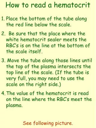
Download
1 / 20
210 likes | 498 Views
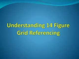
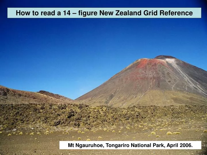
How to read a 14 – figure New Zealand Grid Reference. Mt Ngauruhoe, Tongariro National Park, April 2006. A full grid reference is 14 numbers : made up of a 7 figure Easting (numbers along the bottom) and a 7 figure Northing (numbers up the side). Method :

E N D
How to read a 14 – figure New Zealand Grid Reference Mt Ngauruhoe, Tongariro National Park, April 2006.
A full grid reference is 14 numbers: made up of a 7 figure Easting (numbers along the bottom) and a 7 figure Northing (numbers up the side)
Method: 1 - The first two figures to write down are the first two numbers of the small blue reference written with E at the end of it. Often in the bottom left corner. Emerald Lakes, Tongariro National Park, April 2006.
2 - The next two figures to write down are the usual grid numbers written horizontally on grid squares of the map.
3 - The last three figures to write down represent the proportion of the square travelled to get to the required feature. Usually you imagine the square is split into tenths, INSTEAD imagine it is split into a THOUSAND!
So with reference to the Tongariro topographic map (Lake Rotoaira side): To find ▲Hauhungatahi instead of writing 211… You would write e.g. 2721100 and add E for east. Red Crater, Tongariro National Park, April 2006.
4 - Then you need to follow the same method UP the map. The first two figures to write down are the first two numbers of the small blue reference written with a N at the end of it on the map. Often still in the bottom left hand corner. View SW towards Mt Tongariro and Mt Ngauruhoe, Tongariro National Park, April 2006.
5 - The next two figures to write down are the usual grid numbers written VERTICALLY up the side of the map.
3 - The last three figures to write represent the proportion of the square travelled up to get to the required feature. Usually you imagine the square is split into tenths, INSTEAD imagine it is split into a THOUSAND!
To finish 14 figure reference for ▲Hauhungatahi You would write e.g. 6216600 and add N for north.
Final 14 figure reference for ▲Hauhungatahi: 2721100 E6216600 N. View E towards Mt Tongariro and Mt Ngauruhoe, Tongariro National Park, April 2006.
Now use the following 14 figure grid references to locate other features of the Tongariro national park: • 2738050E 6227250N • 2752300E 6221500N • 2729350E 6219550N View E towards Mt Tongariro and Mt Ngauruhoe, Tongariro National Park, April 2006.
2738050E 6227250N – Mt Tongariro • 2752300E 6221500N – Disused Quarry. • 2729350E 6219550N – Crossroads, Whakapapa village.
Now write your own 14 figure grid references to locate THREE other features of the Tongariro national park: • 27. . . . . E 62 . . . . . N
With reference to the Waitakere (1:50 000 260 Q11) topographic map use the following 14 figure grid references to locate features at: 1 – 2644050E 6460220N 2 – 2640900E 6471000N 3 – 2653450E 6471550N 4 – 2651000E 6480500N 5 – 2637450E 6484450N
With reference to the Waitakere (1:50 000 260 Q11) topographic map use the following 14 figure grid references to locate features at: 1 – 2644050E 6460220N – Ninepin Rock. 2 – 2640900E 6471000N – Lion Rock, Piha. 3 – 2653450E 6471550N – Arataki Visitor Centre. 4 – 2651000E 6480500N – Swanson railway station. 5 – 2637450E 6484450N– Motutara Island.
Now write your own 14 figure grid references to locate THREE other features of the Waitakere Ranges area: 1 - 26. . . . . E 64 . . . . . N 2 – 3 –
Now use the following 14 figure grid references to locate other features in and around Auckland: • 2669500E 6464000N • 2668600E 6478900N • 2672300E 6484300N • 4. 2674300E 6469200N • 5. 2664200E 6485300N
2669500E 6464000N – Runway at Auckland Airport • 2666000E 6475100N – EGGS • 2672300E 6484300N – North Head • 2674300E 6469200N – Middlemore Hospital • 5. 2664200E 6485300N – Sugar Refinery
Now write your own 14 figure grid references to locate these 5 places: • The top of one tree hill • 2. The top of Rangitoto • 3. The museum in Auckland Domain • 4. Eden Park • 5. Bean Rock Lighthouse (North of Mission Bay)