Download
1 / 52
520 likes | 677 Views
An Overview of Tropical Cyclone Intensity Guidance Models Used by NHC. Michael Brennan, Chris Landsea, James Franklin NCEP/NHC Mark DeMaria, NOAA/NESDIS/StAR Andrea Schumacher, CIRA/CSU Bernard Meisner, NOAA/NWS/Southern Region. General Objectives.

E N D
An Overview of Tropical Cyclone Intensity Guidance Models Used by NHC Michael Brennan, Chris Landsea, James Franklin NCEP/NHC Mark DeMaria, NOAA/NESDIS/StAR Andrea Schumacher, CIRA/CSU Bernard Meisner, NOAA/NWS/Southern Region
General Objectives By the end of this module, you should be able to… • Describe the spectrum of NHC TC intensity models • Describe the general strengths and weaknesses of each type of model • Understand how intensity models are used in intensity forecasts • Have an overview of future intensity model improvements • Understand the limitations of tropical cyclone structure forecasting
Types of TC Intensity Forecast Models • Statistical Models: • SHIFOR (Statistical Hurricane Intensity FORecast) Based solely on historical information - climatology and persistence (Analog to CLIPER) • Statistical/Dynamical Models: • SHIPS (Statistical Hurricane Intensity Prediction Scheme): Based on climatology, persistence, and statistical relationships to current and forecast environmental conditions • LGEM (Logistic Growth Equation Model, variation on SHIPS, relaxes intensity to MPI) • Dynamical Models: • HWRF, GFDL, GFDN, GFS, UKMET, NOGAPS, ECMWFSolve the governing equations for the atmosphere (and ocean) • Ensemble, Consensus Models
Statistical Intensity ModelsSHIFOR (Statistical Hurricane Intensity FORecast) • Based solely on climatology and persistence • Originally developed in 1979 • Updated in 1988, revised and extended to 120 hr in 2003 • Base period 1967 – 1999 • Named storms (35 kt or greater) at least 30 n mi. from land • Predictor Variables • Julian day • Initial intensity, latitude and longitude • Intensity change (last 12 hrs) • Zonal and meridional storm motion (last 12 hrs) • Decay SHIFOR • Climatological decay rate over land using CLIPER track • SHIFOR, D-SHIFOR used as skill baseline
Statistical / Dynamical Intensity ModelsSHIPS (Statistical Hurricane Intensity Prediction Scheme) • Multiple regression model • Predictors from climatology, persistence, atmosphere and ocean • Atmospheric predictors from GFS forecast fields • SST from Reynolds weekly fields along forecast track • Predictors from satellite data • Oceanic heat content from altimetry • GOES IR window channel brightness temperatures • Decay SHIPS • Climatological wind decay rate over land
The SHIPS Model Predictors* (+) SST POTENTIAL (VMAX-V): Difference between the maximum potential intensity (depends on SST) and the current intensity (-) VERTICAL (850-200 MB) WIND SHEAR: Current and forecast, impact modified by shear direction (-) VERTICAL WIND SHEAR ADJUSTMET: Accounts for shear between levels besides 850 and 200 hPa (+) PERSISTENCE: If TC has been strengthening, it will probably continue to strengthen, and vice versa (-) UPPER LEVEL (200 MB) TEMPERATURE: Warm upper-level temperatures inhibit convection (+) THETA-E EXCESS: Related to buoyancy (CAPE); more buoyancy is conducive to strengthening (+) 500-300 MB LAYER AVERAGE RELATIVE HUMIDITY: Dry air at mid levels inhibits strengthening *Red text indicates most important predictors
The SHIPS Model Predictors (Cont…) (+) 850 MB ENVIRONMENTAL RELATIVE VORTICITY: Vorticity averaged over large area (r <1000 km) – intensification favored when the storm is in environment of cyclonic low-level vorticity (+) GFS VORTEX TENDENCY: 850-hPa tangential wind (0-500 km radial average) – intensification favored when GFS spins up storm (-) ZONAL STORM MOTION: Intensification favored when TCs moving west (-) STEERING LAYER PRESSURE: intensification favored for storms moving more with the upper level flow – this predictor usually only comes into play when storms get sheared off and move with the flow at very low levels (in which case they are likely to weaken) (+) 200 MB DIVERGENCE: Divergence aloft enhances outflow and promotes strengthening (-) CLIMATOLOGY: Number of days from the climatological peak of the hurricane season
Satellite Predictors added to SHIPS in 2003 1. GOES cold IR pixel count 2. GOES IR Tb standard deviation 3. Oceanic heat content from satellite altimetry (TPC/UM algorithm) Cold IR, symmetric IR, high OHC favor intensification
Factors in the Decay-SHIPS ModelCenter over Water Normalized Regression Coefficients at 48 hr for 2010 Atlantic SHIPS Model
Factors in the Decay-SHIPS ModelCenter over Land • Adjusts over-water SHIPS forecast using empirical exponential decay formula • Depends on time inland and fraction of area out to 110 km over land SHIPS and Decay-SHIPS forecasts for Hurricane Dolly starting at 00 UTC 23 July 2008 (Forecasted landfall at t=16 hr)
Regions with Most Favorable Shear Directions for Hurricane Ike(New SHIPS Model Predictor for 2009)
The Logistic Growth Equation Model (LGEM) • Applies simple differential equation to constrain the max winds between zero and the maximum potential intensity • Based on analogy with population growth modeling • Intensity growth rate predicted using SHIPS model input • More responsive than SHIPS to time changes of predictors such as vertical shear • More sensitive track errors • More difficult to include persistence
Logistic Growth Equation (LGE) Model dV/dt = V - (V/Vmpi)nV (A) (B) Term A: Growth term, related to shear, structure, etc Term B: Upper limit on growth as storm approaches its maximum potential intensity (Vmpi) LGEM Parameters: (t) Growth rate (from SHIPS parameters) MPI relaxation rate (constant) Vmpi(t)MPI (from SST) n “Steepness” parameter (constant) LGE replaced by Kaplan and DeMaria inland wind decay model over land
SHIPS and LGEM forecasts Includes predictor information Also includes Rapid Intensity Index SHIPS text output file Note: SHIPS and RII output available on-line in real time ftp://ftp.tpc.ncep.noaa.gov/atcf/stext
Dynamical Intensity Models GFS: U.S. NWS Global Forecast System < relocates first-guess TC vortex UKMET: United Kingdom Met. Office global model < bogus (syn. data) NOGAPS: U.S. Navy Operational Global Atmospheric Prediction System global model < bogus (synthetic data) ECMWF: European Center for Medium-range Weather Forecasting global model (no bogus) GFDL: U.S. NWS Geophysical Fluid Dynamics Laboratory regional model <bogus (spin-up vortex) GFDN: Navy version of GFDL model < bogus (spin-up vortex) HWRF: NCEP Hurricane Weather Research and Forecast regional model (vortex relocation and adjustment)
Dynamical Intensity Model Limitations Sparse observations, especially in inner core Inadequate resolution, especially global models Data assimilation on storm scale Representation of physical processes PBL, microphysics, radiation Ocean interactions Predictability
A Note on Bogusing • Since the globally analyzed vortex does not typically represent the structure of a true TC, “Bogussing” is often employed • Involves an analysis of synthetic data to describe the TC vortex • Can significantly affect the surrounding environment • Vertical shear • Creating and inserting a bogus is not straight forward • Forecast can be very sensitive to small changes in the bogus storm • Bogus storms tend to be too resilient during Extra-tropical Transition • Bogus retains warm core too long leading to poor intensity and structure forecasts
GFS, GFDL, HWRF Initial Vertical ShearHurricane Bill Aug 2009
Horizontal Resolution in Global Spectral Models • Horizontal fields expanded in 2-D wave function series • Associated Legendre functions in latitude • Fourier series (sines and cosines) in longitude • T indicates Triangular truncation (e.g., T400) • Latitude and longitude series contain same number of terms • Uniform resolution over the sphere • Rule of thumb for comparison to grid-point models • x = 40,000 km/3N, N=truncation number
The Geophysical Fluid Dynamics Laboratory (GFDL) Hurricane Model • Dynamical model capable of producing skillful intensity forecasts • Coupled with the Princeton Ocean Model (POM) (1/6° horizontal resolution with 23 vertical sigma levels) • Replaces the GFS vortex with one derived from an axisymmetric model vortex spun up and combined with asymmetries from a prior forecast • Sigma vertical coordinate system with 42 vertical levels • Limited-area domain (not global) with 2 grids nested within the parent grid • Outer grid spans 75°x75° at 1/2° resolution or approximately 30 km. • Middle grid spans 11°x11° at 1/6° resolution or approximately 15 km. • Inner grid spans 5°x5° at 1/12° resolution or approximately 9 km
The Hurricane Weather Research & Forecasting (HWRF) Prediction System • Next generation non-hydrostatic weather research and hurricane prediction system • Movable, 2- way nested grid (9km/27km; 42 vertical levels; ~75°x75°) • Coupled with Princeton Ocean Model • POM utilized for Atlantic systems, no ocean coupling in N Pacific systems • Vortex initialized through use of modified 6-h HWRF first guess • 3-D VAR data assimilation scheme • But with more advanced data assimilation for hurricane core • Use of airborne and land based Doppler radar data (run in parallel) • Became operational in 2007 • Under development since 2002 • Runs in parallel with the GFDL
2010 HWRF Upgrades Fixing known bugs in HWRF model (mostly related to radiation) Led to definition of new baseline configuration for HWRF Improved initialization (Additional data in GSI near the storm environment) Surface Physics Changes (Cd/Ch coefficients calculated based on observations) Gravity Wave Drag Parameterization
2011-2013 HWRF UPGRADE PLAN Data assimilation: Advanced initialization for hurricane core – assimilate airborne Doppler radar observations to define storm strength and storm structure (parallel in 2010) Continuous upgrades to HWRF hurricane core initialization through advanced 4-D data assimilation for winds and reflectivity Model resolution upgrades: Increase resolution: Horizontal resolution 1-6km, Vertical resolution ~100 levels (dependent on results of current studies). Hurricane ensembles: High-resolution hurricane model ensembles. Development of HWRF ensembles in progress Model Physics: Continuous upgrades to gravity wave drag parameterizations, sea spray parameterization, atmospheric/ocean boundary layer (fluxes), microphysics, deep convection (cloud-resolving scales), radiation Ocean coupling Replacement of POM with the HYCOM ocean model for 2011 Other upgrades: Coupling to land surface model with advanced surface physics for improved rainfall forecasts at landfall. Important input to hydrology and stream flow models which will address inland flooding. Advanced Wave Model (WAVEWATCH III) to forecast waves up to the beach, i.e. improve non-linear interactions, surf-zone shallow water physics, wave interactions with currents.
*HWRF *GFDL *Configurations for 2010 season
“Late” versus “Early” Models • “Late Models” = not available at synoptic time • Dynamical models are not usually available until 4-6 hrs after the initial synoptic time (i.e., the 12Z run is not available until as late as ~18Z in real time) • Results must be interpolated to latest NHC position (GFDL GFDI, NGPS NGPI, etc) • Late Models: All global models, GFDL, GFDN, HWRF • “Early Models” = available shortly after synoptic time • Early Models: LBAR, BAM, CLIPER, interpolated dynamical models
Consensus Intensity Models for 2010 • Fixed • ICON: SHIPS, LGEM, GFDL-I, HWRF-I • Variable • IVCN: SHIPS, LGEM, GFDL-I, HWRF-I, GFDN-I • Corrected • FSSE: Florida State Super Ensemble (experimental)
Intensity Guidance For Hurricane Ike18 UTC 06 Sept 2008 Objective Aid Time Intensity for 09L 090618 Intensity (kts) Forecast Period
Intensity Model Verification • Calculate difference between model maximum wind and best track maximum wind • Homogeneous sample • All models must be available for inclusion of a case • NHC verifies tropical and subtropical stages • Extratropical stage excluded • SHIFOR or D-SHIFOR model error is baseline for intensity forecast skill • Skill = 100*(ESHIFOR-Emodel)/ESHIFOR
Operational Atlantic Early Intensity Model Verification3-year Sample (2007-2009) OFCL shown for comparison Mean Absolute Error Forecast Skill
2009 Intensity Guidance - Atlantic Best model at every time period was statistical. Outstanding year for LGEM, which handles changes in the environment better than SHIPS. Official forecast offers value over the guidance early, but less so later in the forecast period. This was true in 2008 as well. May pay to stay closer to guidance (especially ICON) at the longer ranges.
2009 Intensity Guidance – E. Pacific Best model at every time period was statistical (DSHP or LGEM). Dynamical models did not have skill (but still contributed positively to the consensus). Skill levels much lower than for the Atlantic, but similar to last year. Official forecast offers value over the guidance early, but not so later in the forecast period. Large high bias at 120 h (last year there was a large low bias). This is consistent with strong southwest track bias.
Most Accurate Atlantic Early Intensity Models 1995-2009 (48 and 96 hr forecast) Year 1995 1996 1997 1998 1999 2000 2001 2002 2003 2004 2005 2006 2007 2008 2009 48-hr SHFRSHIP SHIP SHIP SHIP DSHP DSHP DSHP DSHP DSHP DSHPGHMIDSHP LGEM LGEM 96 hr SHIPGFSISHIPGFNIDSHPGFDIDSHPGHMILGEM Statistical Statistical-Dynamical Global-Dynamical Regional-Dynamical
Rapid Intensity Change • Max wind increase of 30 kt or more in 24 hr • Kaplan and DeMaria (2003) WAF definition • 5th percentile of Atlantic tropical cyclones • Can models predict RI? • Probability of detection • False alarm ratio (probability of false detection)
Example of Rapid Intensification Hurricane Wilma 2005 • Extremely rapid intensification • 65 kt at 12 UTC 18 Oct • 160 kt 24 hr later • Aircraft recon showed 4 km eye diameter near peak intensity • Challenging case for models with 9-km grid spacing
GFDL FORECAST FROM 10/17/05 18Z OBSERVED Early on 19 October, Wilma deepened at a rate of ~ 10 mb/hr! GFDL MODEL DID CAPTURE SOME OF WILMA’S RAPID DEEPENING
Example of Rapid Intensification Index VERIFYING: 160 KNOTS Prob of RI = 59.4% is 4.9 times the sample mean (12.1%) Note: SHIPS and RII output available on-line in real time ftp://ftp.tpc.ncep.noaa.gov/atcf/stext
Statistical Rapid Intensity Index (RII) • Uses subset of SHIPS predictors related to RI • Input to a discriminant analysis algorithm • Provides probability of RI (25-kt, 30-kt, 35-kt, and 40-kt) in next 24 hr
Probabilityof detection False alarm ratio Operational RII guidance performance 2008-2009
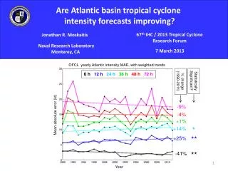
Atlantic Intensity Error Trends No progress with intensity.
Atlantic Intensity Skill Trends Little net change in skill over the past several years, although skill has been higher in this decade compared to the 90s.
Tropical Cyclone Surface Wind Structure • Wind structure represented by maximum radial extent of 34, 50 and 64 kt winds in 4 quadrants • NE, SE, SW, NW of storm center • NHC wind radii forecasts • 34, 50 kt wind radii to 72 hr • 64 kt wind radii to 36 hr • Storms with similar maximum winds can have very different structure • Wind structure impacts storm surge, damage and evacuations
Comparison of Hurricanes Dolly and Ike Pre-Landfall Wind Structure
Wind Structure Prediction Limitations • Physically processes controlling storm size not well understood • Statistical Models • Climatology and persistence input • Size varies with intensity and latitude • Global Dynamical Models • Inner core not resolved • Models predict some size variations of 34 kt wind • Regional Dynamical Models • Inner core partially resolved • Models predict some size variability • Model performance unknown since radii forecasts not routinely verified
Other Forecast Parameters in NHC Products Track Genesis (formation within 48 hr) Size (radius of 34, 50, and 64 kt) Storm Surge (within about 24 hr of landfall) Rainfall (provided by the Hydrometeorological Prediction Center) Tornadoes (provided by the Storm Prediction Center) 12-ft seas radii (provided by NHC’s Tropical Analysis and Forecast Branch and the Ocean Prediction Center)