Download
1 / 28
280 likes | 292 Views
Rapid 1-mm Survey of Airport Runways with Laser Imaging Technology. Kelvin C.P. Wang, Ph.D., P.E. University of Arkansas and WayLink Systems Co. Quintin Watkins, PE Prime Engineering, Inc. Atlanta, GA email: kcw@uark.edu , QWatkins@prime-eng.com.

E N D
Rapid 1-mm Survey of Airport Runways with Laser Imaging Technology Kelvin C.P. Wang, Ph.D., P.E. University of Arkansas and WayLink Systems Co. Quintin Watkins, PE Prime Engineering, Inc. Atlanta, GA email: kcw@uark.edu, QWatkins@prime-eng.com 2010 FAA Worldwide Airport Technology Transfer Conference April 20-22, 2010, Atlantic City, New Jersey, USA
Presentation Outline Needs of Airport Pavement Condition Survey Laser Imaging Technology Software Solutions Atlanta (ATL) Pavement Projects New Technology & Conclusions
Current Methods for Airport Runway Condition Survey PCI Based Visual Survey Predominant Method Worldwide: Walk Manual Survey Information: surface visual data Problems Daytime Survey Only, Runway Shutdown Human Errors: not easily correctable Time Consuming Issues in Consistency, Repeatability, et al No High-Definition Visual Data for Future Use
UK HARRIS (Highways Agency Road Research Info System ) • Multi-Function • Automation of Cracking Survey • Primarily Image Collection • Automated Detection and Classification of Cracks: Not in Production
Digital Highway Data Vehicle (DHDV, Old Generation)
The Parallel Computing Approach (Same General Structure for over 10 Years) Expanded View of the Distress Analyzer GPS DMI Camera CPU Core 1 CPU Core N Dual-CPU Acquisition Single Computer High bandwidth Data Link Project Manager for Parallel Processing Multi-CPU,Distress Analyzer
Computing and Positioning Evolving Computing Hardware Multiple CPU & Multiple Core, resulting in Higher Performance with Single Computer Reduction in Power Usage Positioning Devices DMI: for both the laser imaging triggering and distance calculation Differential GPS receiver: sub-meter accuracy at 10Hz frequency Supplemented with Hi-Frequency IMU for 1-inch dynamic accuracy
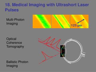
New Laser based Illumination 1-mm Resolution Complete Pavement Coverage, 4-meter Wide Any Weather Condition as long as Pavement is dry (Night Operation OK) No Shadows under Any Lighting Condition Uniform Image Quality
Airport Runway Surveys • Atlanta Airport, ATL
Passes with GPS Coordinates from Multiple Data Collection Passes
MHIS-Airport Software Interface Based on the architecture of Multimedia based Highway Information System (MHIS), MHIS-Airport is designed and made specifically for airport pavement condition survey.
Latest Developments • 3D Solutions (New & In Progress) • With laser illumination, 3D cameras to capture x, y, & z dimensions of pavement surface • Resolution: 1-mm for x & y plane, 0.5-mm for z (vertical) • Potential to Automate PCI Surveys • Challenges and Opportunities • Software Development, Key to Full Automation
Conclusion • Laser based Imaging • 1-mm Resolution (higher in the future) • Fully Implementable for Airport PCI Surveys • Data: Consistent, Repeatable, Retrievable • Good for Night Operation • 3D Development: Potential to Revolutionize Pavement Condition Survey