Download
1 / 15
200 likes | 348 Views
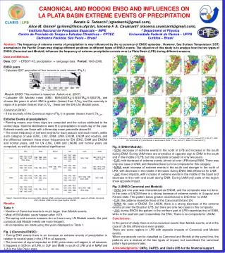
Evaluation of TRMM satellite precipitation product in hydrologic simulations of La Plata Basin. Fengge Su 1 , Yang Hong 2 , and Dennis P. Lettenmaier 1 1 University of Washington, Seattle, WA 2 NASA Goddard Space Flight Center, Greenbelt, MD. 1. Background.

E N D
Evaluation of TRMM satellite precipitation product in hydrologic simulations of La Plata Basin Fengge Su1, Yang Hong2, and Dennis P. Lettenmaier1 1University of Washington, Seattle, WA 2 NASA Goddard Space Flight Center, Greenbelt, MD
1. Background • The objective of this study is to evaluate the TRMM-based precipitation estimates, and their utility in hydrologic predictions. • Precipitation is the primary atmospheric input to hydrology models. • Satellite-based precipitation estimates show potential attractions for hydrologic predictions. • High resolution TRMM-based products are available to research community.
2. Data sets and methodology • The TRMM product evaluated in this study is the TRMM Multi-satellite Precipitation Analysis (TMPA) research product Version 6 3B42. • It combines precipitation estimates from multiple satellites, as well as gauge analyses, where available, at a 3-hour time step and 0.25° degree spatial resolution. • The data set covers the latitude band 50°N-S for the period 1998 to the delayed present. Huffman et al., 2006, The TRMM Multi-satellite Precipitation Analysis (TMPA): Quasi-Global, Multi-Year, Combined-Sensor Precipitation Estimates at Fine Scales (to appear in Journal of Hydrometeorology)
La Plata Basin and Gauged data (1998-1999) from NCAR and GDCN (Global Daily Climatology Network) station data Rain Gauge distribution in 1999 (676) Paraguay Parana Uruguay Rain gauge distribution in 1998 (846)
Methodology • Basin average precipitation estimates from the TRMM Satellite precipitation product (Version 6 3B42) and gauges are compared with each other at both daily and monthly time scales. • The Variable Infiltration Capacity (VIC) land surface hydrology model is forced by daily 3B42 and gauged precipitation over several subbasions of La Plata. The simulated streamflow is compared with each other and with available observed streamflow.
3. Precipitation evaluation Rrmse=60% Rrmse=13% Rrmse=134% Rrmse=15% Rrmse=44% Scattergramsof daily basin-averaged precipitation estimated from gauged and TRMM data.
Monthly Basin-averaged Precipitation Scattergrams of monthly basin-averaged precipitation estimated from gauged and TRMM data.
Daily time series of precipitation for basin 3861 1998 1999 mm/dy mm/dy 1 2 3 1 2 3 4 5 6 4 5 6 7 8 9 7 8 9 10 11 12 10 11 12 Month Month Gauged TRMM
Monthly time series of precipitation from gauged and TRMM 3B42 data for five subbasins (1998-1999).
Statistical evaluation over different subbasins Frequency Bias index FBI can indicate whether there is a tendency to underestimate (FBI<1) or overestimate (FBI>1) rainy events. Probability of Detection POD gives a proportion of observed rain events successfully estimated by the TRMM data. False Alarms Ratio FAR provides a measure of the 3B42’s tendency to estimate rain where none was observed.
4. Hydrological Modelling • Model features: • multiple vegetation classes in each cell; • energy and water budget closure at each time step; • subgrid infiltration and runoff variability; • and non-linear baseflow generation. The VIC (Liang et al, 1994;1996) model is a grid-based land surface scheme designed both for inclusion in GCMs, and for use as a stand-alone macro-scale hydrological model.
Observed Simulated with TRMM Prce. Simulated with gauged Prce. Daily streamflow for basin 3802 3802, Uruguay at Paso de Los Libres (Area: 189, 300 km2) m3/s m3/sm3/s Green VS. Black: Ef = 0.85, Er = 2% 1998 1999 Red VS. Black: Ef = 0.48, Er = 12% 1998 1999 Red VS. Green: Ef = 0.54, Er = 16% Nash-Sutcliffe efficiency (Ef) Relative error (Er) 1998 1999
Observed Simulated with TRMM Prce. Simulated with gauged Prce. Daily streamflow for basin 6301, 6598, and 6682 (a) 6301, Parana at Jupia (Area: 478,000km2) m3/s m3/sm3/s Red VS. Green: Ef = 0.73, Er = 4% 1998 1999 (b) 6598, Iguazu at Estreito (Area: 63,236 km2) Red VS. Green: Ef = 0.73, Er = -1% 1998 1999 (c) 6682, Paraguay at Ladario (Area: 459,990 km2) Red VS. Green: Ef = 0.72, Er = 18% Nash-Sutcliffe efficiency (Ef) Relative error (Er) 1998 1999
Observed Simulated with TRMM Prce. Simulated with gauged Prce. Monthly streamflow for the four subbasins m3/s m3/s m3/sm3/s (a) 3802, Uruguay at Paso de Los Libres (b) 6301, Parana at Jupia (c) 6598, Iguazu at Estreito (d) 6682, Paraguay at Ladario 1998 1999
5. Conclusion • The Version 6 3B42 provides good performance at monthly time scale. The daily estimates show a good performance for the low and medium precipitation thresholds. For higher thresholds, satellite estimates tend to overestimate the frequency of rain events, and show low POD and high FAR. • The 3B42-driven model results show a good ability in reproducing the timing of floods, and in representing the low peak flows, but tend to overestimate the high-flow peaks. • Despite the errors in the satellite-based precipitation estimates, this study provides encouraging results of using the TRMM 3B42 product in basin-scale hydrology predictions.