Download
1 / 2
30 likes | 169 Views
CTOH database Envisat, Topex, Jason 1, GFO. . Classical editing . 10 & 20 htz data: Linear interpolation : - Time - Geophysical corrections Instrumental corrections . Along track Loess filtering. Along track mean of sla-ster=f(t). Orbit errors. MOG2D Corrections : Ocean Tide

E N D
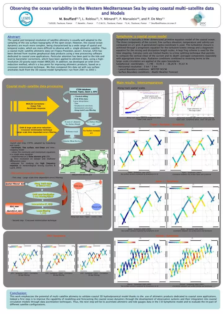
CTOH database Envisat, Topex, Jason 1, GFO • . Classical editing • . 10 & 20 htz data: • Linear interpolation : • - Time • - Geophysical corrections • Instrumental corrections • . Along track Loess filtering Along track mean of sla-ster=f(t) Orbit errors • MOG2D Corrections : • Ocean Tide • Barotropic response Orbit error localization 2 rms filtering f(t)-BF • Orbit & large scale error reduction : • Crossover minimization technique • Large-scale time-dependant errors filtering X years of altimetric Sea Surface Heigth Sea Surface Heigth at t Interpolation (f_2(t)) Sea Surface Anomaly at t Reference track Filtered orbit Spatial Filtered SLA Iterative process Loess filtering f_3(t) Altimetric Mean Sea Level SLA_new = SLA-f(t)+f_3(t) Coastal multi-satellite data processing • Main results: Intercomparaison • Along track spatial scales • Topex - Poseidon / Symphonie • Jason 1 / Symphonie • Envisat / Symphonie Small spatial scale Dynamic in altimetric data Good coherence on The large scales along track anomalie with different spatial filtering Topex (red) / Symphonie (blue), track 146 cycle 320 Along track spatial spectrum Symphonie (blue) / Topex ( red), track 9 Topex / Symponie ( year 2001) : Sea surface variance explained by Symphonie (in %) Topex / Symponie ( 2001) : Correlation between sea surface topex and symhonie Jason / Symponie (2002/2003) : Sea surface variance explained by Symphonie (in %) Jason / Symponie( 2002/2003) : Correlation between sea surface Jason and Symhonie GFO / Symponie ( 2001) : Correlation 60 day filtering GFO / Symponie ( 2002) : Correlation 60 day filtering GFO / Symponie ( 2003) : Correlation 60 day filtering Envisat / Symponie( 2002/2003) : Sea surface variance explained by Symphonie (in %) Envisat / Symponie( 2002/2003) : Correlation between sea surface Envisat and Symhonie Observing the ocean variability in the Western Mediterranean Sea by using coastal multi-satellite data and Models M. Bouffard(1,*), L. Roblou(2), Y. Ménard(3), P. Marsaleix(4), and P. De Mey(1) (1)LEGOS, Toulouse, France (2) Noveltis , France (3) C.N.E.S., Toulouse, France (4)L.A., Toulouse, France(1,*)bouffard@notos.cst.cnes.fr • Symphonie: a coastal ocean model • Symphonie is basically a three-dimensional primitive equation model of the coastal ocean. • The three components of the current, free surface elevation, temperature and salinity are computed on a C grid. A generalized sigma coordinate is used. The turbulence closure is achieved through a prognostic equation for the turbulent kinetic energy and a diagnostic equation for the mixing and dissipation length scales. A leap frog scheme is used for the time stepping. Calculus costs are limited thanks to a time splitting technique that permits to compute the vertical shear of the current and its depth-averaged components separately with appropriate time steps. Radiation conditions combined to restoring terms to the large-scale circulation are applied at the open boundaries • Geophysical coordinates : -1,74E – 10,95 E / 38,26 N – 45,61 N • Horizontal resolution : 3 km * 3 km • Lateral Boundary conditions : MFSTEP OGCM • Surface Boundary conditions : Aladin Weather Forecast Abstract: The spatial and temporal resolution of satellite altimetry is usually well adapted to the sampling of the sea surface topography of the open ocean. However, the coastal ocean dynamics are much more complex, being characterized by a wide range of spatial and temporal scales, which are more difficult to observe with a single altimetric satellite. Thus a coastal multi-satellite altimetric data set (Topex/Poseidon, Jason1, Envisat, GFO) has been derived from routine geophysical data products using a new processing software dedicated to coastal zone applications. Particular attention has been paid to the tide and inverse barometer corrections, which have been applied to altimetric data, using a high-resolution 2D gravity wave model (MOG2D). In addition, we developed an orbit error reduction method, which is a key point for improving altimetric products, based on a crossover minimization technique. We then compared this data set with sea surface anomalies built from the 3D coastal model Symphonie ( run from 2001 to 2003 ). • MOG2D model • (Lynch and Gray (1979), adapted by Greenberg and Lyard): • barotropic, free surface, non-linear and time-stepping model • solves the continuity and momentum equations in a single wave equation • implemented on a finite element grid (2D) • => finer resolution on steeper and shallower bathymetric zone • adequate for studying the high frequency response to meteorological forcing (Carrere & Lyard, 2003) O Orbit and large scale error reduction - Firts step : Large-scale time-dependant errors filtering - Second step : Crossover minimization technique MOG2D finite element grid Along track mean ( Topex - track9 )/ Time . GFO/ Symphonie Conclusion: This work emphasizes the potential of multi-satellite altimetry to validate coastal 3D hydrodynamical model thanks to the use of altimetric products dedicated to coastal zone applications. Indeed a first step is to improve the capability of modelling and forecasting the coastal ocean dynamics through the development of observation systems and their integration into coastal circulation models through data assimilation techniques. Thus, the next step will be to assimilate altimetric and tide gauges data in the 3 D Symphonie model and to evaluate the im:pact of different satellite configurations.