Download
1 / 38
380 likes | 500 Views
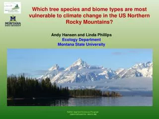
Biophysical and Land-use Controls on Biodiversity: Regional to Continental Scales. Andrew Hansen and Linda Phillips Montana State University Curt Flather Colorado State University. Joint Workshop on NASA Biodiversity, Terrestrial Ecology, and Related Applied Sciences May 1-2, 2008.

E N D
Biophysical and Land-use Controls on Biodiversity: Regional to Continental Scales Andrew Hansen and Linda Phillips Montana State University Curt Flather Colorado State University Joint Workshop on NASA Biodiversity, Terrestrial Ecology, and Related Applied Sciences May 1-2, 2008
Research Questions: 1: Which biophysical predictor variables are most strongly related to bird biodiversity potential in areas without intense human land use? 2: How are these patterns of biodiversity modified due to land use? 3: What geographic areas are highest priorities for conservation based on biodiversity modification resulting from land use change? Biophysical Potential (i.e. Energy, Habitat structure) Human Land Use (Land use, Home density) Current Biodiversity Value Conservation Priority/Strategies
Ecosystem Energy as a Framework for Conservation? • Key Hypothesis • Primary productivity, and the factors that drive it (climate, soils, topography), ultimately influence: • disturbance and succession • resources for organisms • species distributions and demographies • community diversity • responses to habitat fragmentation, land use, exotics • effectiveness of conservation Hawkins et al. 2003
Focus of This Talk • Which biophysical predictor variables are most strongly related to bird biodiversity potential in areas without intense human land use? • Which MODIS energy products best explain patterns of bird diversity across North America? • Does the relationship between birds and energy (slope and sign) differ between places of low, medium, and high energy?
History of Predictor Variables Used to Explain Species Energy Patterns -- -- -- -- -- -- -- -- -- -- -- -- -- -- -- -- -- 1960’s 1970’s 1980’s Remote Sensing advances 1990’s 1999 present Latitude (MacArthur 1972) Evapotranspiration (Currie 1987, Hawkins et al 2003) Ambient temperature (Acevedo and Currie, 2003) Precipitation (Chown et al., 2003) Water/Energy Balance (Hawkins et al 2003) AVHRR NDVI = (NIR - red) / (NIR + red) Thematic Mapper MODIS Land Surface Product Development NDVI EVI GPP (simulated from fpar, climate, cover type) NPP
Does NDVI have limitations that higher order products address? GPP NPP Not complete vegetation cover (backscatter) Dense vegetation (saturation) Phillips, L.B., Hansen, A.J. & Flather, C.H. (in press), Remote Sensing of Environment
What is the shape of the relationship? Why? richness richness energy energy Hypothesis: More individuals hypothesis (Wright, 1983, Preston, 1962; MacArthur & Wilson, 1963, 1967) Hypothesis: Competitive exclusion (MacArthur and Levins, 1964, 1967; Grime, 1973 1979, Rosenzweig 1992)
Energy as a framework for conservation If slope and sign vary among energy levels, conservation strategies should differ among low, intermediate, and high energy places. Protect harsh places But most of landscape is high in diversity, so more options for multiple use such as shifting mosaic approach to forest management; Identify and manage hotspots judiciously
Methods Response data • Bird richness from BBS data for years 2000-2005, estimated richness using COMDYN • Subset of routes (1838) to represent terrestrial natural routes (exclude human dominated land uses, water impacted) • Survey unit is a roadside route • 39.4 km in length • 50 stops at 0.8 km intervals • Birds tallied within 0.4 km • 3 minute sampling period • Water birds, hawks, owls, and nonnative species excluded in this analysis
Methods Predictor data Calculate both breeding season averages for NDVI, EVI and GPP and annual averages of NDVI, EVI, and GPP, NPP Annual Average MODIS GPP MODIS products used NDVI Enhanced Vegetation Index Gross Primary Production Net Primary Production
Methods Statistical analysis Stratify BBS routes by vegetation life from and density (MODIS VCF) Perform correlation analyses between predictors across vegetative strata and regression analysis between predictor and response variables across strata.
Methods Statistical analysis Perform regression analysis with linear, polynomial, spline and breakpoint spline models Perform simple linear regression analysis of four quartiles of GPP to determine slopes and significance Assess and control for effects of spatial correlation on significance levels and coefficients using generalized least squares analyses.
Results: Best Predictor? Correlation between NDVI and GPP across vegetation classes
Intrepertation: Best Predictor • Annual formulation better than breeding season for all predictors • Results suggest that GPP better represents primary productivity and bird richness than NDVI in low and high vegetation areas • GPP should be used especially in desert areas (bare ground) and dense forests (SE and PNW) • Results help explain differences in past studies on predictors and strength of relationships: will depend on vegetation density of samples. GPP NPP
Vegetation Coninuous fields Blue gradient - bare ground Red gradient - forest cover Green gradient - herbaceous cover
Results: Slope and Shape? R2 = 0.5346
Results: Slope and Shape? a= - 0.018 p<.001 a=0.083 p<.001 a=0.005 p<.036 a=0.013 p<.001
Interpretation: Slope and Shape richness richness energy energy Competitive Exclusion Hypothesis Predicts high canopy cover in overstory and lower habitat heterogeneity More Individuals Hypothesis Predicts higher habitat heterogeneity in areas of high richness
Species Diversity Springfield Cle Elum Disturbance Frequency High Low High Low High Low Site: Cle Elum R2=.30 P-value <.01 Site: Springfield R2=.16 P-value <.01 Disturbance Effects and Ecosystem Energy Huston 1994. High Springfield Intensity of Disturbance Diversity Low McWethy et al. in review. Low High Diversity increases with disturbance under high energy and decreases under low energy. Landscape Productivity Cle Elum
Next Steps: 1: Which biophysical predictor variables are most strongly related to bird biodiversity potential in areas without intense human land use? 2: How are these patterns of biodiversity modified due to land use? 3: What geographic areas are highest priorities for conservation based on biodiversity modification resulting from land use change? Biophysical Potential (i.e. Energy, Habitat structure) Human Land Use (Land use, Home density) Current Biodiversity Value Conservation Priority/Strategies
Next Steps: 1: Which biophysical predictor variables are most strongly related to bird biodiversity potential in areas without intense human land use? 2: How are these patterns of biodiversity modified due to land use? 3: What geographic areas are highest priorities for conservation based on biodiversity modification resulting from land use change? Vegetation structure from ELVS/GLAS Biophysical Potential (i.e. Energy, Habitat structure) Human Land Use (Land use, Home density) Current Biodiversity Value Conservation Priority/Strategies
Next Steps Vertebrates and NPP Humans and NPP This study. Balmford et al. 2001
Does the shape of the relationship vary with energy levels (geographically)?
Is the negative portion of the unimodal relationship real? Nugget .002 Sill .006 So using GLS, enter (800000, .25)
Do higher order MODIS products help us answer these questions? NDVI = (NIR - red) / (NIR + red)
Results: Best Predictor? Does NDVI have limitations that higher order products address? GPP NPP Not complete vegetation cover (backscatter) Dense vegetation (saturation) Phillips, L.B., Hansen, A.J. & Flather, C.H. (in press), Remote Sensing of Environment