Download
1 / 27
270 likes | 370 Views
Snow Hydrology and Modelling in Alpine, Arctic and Forested Basins. John Pomeroy and collaborators

E N D
Snow Hydrology and Modelling in Alpine, Arctic and Forested Basins John Pomeroy and collaborators Richard Essery (Edinburgh), Chris Hopkinson (CGS-NS), Rick Janowicz (Yukon Env), Tim Link (Univ Idaho), Danny Marks (USDA ARS), Phil Marsh (Env Canada), Al Pietroniro (Env Canada), Diana Verseghy (Env Canada), Jean Emmanual Sicart (IRD France and Centre for Hydrology Faculty, Researchers and Students Tom Brown, Kevin Shook, Warren Helgason, Chris DeBeer, Pablo Dornes, Chad Ellis, David Friddell, Warren Helgason, Edgar Herrera, Nicholas Kinar, Jimmy MacDonald, Matt MacDonald, Chris Marsh, Stacey Dumanski, Brad Williams, May Guan
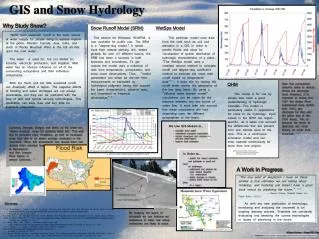
Mountain Snow summer snow water reserves vast water reserves in winter snowpack Snow depth in January Snow depth in June
Study Elements • Processes • Snow accumulation, structure and observation • Turbulent transfer to snow • Radiation effects on snowmelt under tundra shrubs and evergreen forests • Parameterisations • Blowing snow over complex terrain • Irradiance in complex terrain – longwave from terrain, shortwave shadows • Forest snow interception, unloading and sublimation • Sub-canopy snowmelt • SCA Depletion in complex terrain, • Contributing area for runoff generation in snowmelt period • Prediction • Wind and atmospheric modelling over complex terrain • Level of spatial complexity necessary in models • Regionalisation of CLASS parameters • Snow modelling contribution to MESH • CRHM • Arctic and sub-arctic snow hydrology, Wolf Creek & Trail Valley Creek • Alpine snow hydrology, Marmot Creek • Montane forest snow hydrology, Marmot Creek
Blowing Snow in Complex Terrain Inter-basin water transferTransport of snowto driftsSupports glaciers,late lying snowfields,hydrologicalcontributing areas
Granger Basin, Wolf Creek, Yukon Territory SF LiDAR used to develop topography and vegetation DEM Wind Direction NF Essery and Pomeroy, in preparation
Computer simulation of wind flow over mountains Windspeed Direction 3 km Granger Basin, Wolf Creek, Yukon
Bow River valley x x x x x x Kananaskis River valley x Marmot Creek Research Basin
Wind Direction Solar Radiation Alpine Hydrological Response Units Sublimation Snow Transport Ridge Top Snow Deposition South Face (top) North Face South Face (bottom) Forest Source Sink
20082009 Point Evaluation of Snowmelt Model
S facing slope N facing slope Frequency Distributions of SWE from LiDAR Depths and Measured Density SWE distribution within HRU fit log-normal density distribution
Snowcovered Area from Oblique Terrestrial Photographs, Aerial Photographs and LiDAR DEM
Snow-covered Area Depletion Modelling Four HRU (NF, SF, EF, VB) with modelled melt applied to SWE frequency distributions. Observed – using oblique photographyUniform – spatially uniform SWE distributions and applied melt rates for each HRU Variable SWE dist. – each HRU has a distinct distribution of SWE Variable snowmelt – each HRU has a distinct melt rate applied Fully distributed – each HRU has a distinct distribution of SWE and applied melt rate
Early Snowmelt Period - 2008 26-Apr 29-Apr 02-May 05-May Visualisation of Snowmelt Runoff Intensity Melt rates (mm/day) 0-5 5-10 10-20 bare forest cliff
Net Radiation to Forests: Slope Effects South Face Clearing North & South Face Forests North Face Clearing
Forest Snow Regime on Slopes Open slopes highly sensitive to irradiationdifference, forests are not
HRU Delineation • Driving meteorology: temperature, humidty, wind speed, snowfall, rainfall, radiation • Blowing snow, intercepted snow • Snowmelt and evapotranspiration • Infiltration & groundwater • Stream network
Streamflow Prediction 2006 Mean Bias = -0.13 all parameters estimated from basin data
Streamflow Prediction 2007 Mean Bias = -0.068 all parameters estimated from basin data
Conclusions • Appropriate process based models driven by enhanced remote sensing and good observations can be used to achieve adequate hydrological prediction in the alpine. • Model process and spatial structure must be appropriate to the complexity of the energy and mass exchange processes as they operate on the landscape. • It is possible to test for the most appropriate structure for balance between model complexity and predictive ability.