Download
1 / 34
340 likes | 584 Views
The National Map. Digital Mapping Techniques Workshop Columbus, Ohio June 12, 2006 Charles Hickman. Charles Hickman - Geographer - U.S. Geological Survey Mapping Liaison to Indiana and Ohio 6480 Doubletree Avenue Columbus, Ohio 43229 USA chickman@usgs.gov (614) 430-7768

E N D
The National Map Digital Mapping Techniques Workshop Columbus, Ohio June 12, 2006 Charles Hickman
Charles Hickman - Geographer - U.S. Geological Survey Mapping Liaison to Indiana and Ohio 6480 Doubletree Avenue Columbus, Ohio 43229 USA chickman@usgs.gov (614) 430-7768 NGPO http://www.usgs.gov/ngpo The National Map http://nationalmap.gov Find your state NGPO liaison at http://nmcatalog.usgs.gov/crreps/faces/crreps.jspx NSGIC Representatives http://www.nsgic.org
The National MapBased on Partnerships Local State Federal Credit to North Carolina
The National MapBackground • 55,000 maps / 33,000,000 hours / $1.6 billion • Valuable part of economy and infrastructure • Value is eroding due to age
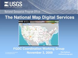
The National Map Distributed set of consistent, integrated, continually maintained, basic spatial data for the United States. Serve as the Nation's topographic map for the 21st century.
The National Map: Data Themes • Orthorectified imagery • Land cover • Elevation • Transportation (road, rail, other) • Hydrography • Structures • Boundaries (political & admin) • Geographic names
The National Map: Characteristics (1) • Seamless not quad based • Current to days or weeks, not years • Basic spatial data • Foundation for additional data stable feature identifiers as Velcro reach codes, addresses, linear referencing
The National MapCharacteristics (2) • Digital data and paper maps • GIS ready • User friendly • Online access, web accessible, 24-7 • Accurate, best available • Public domain, but link to other data • Standardized, consistent, modern datums
The National Map: Characteristics (3) • Integrated themes • Continually maintained • Transactional updates • Feature metadata • Roll back to versions for any point in time • Based on partnerships • Fed by state & local data and knowledge • National coverage • Variable resolution
The National Map:Blankets and Quilts • Blanket • Consistent • Seamless • Implementation can be more “rich” (aka complicated) • Slower to occur (integration takes time) • Quilt • Less consistent • Has seams • Implementation currently simple • Updates can occur more quickly (less or little integration) • More choices of data
Geospatial Web ServicesOpen Geospatial Consortium • OGC interface specifications • Web map service – returns a picture • Web feature service – returns geometry, attributes, and relationships • Web coverage service – returns raster-model data
National Hydrography Dataset (NHD) • Combine best of EPA RF3 and USGS DLG • 100K first • 24K now • Many partners • Geodatabase model
National Elevation Dataset (NED) Elevation data for • Mapping • Classifying land cover • Producing orthoimagery • Modeling hydrologic and wildland fire processes
National Elevation Dataset (NED) Elevation data for • Mapping • Classifying land cover • Producing orthoimagery • Modeling hydrologic and wildland fire processes
National Land Cover Dataset (NLCD) NLCD 2001 will be part of a land characterization database that also includes: • LANDSAT 7 imagery • Terrain slope, aspect, and elevation • Soil moisture • NLCD 1992 • Surface impervious and tree cover • Classification rules
Coordination& Standards Consistent & Current Content Data Discovery & Access The National Geospatial Program Office • Coordination, standards, policy – Federal Geographic Data Committee • Discovery and access – Geospatial One Stop • Integrated base data – The National Map
National Geospatial Programs Office • A Unified Approach to the NSDI • Align USGS national geospatial activities and responsibilities • Federal Geographic Data Committee • Geospatial One Stop • National Map • National Atlas • Reaffirm the direction of individual activities • Expand partnership offices • Assess USGS geospatial products and services
Disciplines of the U.S. Geological Survey • Geology (GD) • Water Resources (WRD) • Biological Resources (BRD) • Geography • GIO, includes NGPO
Charles Hickman - Geographer - U.S. Geological Survey Mapping Liaison to Indiana and Ohio 6480 Doubletree Avenue Columbus, Ohio 43229 USA chickman@usgs.gov (614) 430-7768 NGPO http://www.usgs.gov/ngpo The National Map http://nationalmap.gov Find your state NGPO liaison at http://nmcatalog.usgs.gov/crreps/faces/crreps.jspx
Ask USGS • Email ask@usgs.gov • Phone 1-888-ASK-USGS • Web http://ask.usgs.gov