Download
1 / 10
170 likes | 636 Views
Five Major U.S. Rivers. And Two Mountain Chains By: Melissa White and Lyndsey Robbins. GPS Standard SS3G1 The student will locate major topographical features. a. Identify major rivers of the United States of America: Mississippi, Ohio, Rio Grande, Colorado, Hudson.

E N D
Five Major U.S. Rivers And Two Mountain Chains By: Melissa White and Lyndsey Robbins
GPS Standard SS3G1 The student will locate major topographical features. a. Identify major rivers of the United States of America: Mississippi, Ohio, Rio Grande, Colorado, Hudson. b. Identify major mountain ranges of the United States of America: Appalachian, Rocky. NCSS Standard NCSS3 How to Analyze the Spatial Organization of People, Places, and Environments on Earth’s Surface Element 11: The World in Spatial Terms
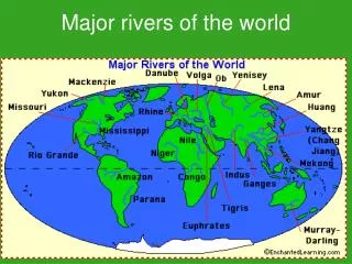
Colorado River • 1,450 miles long • Western Side of the Rockies • Ends in the Gulf of California (in Mexico)
Rio Grande River • Eastern Side of Rockies • Texas’s southern border with Mexico • 1,896 miles long
Ohio River • Part of Ohio’s service industry • States south of the Ohio were slave states • Connected to Lake Erie • Forms the states southern border and part of the eastern border • Ohio lowest point (sea level)
Hudson River • Connected to Lake Erie • New York’s longest river • 306 miles • Primary source is Lake Tear of the Clouds
Mississippi River • Cities got started as commercial ports and farmers markets. • Main designation is Lake Itasca • Flows every direction but west • Flows into the Gulf of Mexico • known for its tourist attractions (riverboats, casinos) • Cuts the nation into two parts • Forms borders on ten states • At 2,530 miles it is one of the longest rivers in the World
Appalachian Mountains • Contains the Appalachian trail which is the longest hiking trail in the United States. • Blue Ridge Mountains and Lookout Mountain are part of Appalachian Mountains • Extends into Canada • Erosion has worn them down
Rocky Mountains • Mostly rock at the tops • Includes Pikes Peak (14,115 ft above sea level) • Covers the middle third of the state • Covers over 3,000 miles from Northern Canada to New Mexico • Popular for hiking, skiing, hunting, and fishing.