Download
1 / 1
10 likes | 126 Views
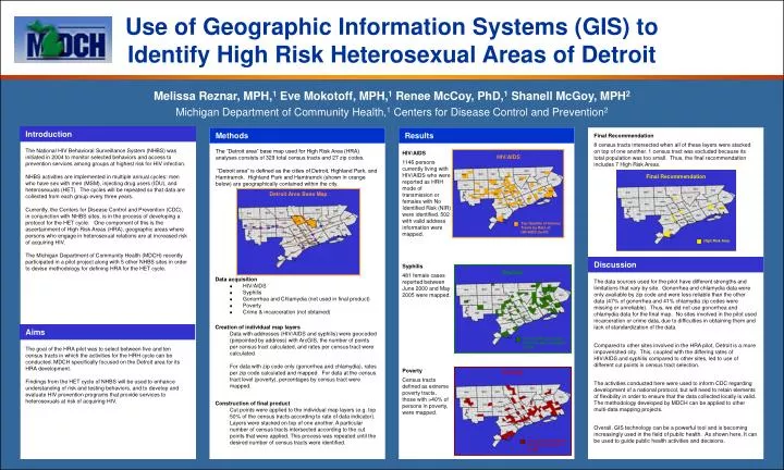
Use of Geographic Information Systems (GIS) to Identify High Risk Heterosexual Areas of Detroit. Melissa Reznar, MPH, 1 Eve Mokotoff, MPH, 1 Renee McCoy, PhD, 1 Shanell McGoy, MPH 2 Michigan Department of Community Health, 1 Centers for Disease Control and Prevention 2. Introduction.

E N D
Use of Geographic Information Systems (GIS) to Identify High Risk Heterosexual Areas of Detroit Melissa Reznar, MPH,1 Eve Mokotoff, MPH,1 Renee McCoy, PhD,1 Shanell McGoy, MPH2 Michigan Department of Community Health,1 Centers for Disease Control and Prevention2 Introduction Final Recommendation 8 census tracts intersected when all of these layers were stacked on top of one another. 1 census tract was excluded because its total population was too small. Thus, the final recommendation includes 7 High Risk Areas. Methods Results The National HIV Behavioral Surveillance System (NHBS) was initiated in 2004 to monitor selected behaviors and access to prevention services among groups at highest risk for HIV infection. NHBS activities are implemented in multiple annual cycles: men who have sex with men (MSM), injecting drug users (IDU), and heterosexuals (HET). The cycles will be repeated so that data are collected from each group every three years. Currently, the Centers for Disease Control and Prevention (CDC), in conjunction with NHBS sites, is in the process of developing a protocol for the HET cycle. One component of this is the ascertainment of High Risk Areas (HRA), geographic areas where persons who engage in heterosexual relations are at increased risk of acquiring HIV. The Michigan Department of Community Health (MDCH) recently participated in a pilot project along with 5 other NHBS sites in order to devise methodology for defining HRA for the HET cycle. The “Detroit area” base map used for High Risk Area (HRA) analyses consists of 329 total census tracts and 27 zip codes. “Detroit area” is defined as the cities of Detroit, Highland Park, and Hamtramck. Highland Park and Hamtramck (shown in orange below) are geographically contained within the city. HIV/AIDS 1146 persons currently living with HIV/AIDS who were reported as HRH mode of transmission or females with No Identified Risk (NIR) were identified. 502 with valid address information were mapped. HIV/AIDS Final Recommendation Detroit Area Base Map Top Quartile of Census Tracts by Rate of HIV/AIDS (n=57) High Risk Area Syphilis 481 female cases reported between June 2000 and May 2005 were mapped. Discussion Syphilis Data acquisition • HIV/AIDS • Syphilis • Gonorrhea and Chlamydia (not used in final product) • Poverty • Crime & incarceration (not obtained) The data sources used for the pilot have different strengths and limitations that vary by site. Gonorrhea and chlamydia data were only available by zip code and were less reliable than the other data (47% of gonorrhea and 41% chlamydia zip codes were missing or unreliable). Thus, we did not use gonorrhea and chlamydia data for the final map. No sites involved in the pilot used incarceration or crime data, due to difficulties in obtaining them and lack of standardization of the data. Compared to other sites involved in the HRA pilot, Detroit is a more impoverished city. This, coupled with the differing rates of HIV/AIDS and syphilis compared to other sites, led to use of different cut points in census tract selection. The activities conducted here were used to inform CDC regarding development of a national protocol, but will need to retain elements of flexibility in order to ensure that the data collected locally is valid. The methodology developed by MDCH can be applied to other multi-data mapping projects. Overall, GIS technology can be a powerful tool and is becoming increasingly used in the field of public health. As shown here, It can be used to guide public health activities and decisions. Creation of individual map layers Data with addresses (HIV/AIDS and syphilis) were geocoded (pinpointed by address) with ArcGIS, the number of points per census tract calculated, and rates per census tract were calculated. For data with zip code only (gonorrhea and chlamydia), rates per zip code calculated and mapped. For data at the census tract level (poverty), percentages by census tract were mapped. Aims Top Quartile of Census Tracts by Rate of Syphilis (n=54) The goal of the HRA pilot was to select between five and ten census tracts in which the activities for the HRH cycle can be conducted. MDCH specifically focused on the Detroit area for its HRA development. Findings from the HET cycle of NHBS will be used to enhance understanding of risk and testing behaviors, and to develop and evaluate HIV prevention programs that provide services to heterosexuals at risk of acquiring HIV. Poverty Census tracts defined as extreme poverty tracts, those with >40% of persons in poverty, were mapped. Poverty Construction of final product Cut points were applied to the individual map layers (e.g. top 50% of the census tracts according to rate of data indicator). Layers were stacked on top of one another. A particular number of census tracts intersected according to the cut points that were applied. This process was repeated until the desired number of census tracts were identified. Census Tracts Defined as Extreme Poverty (n=49)