Download
1 / 23
310 likes | 1.1k Views
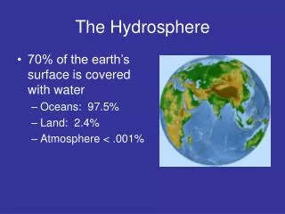
Structure of the Hydrosphere. The Biosphere is made up of 3 Parts. Click here for another great video About the biosphere. Click Image for a video about the Biosphere. The Structure of Hydrosphere. Oceans—96.5% of water found here Fresh water—3.5% of water found here.

E N D
The Biosphere is made up of 3 Parts Click here for another great video About the biosphere Click Image for a video about the Biosphere
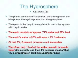
Oceans—96.5% of water found here Fresh water—3.5% of water found here Fresh water distribution: Ice: 1.762% Groundwater: 1.7% Surface Fresh Water: 0.014% Atmosphere and soil: 0.002% The Structure of Hydrosphere Click on the world for a video on oceans and rivers
Understanding Where Your Water Is Located—Oceans and Ice • What bodies of water hold the largest amount of water? • Oceans—the largest bodies of water on Earth (contain salt water only)
Understanding Where Your Water Is Located—Oceans and Ice (con’t) • What features house water as ice? • Icebergs: a large piece of freshwater ice floating in open waters • Glaciers: any large mass of ice that moves slowly over land • *permanent snow areas also “house” water as ice Click on iceberg for video
Fresh Water Locations—Surface Water • What is the difference between a watershed and a river basin? • Both terms describe land that drains into a river, stream or lake • River Basin: the term used to describe an area that drains into a large river • Watershed: the term used to describe an area that drains into a smaller river or stream
Fresh Water Locations—River Basins and Watersheds • Larger river basins are made up of many interconnected watersheds • Example: Cape Fear and Neuse River Basins are made of many small watersheds • The water in a watershed runs to the lowest point—a river, stream, lake, or ocean
Fresh Water Locations—Rivers, Streams, and Lakes • What is a river? • A large channel along which water is continually flowing down a slope—made of many streams that come together • What is a stream? • A small channel along which water is continually flowing down a slope—made of small gullies • What is a lake? • A body of water of considerable size contained on a body of land
Major Rivers in NC Shaded Areas are the Different River Basins in North Carolina
Fresh Water Locations--Groundwater • What is groundwater? • The water found in cracks and pores in sand, gravel and rocks below the earth’s surface Click the Picture to view a video about Groundwater
Fresh Water Locations—Groundwater (con’t) • What is an aquifer? • A porous rock layer underground that is a reservoir for water Click on Picture to View a Video on Earth’s Water Supply
Other Surface Waters • What is a wetland? • An area where the water table is at, near or above the land surface long enough during the year to support adapted plant growth • What are the types of wetlands? • Swamps, bogs, and marshes • Swamp: a wetland dominated by trees • Bogs: a wetland dominated by peat moss • Marshes: a wetland dominated by grasses
Swamps, Bogs, Marshes in NC Great Dismal Swamp Beech Creek Bog Click Here to Watch a Video about how ancient Indians located Groundwater Bodie Island Marsh
Technology and the Hydrosphere • Remote Sensing - allows scientists to use satellites to monitor all areas of Earth • Hundreds of km above Earth’s surface • Detects changes in light and energy that are not visible to the human eye • Computers can covert to colors Example: temperature
Technology and the Hydrosphere (con’t) • Remote Sensing (con’t) • Uses: • Amounts and location of phytoplankton • Amounts of dissolved organic compounds • Location and amount of sediment • Temperatures (predict El Nino) • Buoys can be used to record temperatures, winds, currents, and air temperatures
Technology and the Hydrosphere (con’t) • GPS (Global Positioning System) – uses satellites to pinpoint locations on Earth • Calculates latitude and longitude at 3 or more sites Click to picture to see how GPS works
Technology and the Hydrosphere (con’t) • GIS (Geographic Information Systems) – mapmaking software that creates different map layers for the same area • Each layer contains different information • Example: Mapping a Watershed would include different layers, each showing something different like temperature, nitrate levels, pH, dissolved oxygen, pollution • Using all the layers, the location of possible polluters can be determined
Technology and the Hydrosphere (con’t) Click on the image to watch a video about GIS