Download
1 / 31
310 likes | 402 Views
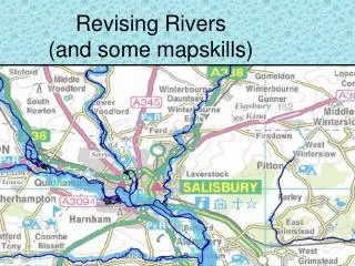
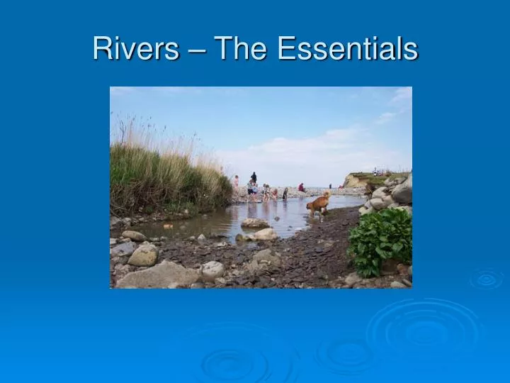
Rivers – The Essentials. Long Profile. A long profile can tell you how a river and its valley changes from source to mouth. Cross Profile. A cross profile is an outline of how a river or valley would look like if you cut a section of it vertically e.g. across a line from A to B.

E N D
Long Profile A long profile can tell you how a river and its valley changes from source to mouth.
Cross Profile A cross profile is an outline of how a river or valley would look like if you cut a section of it vertically e.g. across a line from A to B. Why do they change? Think about the effects of changes in gradient, processes of erosion, deposition, velocity etc.
Processes of river erosion Abrasion/Corrasion This is the process by which the bed and banks are worn down by the river’s load. The river throws these particles against the bed and banks, sometimes at high velocity. Hydraulic Action This process involves the force of water against the bed and banks. Corrosion This is the chemical action of river water. The acids in the water slowly dissolve the bed and the banks. Attrition Material (the load) carried by the river bump into each other and so are smoothed and broken down into smaller particles.
Processes of transportation Transportation Rivers pick up and carry material as they flow downstream. A river may transport material in four different ways: Solution - minerals are dissolved in the water Suspension - fine light material is carried along in the water Saltation - small pebbles and stones are bounced along the river bed Traction - large boulders and rocks are rolled along the river bed
Deposition • What is it? • Deposition is where the river dumps or leaves behind material that it has been carrying. • Why does material get deposited? • The largest material gets deposited first as this is the heaviest to carry • Material will also get deposited if there is a fall in the velocity (speed) or amount of water (discharge) in a river. • When there us a change in gradient e.g. lower section of a river long profile is much flatter • When a river enters a lake or sea
Upper course river features Waterfall formation Waterfalls are formed where a river flows over a band of hard rock next to a softer rock. The softer rock is eroded by hydraulic action and corrasion. The power of the water creates a deep plunge pool below the waterfall and undercuts the softer rock until the waterfall eventually collapses. This causes the waterfall to retreat upstream forming a gorge.
Middle and lower course features Meanders A meander is a bend or curve in the river. The formation of meanders is due to both deposition and erosion. The high velocity of the water erodes and undercuts the river bank on the outside of the bend where water flow has most energy (deeper, so less friction), forming a river cliff. On the inside of the bend, where the river flow is slower (shallower, so more friction), material is deposited forming a slip-off slope (river beach)
Outside of meander Neck Oxbow lake formation Erosion on the outside of the bend of a meander and deposition on the inside make the meander wider and the neck gets narrower. Often during a flood, the river breaks through, creating a new straight course and deposition (silt) seals off the old meander to form an oxbow lake. Over time, the water in the oxbow lake will evaporate (summer months) and disappear. Mud and silt will also get washed into the oxbow lake when it rains, so it will fill up and eventually vegetation will grow where water used to be. There will be a slight scar in the landscape left behind.
leveés clays and silts sands The formation of levees When a river overflows, the velocity decreases (water flow on flood plain – shallower/more friction) and it begins to deposit its load, the largest material first (as it has more energy nearer the channel – deeper/less friction/higher velocity). Smaller materials like sands, clays and silts get deposited further away from the river channel and onto the flood plain as they are easier to transport (the river does not have the energy to transport large material – velocity is reduced in shallower water). After repeated floods, high banks called levees are formed at the sides of the river.
Formation of flood plains A flood plain is the flat area of land (hillsides mark its boundary) where the river meanders across, either side of a river. During periods of high rainfall, a river will overflow its banks and deposit sediment (very small material e.g. silt) as the water evaporates and recedes. Over the years, this cycle will help build a layer of silt on the flood plain. This material is very fertile and excellent for growing crops.
Where does rainwater go? Think of the drainage basin hydrological cycle (above) when answering a question about hydrographs.
Hydrographs Basin lag time Peak flow 3 Rising limb Overland flow Recession limb 2 mm Discharge (m3/s) 4 Through flow 1 3 2 Base flow 0 12 24 36 48 30 72 Hours from start of rain storm
What is a hydrographand why are they constructed and analysed? What is a hydrograph? A hydrograph is a line graph drawn to show the discharge in a river after a period of rain. Why are they used? They are used by river engineers to show how a particular river responds to a period of rainfall and can help with predicting floods and also preventing them.
Key elements of a hydrograph • Bars = rainfall • Line = discharge (amount of water in the river) • Rising limb = rising river as result of floodwater • Peak flow/discharge = maximum discharge of river • Recession/falling limb = falling level of river • Lag time = time difference between peak rainfall and peak discharge • Base flow = normal flow of river • Area of hydrograph above base flow = overland flow (surface run off + throughflow)
Factors resulting in different shaped hydrographs • Rock type: a. impermeable – doesn’t let water infiltrate through it e.g. clay. Leads to fast rising/flashy (responds quickly)hydrograph b. permeable – it lets water through e.g. sandy soil / porous rocks ) c. Porous – rocks with small holes in e.g. limestone/chalk/sandstone • Land use: • forest/woodland – intercepts rainfall. With stemflow, water will slowly infiltrate into the ground, leading to a slower rising hydrograph • Agriculture – are crops growing or have they been harvested, leaving behind bare soil. The resulting hydrographs would look very different • Urbanisation (town/city area). Concreted areas are impermeable, resulting in rapid surface run-off to drains and then rivers • Gradient– is the river surrounded by steep, rocky sides (rapid surface run-off) or are the sides gently sloping (greater infiltration)?
Flooding • What are the causes of a river flooding: • PHYSICAL (natural) • Prolonged rainfall • Heavy rainfall • Snow melt • Relief (height and shape of land e.g. steep) HUMAN (man made) • Deforestation (cutting down trees) • Urbanisation (towns/cities expanding through construction) • Dams breaking
Boscastle August 2004 Mozambique Floods 2000 Case Study of a flood in a LEDC Case Study of a flood in a MEDC
Boscastle Flood 2004, UK (MEDC)– causes and effects • Causes: • 400 mm of rain fell in one afternoon • Really torrential thunderstorm with 60mm rain in 2 hours • Steep sided valleys lead to rapid run-off • Below Bodmin Moor (area high land where there was very heavy rainfall) • Impermeable rocks and thin soils meant rainwater ran off • High tides held river water back, flooding coastal area Effects: • 58 properties flooded and 4 demolished • 100 people rescued by 7 helicopters (no one killed) • 1000 residents and tourists were affected and had to leave to find temporary shelter) • 84 cars wrecked with 34 washed out to sea • 29 out of 31 Cornwall fire stations occupied and had to stay 7 days • Total cost of damage about £2 million
Mozambique Floods 2004, Africa (LEDC) – Causes and effects • Causes: • Mozambique is a lowland country with many rivers • 75% of Mozambique’s annual rainfall (1100mm) fell in only 3 days • Mozambique suffered a long drought (no rain) before the rains came i.e. the ground was like concrete and not able to soak up water • Tropical cyclones (storms) Eline and Gloria brought driving rain, strong winds and storm surge waves to the region Effects: • Crops were flooded and ruined and roads were damaged and destroyed • Many children suffered stomach cramps and later cholera as a result of hunger and drinking water that got polluted. Pools of stagnant water provided ideal breeding grounds for malaria carrying mosquitos • Muddy water lay up to 5m deep and 50km across Mozambique • Villages were washed away when the overspill gates of the Kariba Dam were opened • At one point there is so much water in the rivers that 8m waves rush across the Limpopo and Icomati rivers
Responses to the floods in Boscastle and Mozambique • Boscastle: • Plant trees on upper steep slopes to intercept rainfall • Straighten the river channel and line it with concrete to get water out of the river system to the sea as quickly as possible • Prevent rebuilding on the flood plain around the harbour • Install control dams in the upper valley • Mozambique: • South Africanprovided 6 helicopters who helped save 8000 lives in a week. Mozambique only has one helicopters. 4 Puma helicopters are flown out from Europe • Britain cancelled all debts owed by Mozambique and gave £5.8 million in donations • The United Nations appealed for £9.1 million in emergency aid for Mozambique • Charities like OXFAM sent ‘family emergency packs’ • Tents, plastic sheets, blankets, water tanks etc. are shipped from many countries • Medical kits e.g. basic antibiotics, water purification tablets and medicines are ‘donated’
Approaches to flood management? Since the serious 1993 Mississippi floods (USA), some scientists began asking whether rivers should be allowed to flood naturally. There are 3 main strategies in response to controlling rivers which flood: 1.HARD ENGINEERING (the use of technology to try to control rivers) 2.SOFT ENGINEERING (trying to work alongside/with the river 3.Do nothing (this is often necessary in poor countries)!
How can floods be managed? • HARD ENGINEERING • Sluice gates (biggest being Thames Barrier) • Building dams • Straightening the river (straighten meanders) • Build up the river banks – naturally and artificially by concrete (levees) e.g. Exeter • Flood relief channels e.g. Exeter • Dredging – digging the river bed deeper • SOFT ENGINEERING • Afforestation (planting trees) • Sandbags • Flood warnings/preparation e.g. evacuate • Flood plain zoning • ‘DO NOTHING’
How do some of these approaches work? • DAMS – concrete walls (dams) are built across a river to form a reservoir and control the amount of water in a river i.e. water can be stored during times of high precipitation and when the threat of river flooding is greatest • STRAIGHTENING OF MEANDERS – rivers have a mind of their own and will often meander across a flood plain. Therefore, water in a meander takes longer to clear an area than water in a straight section of river (so, increasing the possibility of a river bursting its banks) • FLOOD WARNINGS/PREPARATION – telling people in advance of a flood gives them valuable time to prepare for it. The Environment Agency identifies areas at risk of flooding and issues warnings. This allows people time to take possessions upstairs; turn off gas, water and electricity; gather together important papers (passport etc.) and take some basic precautions against flooding e.g. sandbag front door • FLOOD PLAIN ZONING – this occurs where the flood risk across different parts of the floodplain is assessed and resulting land use takes this into account e.g. lowest value land use will be found nearest the river e.g. pasture for grazing and playing fields and highest value land use e.g. industry and housing will be located furthest from a river
COSTS (bad) ANDBENEFITS (good)OF DIFFERENT APPROACHES • HARD ENGINEERING • Projects include building dams, levees etc. These methods tend to give immediate results and control of a river • Problems can worsen in the future or create unforeseen problems e.g. silt (mud) building up behind dams, pollution/waste from shipping, industry and cities (Three Gorges Dam, China) • Results in big changes to a river and the surrounding landscape • Expensive
COSTS (bad) ANDBENEFITS (good)OF DIFFERENT APPROACHES • SOFT ENGINEERING Projects include: • Letting wetlands (e.g. marshy areas) store water • Dividing up the flood plain into zones for different uses e.g. grazing land, crops, settlements and roads. This is called flood plain zoning. This controls what is built on a floodplain, so that areas that are at risk of flooding have low value land uses. • Planting trees – which can increase lag times • Flood warnings and preparation can allow people time to take possessions upstairs; turn off gas/electricity; gather up important papers • This is cheaper and more environmentally sustainable (can do this for years without any harm to environment).
How is water supply managed in the UK? • Background • In the NW, water supply exceeds water demand but in the SE, demand exceeds supply. There are many reasons for this e.g. heavy annual rainfall, more reservoirs, less evaporation (summer), fewer larger cities (no London!) and less demand from farming. • What is water stress? • Water stress is when the amount of water does not meet that required. This may be due to an inadequate supply at a particular time or may relate to a water quality problem. • Why has water demand increased in the UK? • Increased number of households and population in certain areas • A more affluent (financially better off) lifestyle increases the demand for water e.g. dishwashers (use more water than hand washing), Jacuzzis, spas etc. • Growth of car ownership i.e. washing their car • More people using hoses to water gardens • The demand for foodstuffs e.g. salads, fruit and vegetables out of season, which need to be washed and cooked i.e. increasing the use of water • Less people sharing a house (marrying at an older age)
Is there a solution? • A traditional solution to the problem of demand problems has been to transfer water from areas of high supply (high, wet areas e.g. Wales ) to those areas of deficit (less wet areas with many towns and cities e.g. Liverpool, NW England) • CASE STUDY: LAKE VYRNWY, WALES • What have been the costs (bad features/impacts) and benefits (good/features/impacts) of the dam development? • Economic (money/wealth) = Local people have jobs and income as a result of: • Cafes, an RSPB Shop, several gift shops which sell local crafts and produce, and a Tourist Information Centre which sells booklets and pamphlets not just on the Lake but for most of North Wales and Snowdonia • The village is a great position for tourists and thousands visit every year. T • There is sailing and fishing on the Lake • Social (people) = 2 chapels, 3 inns, 10 farmhouses, and 37 houses were lost under the reservoir when the dam was constructed. • Environmental (surroundings) = The surrounding area has been designated as a National Nature Reserve, a Site of Special Scientific Interest, a Special Protection Area and a Special Area of Conservation.
Useful websites - animations http://www.school-portal.co.uk/GroupDownloadFile.asp?file=21604 (waterfall animation) http://www.school-portal.co.uk/GroupDownloadFile.asp?file=21394 (flood plain and levees) http://www.geography.ndo.co.uk/animations3.htm (processes of erosion) http://www.cleo.net.uk/resources/displayframe.php?src=309/consultants_resources%2F_files%2Fmeander4.swf (meander formation) http://www.bbc.co.uk/schools/gcsebitesize/geography/riverswater/floodingrev4.shtml (Mozambique floods) Geography at the movies (video clips) -http://www.geographyatthemovies.co.uk/ (Coasts)