Download
1 / 13
130 likes | 323 Views
Land cover mapping of Asia , Central Asia, and Middle East for GLC2000 project. Ryutaro Tateishi, Hiroshi Sato, and Zhu Lin Center for Environmental Remote Sensing (CEReS), Chiba University Japan E-mail: tateishi@ceres.cr.chiba-u.ac.jp. GLC 2000 – “FIRST RESULTS” WORKSHOP

E N D
Land cover mapping of Asia,Central Asia, and Middle East for GLC2000 project Ryutaro Tateishi, Hiroshi Sato, and Zhu Lin Center for Environmental Remote Sensing (CEReS), Chiba University Japan E-mail: tateishi@ceres.cr.chiba-u.ac.jp GLC 2000 – “FIRST RESULTS” WORKSHOP JRC – Ispra, 18-22 March 2002
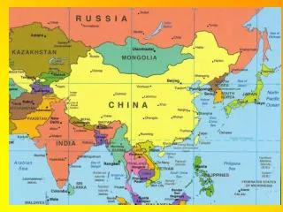
Area Coverage Asia 5-57 North lat. 60-150 East long. Central Asia 35-60 North lat. 45-90 East long. Middle East 10-45 North lat. 25-65 East long. Used data VEGETATION S-10 NDVI data sets
Legend Based on “The GLC2000 global legend Version 1.0” by H.J.Stibig Ground truth Totally 86 small regions were selected as ground truth sites. (43 sites for Asia, 30 sites for Central Asia, and 13 sites for Middle East) Number of land cover classes of ground truth is 20. 17classes are from Stibig’s “The GLC2000 global legend Version 1.0” , and 3 additional classes. Classification Maximum Likelihood method for monthly NDVI except December
Land cover classes in the classified result recorded code, LCC code, and land cover 1 0006 paddy 2 0010 artificial surface 4 0003 cultivated area 5 20099 needle leaved evergreen forest 6 20100 needle leaved deciduous forest 7 20097 broadleaved deciduous forest 21 20055 sparse shrubs • 20058 herbaceous aparse vegetation 43 20025/20454 herbaceous closed vegetation 46 20413/20458 herbaceous vegetation with shrubs 78 40379/40406 wetland
Land cover classes in the classified result (continued) 88 6002 bare rock 90 6004 unconsolidated materials 91 6005 bare soil 92 6006 loose sands 93 8001 natural water body 94 8005 snow (additional class with LCC formula) 207 - pasture & crop A5XXB5C1D1D9-S0701 208 - corn & bean A5XXB5C2-S0305S0502 209 - paddy & corn A4XXB5C2-S0308S0305
5 105 1 2 Global Land Cover Ground Truth database (GLCGT database) The GLCGT database consists of regional land cover ground truth (RLCGT) data. The geographical size of a RLCGT data is flexible, from a city size to a continental size. --- metadata of RLCGT data (text) --- GT land cover code data (raster) --- GT site code data (raster) --- description of GT sites (text) --- optional data (text, raster, or any)
Accuracy assessment Accuracy assessment has done together in Asia, Central Asia, and Middle East. Training sample data were divided into two groups, group A and group B, for accuracy assessment. Accuracy training data validation data accuracy ------------------------------------------------------------ all GT (A+B) all GT (A+B) 99% GT A GT B 59% GT B GT A 42%
Conclusions • Asia, Central Asia and Middle East were classified to 20 land cover types by Maximum Likelihood method of monthly (except December) NDVI. • Though one type of land cover may include different data characteristics in different regions, enough GT data from different regions results in better accuracy. - The trial of this classification suggests more GT data must be collected.
- Proposal: collect ground truth data based on “GLCGT database” concept among GLC2000 participants